Photo AI
Last Updated Sep 27, 2025
Case Study → Policy decisions - Holderness Coast Simplified Revision Notes for A-Level Edexcel Geography
Revision notes with simplified explanations to understand Case Study → Policy decisions - Holderness Coast quickly and effectively.
229+ students studying
Case Study → Policy decisions - Holderness Coast
-
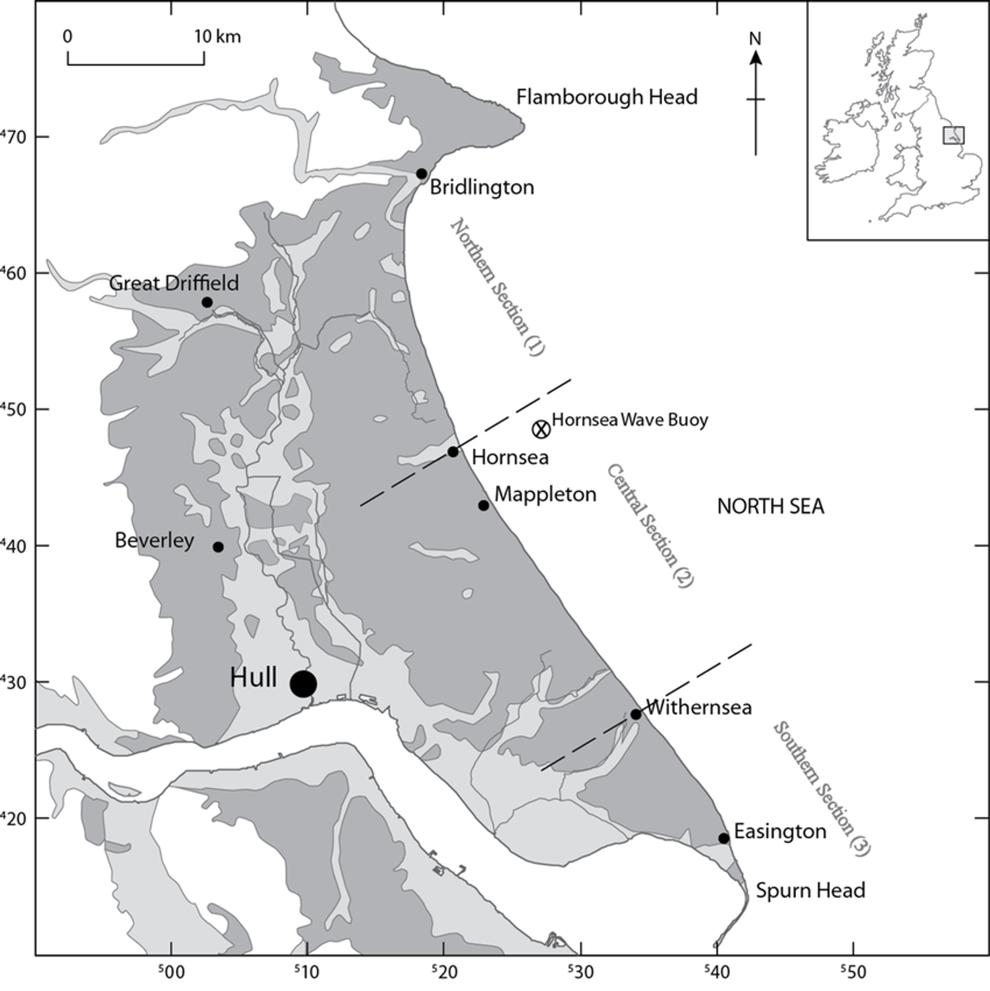
Holderness Coast*
| Context | ● 50km from Flamborough to Spurn Head ● 1 of the fastest eroding coastlines in Europe ○ 2m per year ● Long fetch (500-800km) |
|---|---|
| Physical factors | Weather ● Winter storm surges = strong waves & higher sea levels ○ Also intensify sub aerial processes ○ Saturated clay cliffs suffer increased runoff leading to slumping & other forms of mass movement Waves ● NE fetch • (500-800km) ● Destructive waves erode the beaches and attack the foot of the cliffs, removing the clay in suspension ○ LSD then carriers this material S ■ The tides and the lower energy environment of the Humber estuary allows sediments to collect forming a spit, mudflats and sand dunes near to spurn head Geology ● Mainly chalk & boulder clay (rapidly eroded by the sea) ○ Flamborough head • more resistant chalk has been able to survive the large-scale erosion ○ The boulder clay cliffs to the S are more easily eroded & their retreat has formed the sweeping bay of Holderness ○ The differential rate of erosion has given the coastline its distinct shape |
| Well known features & processes | ● The chalk headland and cliffs near Flamborough ● The retreating clay cliffs of the Holderness Bay ● The 6km spit at Spurn point ● Over time very vulnerable to mass movement, including rotational slip |
| Flamborough head | ● Illustrates how wave erosion can produce the arch, stack and wave-cut platform features associated with chalk rock ○ The chalk is resistant to erosion and has a distinctive lithology ○ The horizontal bedding planes are seen in cliffs at Flamborough Head and North Landing where they assist in the development of wave cut platforms |
| The Holderness cliffs | ● These Boulder clay cliffs are formed from material left by ice sheets • retreating at an average of 2m per year (10x the rate of chalk cliffs) ○ A result of the combined effects of land processes and sea erosion ■ On land • rainwater enters the clay and the weight of the water causes material to slide seawards • cause slumping ■ Cliff-foot • fine clay is easily removed by waves exposing the cliff foot to sea erosion (cliffs at Easington are retreating locally at rates of over 10m a year) |
| Spurn Head | ● Sediments are deposited here where the winds, waves and river estuary have created a recurved spit • grows by approx 10cm each year |
| Human impacts | ● Physical processes have been turned into hazards & a potential threat to life and
property because of increasing population levels in the area due to retirement &
tourism
● LSD has been impacted due to the implementation of unsuitable defence strategies
● Global warming • sea level rising, increasing frequency and intensity of storms
(Humber Estuary particularly at risk • ½ mil people live less than 2m above current
sea level)
|
| Impacts of
coastal erosion |
● Economic
○ Golden sands resort lost 100 chalets in 15 yrs
○ Lack of tourism
○ 80,000m² of farmland lost per yr
■ By 2100, 200 homes & many roads projected to be lost to sea
● Social
○ Businesses close • lack of tourism
○ No insurance for coastal erosion as too expensive/not available
○ Houses
■ DEFRA, E Riding Development fund raised 1.2 mil which supported 36
homes financially
● Environmental
○ Wildlife behind Spurn Point less diverse
■ Due to lack of sediment to support |
| Hard engineering
strategies |
● Sea walls • Hornsea & Withernsea
● Revetments • Easington gas terminal (handles 25% of North sea production of
natural gas)
● Gabions • Skipsea
● Groynes • Hornsea (repairing and new ones = £5.2 mil), Withernsea and Mappleton
● Rip-rap • Withernsea and Easington
● Cliff regrading • Mappleton |
| Soft engineering | ● Beach nourishment • Hornsea and Mappleton
● Do nothing • Neck of spurn head
● Managed retreat • Suggested for Hornsea in 1994 but not implemented |
| Mappleton | ● In 1786 • Village was 3.5km from sea but by 1988, the sea was on the doorstep
● Due to pressure from local residents, in 1991 a scheme was implemented costing £2.1
mil (supported by EU funding)
○ The scheme included:
• 2 rock groynes
• A rock revetment
• Regrading of cliffs
• Beach nourishment
• New access road, car park & toilets for visitors |

500K+ Students Use These Powerful Tools to Master Case Study → Policy decisions - Holderness Coast For their A-Level Exams.
Enhance your understanding with flashcards, quizzes, and exams—designed to help you grasp key concepts, reinforce learning, and master any topic with confidence!
664 flashcards
Flashcards on Case Study → Policy decisions - Holderness Coast
Revise key concepts with interactive flashcards.
Try Geography Flashcards17 quizzes
Quizzes on Case Study → Policy decisions - Holderness Coast
Test your knowledge with fun and engaging quizzes.
Try Geography Quizzes29 questions
Exam questions on Case Study → Policy decisions - Holderness Coast
Boost your confidence with real exam questions.
Try Geography Questions27 exams created
Exam Builder on Case Study → Policy decisions - Holderness Coast
Create custom exams across topics for better practice!
Try Geography exam builder22 papers
Past Papers on Case Study → Policy decisions - Holderness Coast
Practice past papers to reinforce exam experience.
Try Geography Past PapersOther Revision Notes related to Case Study → Policy decisions - Holderness Coast you should explore
Discover More Revision Notes Related to Case Study → Policy decisions - Holderness Coast to Deepen Your Understanding and Improve Your Mastery
96%
114 rated
Topic 2: Coastal Landscapes & Change
The coast, and wider littoral zone
260+ studying
193KViews96%
114 rated
Topic 2: Coastal Landscapes & Change
Geological structure and the development of coastal landscapes
429+ studying
200KViews96%
114 rated
Topic 2: Coastal Landscapes & Change
Case Study → Geological structure - Isle of Purbeck
412+ studying
200KViews96%
114 rated
Topic 2: Coastal Landscapes & Change
Rates of coastal recession and stability
357+ studying
196KViews