Photo AI
Last Updated Sep 26, 2025
The UK's Physical Landscape Simplified Revision Notes for GCSE AQA Geography
Revision notes with simplified explanations to understand The UK's Physical Landscape quickly and effectively.
379+ students studying
3.1.1 The UK's Physical Landscape
The physical landscape of the UK is diverse, with a variety of landforms shaped by geological processes over millions of years.
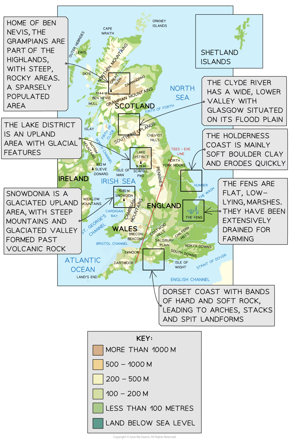
1. Mountain Ranges
- Location: The UK has several mountain ranges, with the most significant located in the north and west.
- Examples:
- The Scottish Highlands: Home to Ben Nevis, the highest peak in the UK (1,345 meters).
- The Lake District: Known for its rugged terrain and glacially-carved valleys.
- Snowdonia in Wales: Contains Mount Snowdon, the highest mountain in Wales (1,085 meters).
- Formation: These mountains were primarily formed during the Caledonian and Variscan orogenies (mountain-building periods) hundreds of millions of years ago.
2. Upland Areas
- Location: Upland areas are found mainly in the north and west of the UK.
- Examples:
- The Pennines: Often referred to as the "backbone of England," running down the center of Northern England.
- Dartmoor and Exmoor: Upland areas in the southwest with moorland and tors (rocky outcrops).
- Characteristics: These areas are characterized by their higher elevation, rugged terrain, and often harsher climates. They are shaped by erosion and weathering processes, with features such as valleys, ridges, and escarpments.
3. Lowland Areas
- Location: Lowland areas are predominantly in the south and east of the UK.
- Examples:
- The South Downs and North Downs: Rolling hills in southeast England.
- The Fens: A flat, low-lying area in East Anglia, much of which has been drained for agriculture.
- Characteristics: These areas are generally flatter, with softer, more fertile soils compared to upland areas. They are often used for agriculture due to the more favorable conditions.
4. Coastal Landscapes
- Location: The UK has an extensive coastline, with a variety of coastal landscapes.
- Examples:
- The Jurassic Coast: A World Heritage Site in Dorset and East Devon, known for its cliffs, arches, stacks, and fossils.
- The Norfolk Coast: Characterized by sand dunes, salt marshes, and shingle beaches.
- The White Cliffs of Dover: Famous chalk cliffs on the southeastern coast.
- Formation: Coastal landscapes are shaped by processes such as erosion, transportation, and deposition. Features like headlands, bays, cliffs, and beaches are common.
5. River Landscapes
- Examples:
- The River Thames: Flows through southern England, including London, and has shaped the surrounding landscape.
- The River Severn: The longest river in the UK, with a dramatic estuary and features such as oxbow lakes and floodplains.
- The River Tees: Known for its waterfalls, such as High Force, and steep-sided valleys in its upper course.
- Formation: Rivers shape the landscape through erosion, transportation, and deposition, creating features like valleys, floodplains, and deltas. The upper, middle, and lower courses of rivers each have distinct characteristics.
6. Glaciated Landscapes
- Location: Found in upland areas that were covered by ice during the last Ice Age, particularly in Scotland, the Lake District, and North Wales.
- Examples:
- Glacial Troughs: U-shaped valleys formed by the erosion of glaciers, such as Glen Coe in Scotland.
- Ribbon Lakes: Long, narrow lakes in glacial valleys, like those in the Lake District (e.g., Windermere).
- Moraines: Deposits of rock and debris left behind by retreating glaciers.
- Formation: Glaciers carve out valleys and deposit materials, leaving behind distinctive features that define the landscape today.
The UK's physical landscape is a product of its geological history and the various processes that have shaped it over millions of years. From rugged mountains and rolling hills to flat plains and dramatic coastlines, the UK's landscapes are diverse and offer a range of geographical features to study. Understanding these landscapes involves recognising the processes of erosion, weathering, deposition, and glaciation that have shaped the terrain over time.

500K+ Students Use These Powerful Tools to Master The UK's Physical Landscape For their GCSE Exams.
Enhance your understanding with flashcards, quizzes, and exams—designed to help you grasp key concepts, reinforce learning, and master any topic with confidence!
40 flashcards
Flashcards on The UK's Physical Landscape
Revise key concepts with interactive flashcards.
Try Geography Flashcards5 quizzes
Quizzes on The UK's Physical Landscape
Test your knowledge with fun and engaging quizzes.
Try Geography Quizzes1 questions
Exam questions on The UK's Physical Landscape
Boost your confidence with real exam questions.
Try Geography Questions17 exams created
Exam Builder on The UK's Physical Landscape
Create custom exams across topics for better practice!
Try Geography exam builder12 papers
Past Papers on The UK's Physical Landscape
Practice past papers to reinforce exam experience.
Try Geography Past PapersOther Revision Notes related to The UK's Physical Landscape you should explore
Discover More Revision Notes Related to The UK's Physical Landscape to Deepen Your Understanding and Improve Your Mastery
Load more notes