Photo AI
Last Updated Sep 27, 2025
Comparing OS Maps and Aerial Photographs Simplified Revision Notes for Leaving Cert Geography
Revision notes with simplified explanations to understand Comparing OS Maps and Aerial Photographs quickly and effectively.
479+ students studying
Comparing OS Maps and Aerial Photographs
Comparing OS Maps and Aerial Photographs
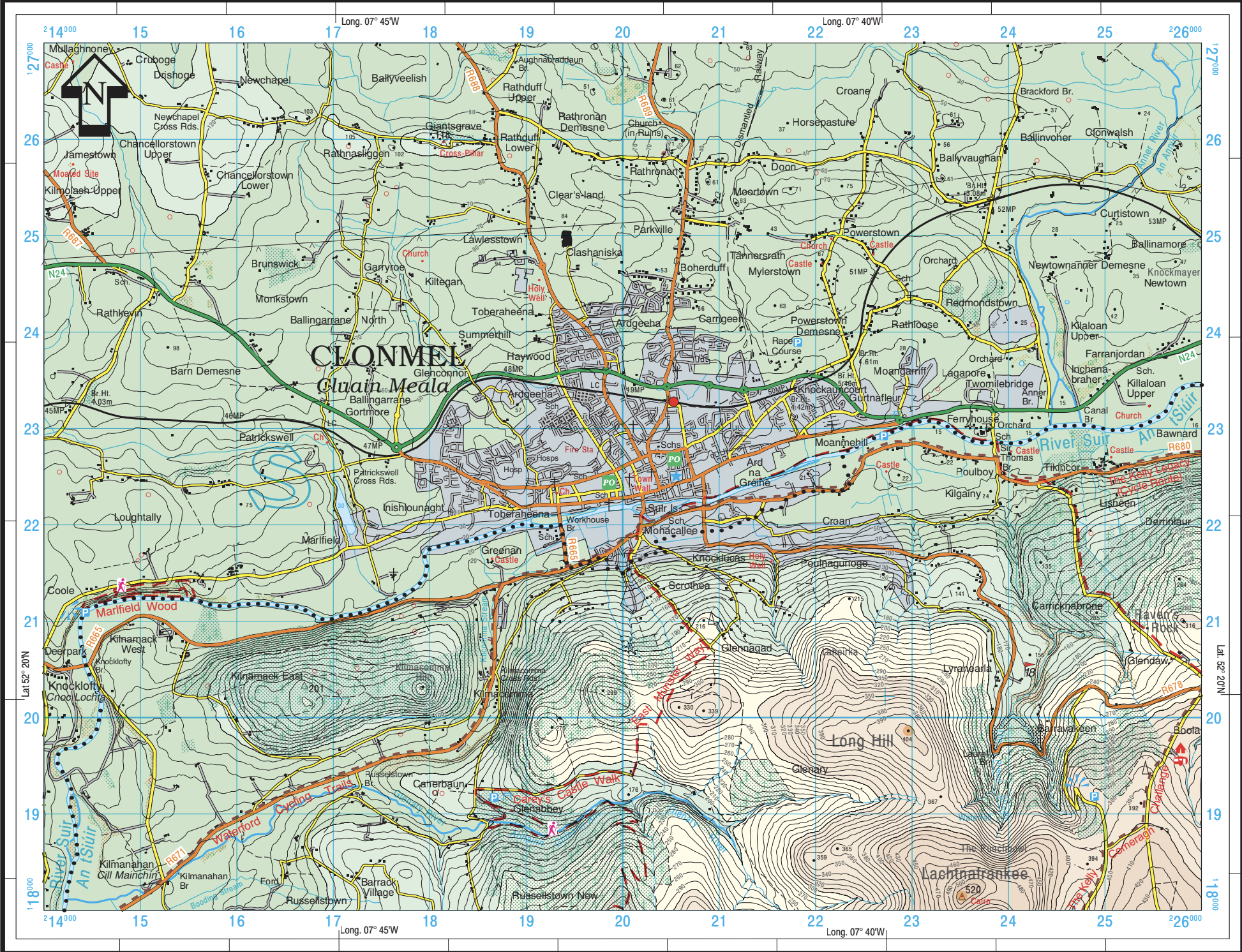
OS Maps
Aerial Photographs
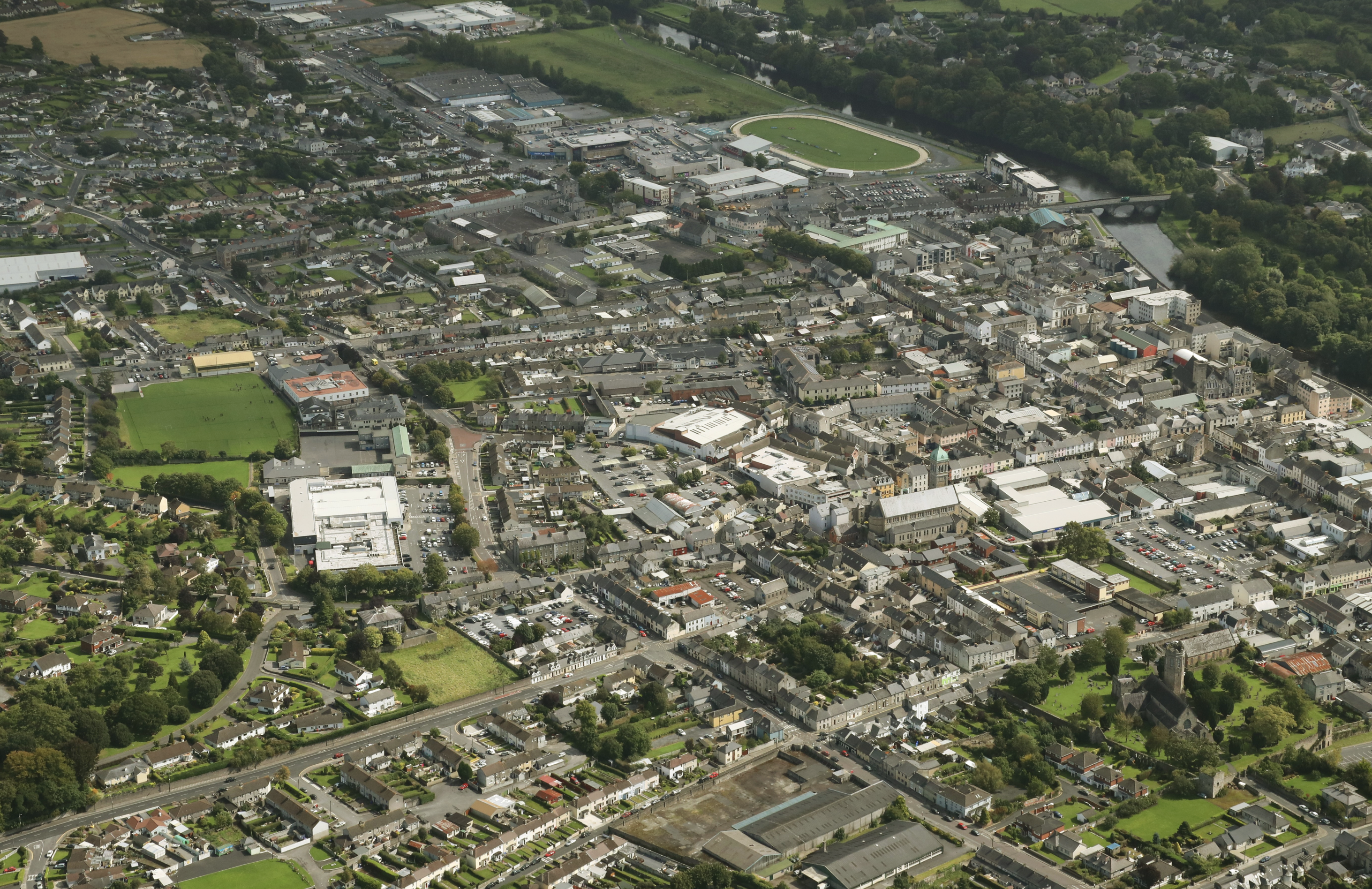
Key Similarities
Represent the Same Area
- Both OS maps and aerial photographs often depict the same geographical area, enabling cross-referencing of features.
Show Physical and Human Features
- Physical Features:
- Landforms such as rivers, mountains, and forests are visible in both.
- Human Features:
- Settlements, transport networks, and land use are depicted in detail.
Tools for Analysis
- Both can be used to study:
- Relief (elevation and slopes).
- Land use patterns.
- Transport and settlement development.
Key Differences
| Feature | OS Maps | Aerial Photographs |
|---|---|---|
| Perspective | Planimetric (top-down view) | Bird's-eye view (angled or vertical) |
| Symbols | Uses a legend to represent features | Shows actual visuals of features |
| Relief | Contour lines, spot heights, and shading | Shadows and textures to infer elevation |
| Detail | Simplified, focusing on key features | Highly detailed, showing all visible features |
| Scale | Fixed (e.g., 1:50,000) | Can vary and must often be estimated |
How to Compare OS Maps and Aerial Photographs
Identifying Features
- Match features like roads, rivers, and buildings between the map and photograph.
Analysing Relief
- OS Maps: Use contour lines to determine elevation and slope.
- Aerial Photographs: Look at shadows and textures to interpret height and shape.
Studying Patterns
- Compare settlement layouts, such as nucleated, linear, or dispersed patterns.
- Observe transport networks and their connections.
Understanding Land Use
- OS maps use symbols to represent land use (e.g., forests, agriculture).
- Aerial photographs visually display the landscape, allowing for detailed land-use interpretation.
Applications of Comparing OS Maps and Aerial Photographs
Fieldwork and Investigation
- Cross-reference maps with photographs to confirm locations and analyse spatial relationships.
Urban and Rural Studies
- Analyse settlement growth, land-use changes, and transport networks by combining the two sources
Tips for Effective Comparison
- Use the map's legend and the photograph's visual details to identify corresponding features.
- Pay attention to scale and orientation to align both correctly.
- Practice comparing OS maps and photographs from past papers to build confidence.

500K+ Students Use These Powerful Tools to Master Comparing OS Maps and Aerial Photographs For their Leaving Cert Exams.
Enhance your understanding with flashcards, quizzes, and exams—designed to help you grasp key concepts, reinforce learning, and master any topic with confidence!
147 flashcards
Flashcards on Comparing OS Maps and Aerial Photographs
Revise key concepts with interactive flashcards.
Try Geography Flashcards16 quizzes
Quizzes on Comparing OS Maps and Aerial Photographs
Test your knowledge with fun and engaging quizzes.
Try Geography Quizzes29 questions
Exam questions on Comparing OS Maps and Aerial Photographs
Boost your confidence with real exam questions.
Try Geography Questions27 exams created
Exam Builder on Comparing OS Maps and Aerial Photographs
Create custom exams across topics for better practice!
Try Geography exam builder47 papers
Past Papers on Comparing OS Maps and Aerial Photographs
Practice past papers to reinforce exam experience.
Try Geography Past PapersOther Revision Notes related to Comparing OS Maps and Aerial Photographs you should explore
Discover More Revision Notes Related to Comparing OS Maps and Aerial Photographs to Deepen Your Understanding and Improve Your Mastery