Photo AI
Last Updated Sep 27, 2025
Where Earthquakes Occur Simplified Revision Notes for Leaving Cert Geography
Revision notes with simplified explanations to understand Where Earthquakes Occur quickly and effectively.
278+ students studying
Where Earthquakes Occur
Location of Earthquakes
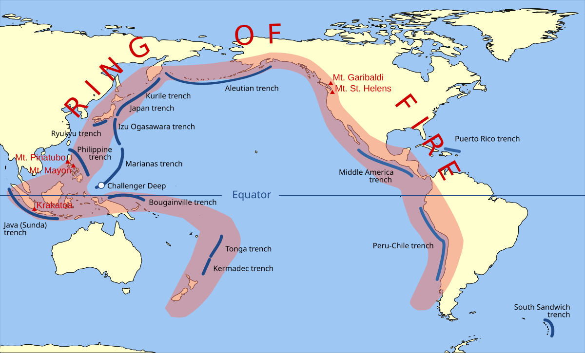
- Earthquake's occur at convergent, divergent and transform plate boundaries.
- The most dangerous earthquakes are associated with subduction zones.
- The subduction zone off the coast of Japan is the most deadly in the world as the Pacific plate is brought under the Eurasian plate.
- This area is part of the Pacific Ring of Fire – where the world's most active volcanoes and earthquakes are.
- Earthquakes can also occur at transform plate boundaries such as the San Andreas fault.
- They also occur at divergent plate boundaries such as the Mid Atlantic Ridge but they are not frequent or dangerous.
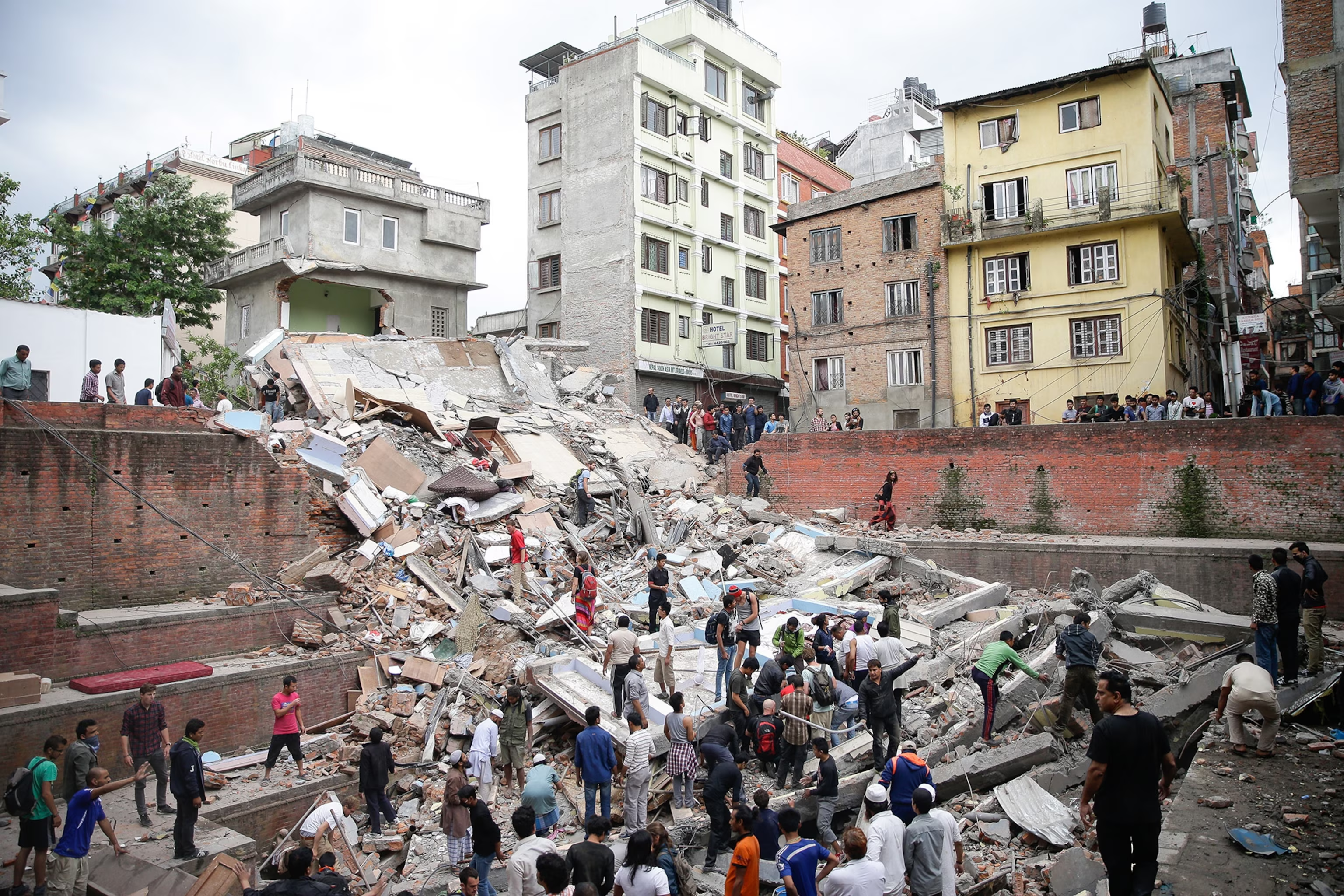
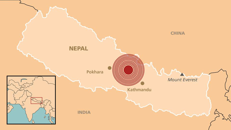
Case Study: Nepal Earthquake, 25th April 2015
Where/Why?
- 7.8 magnitude earthquake hit 77km north of Nepal's capital city, Kathmandu
- This region lies along an active fault line over 1,000km long and this earthquake was a dangerous shallow earthquake as the focus was only approx. 15km below the surface of the Earth
- It directly/indirectly affected 8 million people
- Indian plate and overriding Eurasian plate collided – they are converging at a rate of 5cm per year and this collision is why the Himalayan mountain range is getting higher (Mt. Everest is still growing)
- Original earthquake was followed by strong aftershocks and another earthquake triggered by the stress of this seismic activity
- The last major earthquake to hit the region was in 1934 when 17,000 people were killed. The pattern of earthquakes in this region have been recorded since the 13th century with seismic gaps of 75-80 years
- The biggest aftershock came on the 12th of May – 17 days after the original earthquake hit and it registered 7.3 on the Richter Scale. The epicentre was 76km away from the Mt. Everest base camp. It affected Northern India, Tibet and Bangladesh, killing 48 people and injuring up to 1,000 people. 6 more aftershocks were also felt in the region with none of these recording a strength of more than 5 on the Richter Scale.
Effects
- 8,000 killed, 10,000 injured
- Rescue teams used sniffer dogs and heat-seeking equipment to search for survivors for the days after but this was not possible in remote areas, so local people had to search through the rubble
- Many villages were destroyed or buried by avalanches and landslides (earthquakes and aftershocks caused 3,000 of these) such as those in Langtang Valley 435 people lived here but now only one house still exists as the rest slid 700 metres downhill
- 130,000 buildings destroyed, including 60m high Dharahara Tower built in 1832 for queen of Nepal
- 24,000 were homeless having fled the region
- Immediate cremation of deceased was ordered to prevent the spread of disease
- Tourism was majorly affected and is a big long-term effect, causing economic downturn
- Over 100,000 visitors trekked Mount Everest and the surrounding region in 2013, providing a major source of income for locals
- Due to safety fears these numbers have massively declined
- Difficult terrain meant that delivering aid (food, shelter, clean water) was slow
- Nepal govt. estimated that they needed €1.7 billion in aid to rebuild and repair infrastructure such as roads and hospitals
- Govt. has been criticised for being corrupt in the past so this aid is slow in coming with UN giving €3 million in aid and Ireland delivering 63 tonnes of life-saving supplies
- But future growth and redevelopment will be very difficult and slow
Tsunamis
- A tsunami is a large wave created by an earthquake under the ocean
- Can have devastating effects in minutes so an early warning system is essential
Warning Systems and Damage Prevention
- 28 countries in the Pacific have tsunami warning systems including Japan
- Tsunami sensors collect data on the ocean floor as do tide gauges
- This information is then transmitted via a satellite to tsunami warning centres to be interpreted
- Regular updates are then provided on local television and radio stations
- Local authorities are responsible for evacuation plans
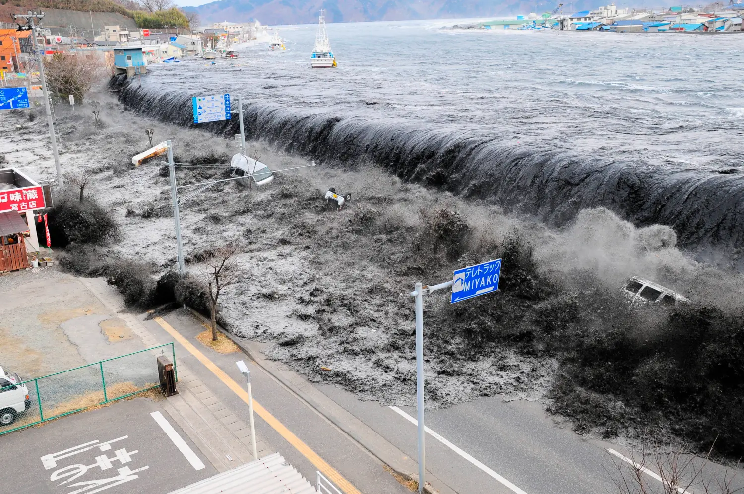
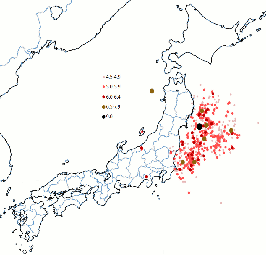
Case Study: Japanese Earthquake, 11 March 2011
Where/Why?
- 8.9 magnitude Earthquake lasting 2 and a half minutes, 130km off the coast of Japan also causing a Tsunami
- Japan is located on a convergent plate boundary at a subduction zone, marked by the deep-sea Japan trench – part of the Pacific Ring of Fire
- Here, the Pacific Plate is sinking underneath the Eurasian Plate
- Tension built up between the two plates and eventually the edge of the Eurasian Plate jumped backwards 5-8 metres over a 180km stretch of land
- A shallow focus earthquake occurred as a result which displaced a large volume of water, creating a tsunami
- The waves remained quite small in the ocean but built up to approx. 10 metres high once they hit the shallow water
- The huge wave flew inland for several kilometres leaving a path of destruction in its wake
- Tsunami warnings were only received 10 minutes before the wave hit so locals did not have time to react
Effects
- Coast was transformed into a muddy swamp of material thrown up by the tsunami
- Towns and villages were completely destroyed including a town of 10,000 people
- 27,000 people were killed with 90% of them drowning as a result of the tsunami
- Fukushima nuclear power plant was damaged sparking fears of a radioactive leak – a state of emergency was declared as a result with a 20km radius cleared around the plant as radioactive material leaked out
- 500,000 left homeless but the earthquake itself did little structural damage due to Japans strict building regulation

500K+ Students Use These Powerful Tools to Master Where Earthquakes Occur For their Leaving Cert Exams.
Enhance your understanding with flashcards, quizzes, and exams—designed to help you grasp key concepts, reinforce learning, and master any topic with confidence!
190 flashcards
Flashcards on Where Earthquakes Occur
Revise key concepts with interactive flashcards.
Try Geography Flashcards19 quizzes
Quizzes on Where Earthquakes Occur
Test your knowledge with fun and engaging quizzes.
Try Geography Quizzes29 questions
Exam questions on Where Earthquakes Occur
Boost your confidence with real exam questions.
Try Geography Questions27 exams created
Exam Builder on Where Earthquakes Occur
Create custom exams across topics for better practice!
Try Geography exam builder47 papers
Past Papers on Where Earthquakes Occur
Practice past papers to reinforce exam experience.
Try Geography Past PapersOther Revision Notes related to Where Earthquakes Occur you should explore
Discover More Revision Notes Related to Where Earthquakes Occur to Deepen Your Understanding and Improve Your Mastery