Photo AI
Last Updated Sep 26, 2025
Regional Concepts Simplified Revision Notes for Leaving Cert Geography
Revision notes with simplified explanations to understand Regional Concepts quickly and effectively.
375+ students studying
Regional Concepts
Concept of a Region
- Climatic (physical) regions
- Geomorphological (physical) regions
- Administrative regions
- Cultural (language or religious) regions
- Socio-economic regions
- Nodal (city) regions

What is a Region?
A Region is an area that has certain characteristics that set it apart from other areas. These characteristics can be physical (climate or landscape), cultural (language or religion) or socio-economic characteristics such as levels of economic wealth.
- Regions can vary greatly in size. Some are very large (Indian Subcontinent) while others are small (The Burren)
- Regions can change over time, e.g. the urban area of Dublin has expanded greatly over the last 100 years
- Some regions have precise boundaries (European Union) whilst others may merge gradually into each other (climatic regions)
Geography
Regional Concepts
Climatic Region
There are many different climates around the world with each one influencing regions in different ways depending on temperature, precipitation and weather systems.
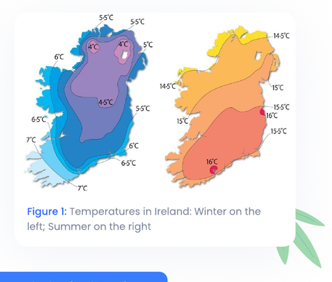
Case Study: Cool Temperate Oceanic Climate
Location: North-Western Europe, e.g. Ireland
-
Located between 40 and 60 degrees north and south of the equator
-
Ireland's climate is typical of the cool temperate oceanic type:
-
Winters are usually mild (around 6°) while summers are moderately warm (around 16-19°). As a result, there is a small temperature range
-
Precipitation is frequent throughout the year, especially in Winter with annual range rainfall ranging from 800mm to 2,500mm in mountainous areas
-
-
Ireland's climate is influenced by several factors:
Latitude
- Ireland's 'mid-latitude' location (between 51.5 and 55.5 degrees north of the equator) means that there are no hot or cold extremes

Regional Concepts
-
It is also in an area where cold polar and warm tropical air masses meet over the Atlantic which creates cyclones or depressions
-
These depressions bring frequent spells of windy, cloudy and wet weather
Influence of the sea
-
The sea heats slowly in summer and cools slowly in winter as it takes longer to heat up and cool down than land
-
This reduces summer temperatures but also keeps winters mild
-
This is due to the North Atlantic Drift, a warm ocean current that helps to increase air temperature. Therefore, Ireland remains mostly ice-free during winter, especially along our shores
Prevailing Winds
-
South-Westerly wind is the most common – blows over the Atlantic Ocean to Ireland
-
Brings the moderating effect of the sea on the temperatures of Ireland
-
They also absorb a large amount of water vapour and carry a large amount of moisture once these winds reach Ireland
-
As these winds ascend over mountains, much of this moisture is dropped in the form of relief rain
Regional Concepts
-
Ireland's prevailing winds can also bring cyclones (systems of winds rotating in an anti-clockwise direction) which result in stormy weather
-
These cyclones often dominate our weather conditions in winter
Geomorphological Regions
These regions differ from other regions due to their unique structure (physical make up) or relief (landscape). Munster Ridge and Valley is an example.
Case Studies:
- The Burren (karst region)
- Northern European Plain
Geography
Regional Concepts

The Burren
-
Notes from the formation of limestone, chemical weathering and karst landscapes can be used for this topic also
-
The Burren is a distinctive karst region where limestone is exposed at the surface without soil, vegetation or surface water
-
The Burren was once covered with soil. Some of this was removed during the Quaternary ice age by an ice sheet
-
Further soil was removed during the Bronze Age when farmers removed trees. Loose soil was then removed by water and wind, leaving the limestone surface exposed
-
Carbonation has influenced the region through the creation of features such as a limestone pavement with clints and grikes, passages and caves (give a quick explanation of these features in an essay)
-
The Burren contains unusual plant life with unique plant species thriving within the sheltered grikes on the Burren's surface such as the very rare green winged orchid
-
The Burren plays host to 70% of Ireland's 900 native plant species
Regional Concepts

Figure 2: Limestone Pavement, Clints and Grikes
Geomorphological Regions
Soils:
-
North European Plains is located on the Northern half of the European continent, stretching from the Paris Basin to central Europe including countries such as France, Belgium and the Netherlands
-
About 60 million years ago the region lay below sea level which allowed sedimentary rocks to develop
-
During the Alpine folding the majority of land was lifted above sea level, excluding the Netherlands who remains below sea level and rely on polders to reclaim land from the sea – it is a flat area as a result
-
During the quaternary period, a large ice sheet spread out over the area
Geography
Regional Concepts

-
When this melted it left behind fertile boulder clay
-
Strong winds blew these deposits southwards creating yellow/brown limon soils which are very fertile soils and make up most of the productive Paris Basin
-
Some of Europe's biggest rivers (Seine, Rhine) flow through the region increasing the fertility of the region through alluvial deposits
Climate:
-
Cool Temperate Oceanic
-
Moderate with rainfall throughout the year – slightly different temperature range to Ireland due to distance from seas/oceans
Relief:
-
Densely populated
-
Some of the most modern communication links (road and rail) in the world, aided by the lowland nature of the plain – cheaper and easier to build and plan
Economy:
-
Heavily Industrialised
-
Rooted in the industrial revolution, making great use of coal and iron deposits
-
Much of the region is involved in large scale mechanised farming
Regional Concepts
Geography
Administrative Regions
These regions are defined by governments who divide the country into smaller regions. They can be small scale such as local county councils or larger scale such as regional authorities.
Case Studies:
Local Irish Government
Local Level

- 29 County Councils in total
- Dublin has three as well as a city council. Cork, Galway and Waterford also have city councils
- Elected county council representatives control day to day running of their county dealing with areas such as waste disposal, water supply and planning permission
- Every 5 years a development plan is drawn up and funding is drawn from areas such as planning fees, commercial rates and funds from central government
Regional level
- National Development Plan (NDP) 2000 – 2006 divided Ireland into two regions – peripheral BMW (Borders, Midlands and West) and the core South-East region
Regional Concepts
-
The NDP deals with transport networks, public services and distribution of EU funds
-
The NDP 2010 – 2016 encouraged balanced regional development, moving away from a focus on Dublin – it identified Cork, Waterford, Galway, Limerick and Dublin as a focus for investment, but it had a vastly reduced budget of €39 billion
-
Spending on key areas was cut e.g. Education from 25.7% to 4.2% and Agriculture from 8.3% to 1.6%
The lowest tier of Irish government consists of 75 town councils and 5 borough councils which govern large urban areas such as Kilkenny and Drogheda.
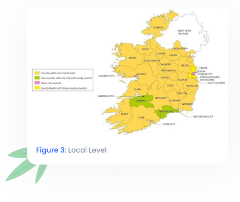
Figure 3: Local Level
Geography
Regional Concepts

Regional Level
-
In 1982 law was passed giving power to Regional authorities in France with each one being made up of groups of Départements with the aim to decentralise some power from French Government
-
Each authority looks after it's regions finances, schools and heritage
Département level
-
Regional government is divided into 96 Départements, similar to Ireland's counties
-
They were established after the French revolution 1789 with each one having a unique two-digit number – example: Number 75 is in Paris
-
They are responsible for planning, social services and motor tax
- The last two numbers on car number plates are the two-digit codes of the Département that the car was registered in
Commune Level
-
Smallest division, similar to villages/parishes
-
There are over 36,000 with each one having its own mayor
-
They are responsible for water supply, lighting and other minor issues
Geography
Regional Concepts
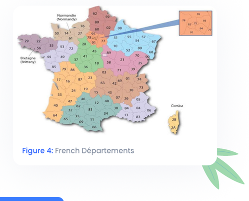
Figure 4: French Départements
Cultural Region
Cultural Regions are defined as areas where people share a common language, religion and traditions or way of life.
Within countries, people may speak another language to the official one, due to reasons such as migration or colonisation.
Religion can also shape people's identity, and this has been the cause of much social conflict, however tolerance of other religions is now widely accepted.
Geography
Regional Concepts

Language Region: The Gaeltacht
-
These are peripheral areas in Ireland where over 80% of the population speak Irish as their first language, example An Rinn, Co. Waterford, however they are mostly located on the West coast of Ireland
-
In 2011 100,716 people lived in Gaeltacht areas but this is decreasing
-
After the Great Famine in the 1840's there was huge emigration from these areas. This migration has continued due to factors such as remoteness and lack of funding
-
Outside influences such as radio and tv have encouraged the English language leading to the decline of the Irish language
-
Several measures were taken to prevent this decline:
- TG4 was established in 1996
- Ireland was made a bilingual state (two official languages)
- Údarás na Gaeltachta was set up in 1980 to look after social, cultural and economic development in these areas
- In 2005 Irish became the 21st official language of the EU
Geography
Regional Concepts
-
There are strict planning laws in these areas. Only native speakers or those with a reasonable fluency can apply for planning permission after a recent census showed that only 66,000 people use Irish as their first language
-
Sean Nós singing, ceilis and set dancing are used as activities to support the Irish language
-
The Governments national strategy plan for the Irish language 2010 – 2030 aims to increase the number of people using Irish on a daily basis beyond their years in school
Regional Concepts
There are strict planning laws in these areas. Only native speakers or those with a reasonable fluency can apply for planning permission after a recent census showed that only 66,000 people use Irish as their first language
Language Region : Belgium
Three official languages: French, Flemish and German
The capital Brussels is a bilingual city with both French and Flemish spoken – since the 1960's there has been tension between speakers of both languages
Flemish:
Northern Belgium, known as Flanders, has 60% of the population and has a very high birth rate
Speak Flemish and known as Flemings
Economy traditionally based on agriculture so was viewed as socially inferior
Discovery of oil and gas in the North Sea has helped the economic development of this area and many modern industries such as healthcare and electronics have now set up there
French:
Southern Belgium, known as Wallonia, close to France so speak French
Regional Concepts
-
Known as Walloons and were considered the cultural elite
-
Prosperity has fallen however due to the closure of coalfields (E.g. Sambre-Meuse coalfield in 1984) and high unemployment resulting in outward migration
German:
- Close to border with Germany people speak German
Result for the region:
-
Due to tensions, a new federal-style government was introduced
-
Each language region is responsible for its own educational, social and cultural affairs
-
Each region has its own flag, TV station and regional parliament
-
Government officials must answer questions in both main languages at press conferences
-
Each cultural group still lives apart from each other and tend to attend schools, vote for political parties and marry within their own groups
-
Belgium is a country divided by language
Geography
Regional Concepts

Figure 5: Language regions in Belgium
Socio-Economic Regions
Core Region:
-
Dominant region, most trade, industry, government influence, communications and affluent population
-
Experiences inward migration, e.g. Dublin
-
Core regions have well-developed, urban-based economies.
-
They have high per capita income (generally 10% higher than the EU average).
-
Living standards are high (a sign wealthy population).
-
There is high population density, particularly of young people (of working age). This is because of inward migration.
-
This is because of inward migration.
-
There is low unemployment.
Regional Concepts
Core regions have advanced technologies, communications and infrastructure.
- Productivity levels are high.
- Core regions dominate trade.
- There is investment in industry and services.
- Core regions are the seat of government and decision-making.
Peripheral Region:
- Less developed, lacking in industrial and infrastructural development and support
- Suffers from outward migration e.g. West of Ireland, Mezzogiorno
- Peripheral regions are underdeveloped.
- They have a harsh climate and landscape.
- They have low per capita income (generally 10% lower than the EU average).
- Living standards are low (a sign of a poor population).
- There is low inward migration of people of working age. The overall population density is low.
- There is high unemployment.
- Peripheral regions have poor technologies, communication and infrastructure.
Regional Concepts
Geography
- Productivity levels are low.
- Peripheral regions are overdependent on the primary sector.
- They are located far from an economic core and centre of influence (marginal location).
Regions of Industrial Decline
Socio-economic regions can change over time due to economic booms and recessions, natural resources being used up or global competition increasing
Examples include Greater Cork Area and Sambre-Meuse Valley
Greater Cork Area
- City grew during the 1970's, benefiting from membership to the EU in 1973
- Cork attracted many industries because of its port. It enjoyed high levels of employment until the 1980's through a variety of industries such as brewing and oil refining
- Due to a recession in the 1980's, deindustrialisation occurred as industries began to close down or scale back including Ford (car assembly) and Irish refinery (oil refinery)
- Unemployment rates rose rapidly as 5,500 jobs were lost in the region
Regional Concepts
Geography
-
Since the 1990's this situation has improved with investment in modern industries such as pharmaceutical (Pfizer) and IT (Apple) which in turn led to urban renewal and growth in the area
-
Government investment and planning helped to improve infrastructure, communications and port facilities making the area attractive for investors
-
As part of Ireland 2040, the area is set for major investment of at least €1 Billion which will lead to the creation of further jobs through projects such as the development of the Port of Cork in Ringaskiddy
Sombre-Meuse Valley
-
Located in Wallonia, Belgium stretching 150km from French border
-
Home to large coalfields and played a huge part in the industrial revolution of the 19th Century
-
It became a core region within Belgium and Europe as inward migration occurred from all areas of Belgium and Europe – 120 mines employed 120,000 people
-
After the 1950's these coalfields declined:
- Best coal was exhausted after 150 years of production
- Industries were attracted to Poland for cheaper coal
- Oil and Gas were replacing coal as cheaper, cleaner sources of energy
Regional Concepts
-
The last coalfield closed in 1984 and left the landscape covered in slag heaps (waste leftover from mining work). High unemployment in the region also meant that Flanders replaced Wallonia as the economic core of Belgium
-
Belgium and the EU invested in the area to try and revive it:
- Communication links – motorways to other cities – were improved
- New industrial estates were built, and the airport upgraded
- The landscape was cleaned up
- Workers were retrained in modern manufacturing skills
-
The area has shown some growth lately with further EU investment encouraging environmental schemes and worker retraining but the area is still less developed than the new economic core of Wallonia
Nodal Region
Urban areas are big towns or cities located at a nodal point or route focus. The area surrounding the city is called the hinterland or zone of influence.
Route Focus
- Also called a nodal point. Area where the main transport routes are concentrated. Towns often develop here.
Regional Concepts
Geography
Conurbation
- Large urban area formed when several towns and cities meet, e.g. in the Randstad in the Netherlands, 6 large cities have merged
Urban Sprawl
- Uncontrolled growth of city regions into the surrounding countryside
Characteristics of an Urban Region:
- High population density with constant inward migration
- Nodal Point – all routes converge
- Have many functions – commercial, administrative, educational, political, residential etc
- Cities and hinterlands are co-dependant – hinterland supplies produce (agricultural goods) and the city provides a market
- Large industrial centres with lots of employment
- Create environmental problems with the volume of people living in a small area

Examples: Dublin and Paris
- Will be covered in other notes on the regions themselves (GDA and Paris Basin)
simplestudy

500K+ Students Use These Powerful Tools to Master Regional Concepts For their Leaving Cert Exams.
Enhance your understanding with flashcards, quizzes, and exams—designed to help you grasp key concepts, reinforce learning, and master any topic with confidence!
240 flashcards
Flashcards on Regional Concepts
Revise key concepts with interactive flashcards.
Try Geography Flashcards5 quizzes
Quizzes on Regional Concepts
Test your knowledge with fun and engaging quizzes.
Try Geography Quizzes49 questions
Exam questions on Regional Concepts
Boost your confidence with real exam questions.
Try Geography Questions27 exams created
Exam Builder on Regional Concepts
Create custom exams across topics for better practice!
Try Geography exam builder47 papers
Past Papers on Regional Concepts
Practice past papers to reinforce exam experience.
Try Geography Past PapersOther Revision Notes related to Regional Concepts you should explore
Discover More Revision Notes Related to Regional Concepts to Deepen Your Understanding and Improve Your Mastery
Load more notes