Photo AI
Last Updated Sep 26, 2025
Soil Simplified Revision Notes for Leaving Cert Geography
Revision notes with simplified explanations to understand Soil quickly and effectively.
331+ students studying
Soil
General composition of soils
Soil is the thin layer of loose weathered material that covers the Earth's surface. It is made up of organic and inorganic material. Climate is one of the most important factors in the formation of soil.
Only 25% of the Earth's surface is covered in soil and only 10% of this can support the growth of food.
It takes approx. 400 years for 1cm of soil to form.
All soil types are made up of the following components, but in different amounts. This gives rise to many different soil types around the world.
Mineral Matter
- Mineral matter is the broken-down material of the parent rock (main rock in the area)
- It is the largest component of most soil types and can make up 45% of the soil
- Denudation broke the parent rock down into mineral matter
- This mineral matter could have originated in the area or transported by rivers, sea, wind or ice.

Soil
Mineral Particles
- Some minerals are soluble which is important as they help to nourish plants in the area
- The size of the particles is determined by the parent rock – sandstone has large particles while clay has small ones
- These particles can consist of stones, sand, silt and clay
Organic Matter
- Once living material of plants such as leaves and flowers and animal remains
- On average, it only makes up 5% of the soil, but is essential for soil fertility as it leads to the creation of humus
- Dead plant material, known as plant litter, is broken down by bacteria and micro-organisms as it decays
- It forms a thick, black, sticky substance called humus
- Humus is essential for plant growth as it is rich in nutrients
- It also gives soils a dark brown appearance and helps to bind soil together and hold moisture due to its sticky nature
- Living organisms can be anything from micro-organisms such as bacteria and fungi, to earthworms. They live in the soil and help with the breakdown of organic matter, aerating and mixing the soil
Soil
-
Some minerals are soluble which is important as they help to nourish plants in the area
-
The size of the particles is determined by the parent rock – sandstone has large particles while clay has small ones
-
These particles can consist of stones, sand, silt and clay
Organic Matter
-
Once living material of plants such as leaves and flowers and animal remains
-
On average, it only makes up 5% of the soil, but is essential for soil fertility as it leads to the creation of humus
-
Dead plant material, known as plant litter, is broken down by bacteria and micro-organisms as it decays
-
It forms a thick, black, sticky substance called humus
-
Humus is essential for plant growth as it is rich in nutrients
-
It also gives soils a dark brown appearance and helps to bind soil together and hold moisture due to its sticky nature
-
Living organisms can be anything from micro-organisms such as bacteria and fungi, to earthworms. They live in the soil and help with the breakdown of organic matter, aerating and mixing the soil
Geography
Soil
Water
- Essential for plant growth
- Found in pore spaces in the soil
- Water helps to dissolve minerals so that plants can take them in through their roots
- Generally, makes up 25% of soil but the climate influences this greatly
- In desert regions, soils would have very little water content, while soils in boggy areas can be saturated with water
Air
- Also found in pore spaces between soil particles
- Supplies nitrogen and oxygen which is essential for plant growth
- Also usually makes up 25% of soil but is more plentiful in large grained soils such as sandy soil
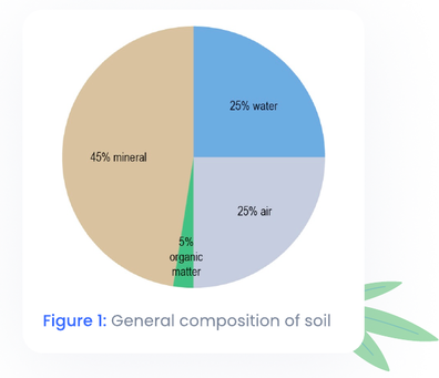
Figure 1: General composition of soil
Soil
Soil Profile
A soil profile is a vertical section cut through the soil, showing the layers that are present. There are normally three layers.
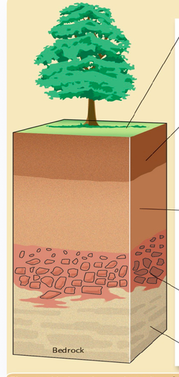
Figure 2
Geography
Soil

| Type of Soil | Description |
|---|---|
| Clay | Particle diameter less than 0.002mm – not visible to naked eye |
| Silt | Particle diameter between 0.002mm and 0.05mm – barely visible to naked eye |
| Sand | Particle diameter between 0.05mm and 2mm – visible to naked eye |
Clay Soils
- Contains 40-100% of clay particles – smallest sized particles
- Clay particles form a sticky soil when wet and will generally hold shape after drying
- Naturally high in nutrients so plants grow well
- In summer, the clay soil is often baked dry, with visible cracks on the surface – makes it difficult for water to get to the roots of plants. Opposite problem in Winter – waterlogging
- Better used for pastoral farming, as clay soil is difficult to plough
Geography
Soil

Silty Soils
- 40-100% silt
- Feels powdery to touch
- Soil peds stick together when wet but don't hold shape when dry
- Badly drained but do not become waterlogged very often
Sandy soils
- 85-100% sand
- Gritty feeling, tend not to stick together when wet
- Waterlogging is rare as they are free-draining due to large pore spaces, however watering and feeding of plants is needed on a regular basis as nutrients drain away easily
- Warm up quick in spring which aids early planting and cultivation
Geography
Soil
Loamy Soils
- Contains roughly equal amounts of clay, sand and silt
- Most plants grown in loam soils
- Brown and feels crumbly in texture
- Rarely waterlogged in winter or dry in summer so supports a wide range of plants
- Light and easy to dig and is naturally high in nutrients
- Suitable for farming and gardening
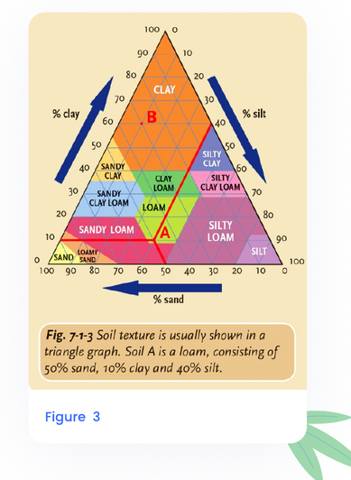
Figure 3
Soil
Structure
Structure indicates how the soil particles are held together. Clumps of soil bound together by humus and water are called peds. Peds control the amount of air and water contained in the soil. This is important for plant access to water. Overgrazing and overcropping damage the structure of the soil, reducing its ability to support plant growth.
There are three main structures – crumb, blocky and platy
Crumb soils
- Peds have a rounded shape
- Fertile soils as air and water can pass through easily – considered best soils for cultivation. Example loamy soils.
Blocky soils
- Close fitting, roughly cube-shaped particles
- Well-drained but can be compacted easily – addition of humus can help improve structure. Example: Sandy soils
Platy soils
- Peds form thin layers, overlapping each other – prevents good drainage
- Generally infertile. Example: Clay soils

Geography
Soil

Figure 4: Soil structure
Colour
Soil can vary in colour depending on the amount of organic matter in it. Colour mainly depends on parent material and the processes that have affected the soil.
-
Dark brown soils have a high humus content and are very fertile. Example: Brown earth soils
-
Grey soils are pale in colour as they have been leached of nutrients. Humus content is low. Example: Podzols
-
Red soils get their colour from iron oxide (rust) that is present in the soil. Found in tropical/equatorial regions. Example: Tropical red soils
Soil
Water Content

The amount of water that soils can hold depends on their structure, humus content and texture.
Humus helps to bind soil particles together while soils with a sandy texture are dry because water drains through them easily. Clay and soils with a platy structure can hold large quantities of water and become waterlogged as a result.
- Water is important for soil for a number of reasons
- Enables plants to absorb nutrients dissolved from the mineral grains
- Enables survival of micro-organisms responsible for humus formation
- Reduces soil erosion by wind by binding soil particles together
Geography
Soil
Organic Content
- Organic material of soil is made up of any living matter
- Plant litter is the dead plant material such as bark, twigs and leaves that have fallen to the ground
- Plant litter and any other decomposing material adds nutrients to the soil in the form of humus
- Soils with a high humus content tend to be dark brown in colour with a good crumb structure
- Humus also absorbs nutrients that could be washed out of the soil due to heavy rainfall (leaching)
Acidity
- Soil pH indicates how acidic or alkaline the soil is
- This has a huge effect on the type of organisms and plants that can live in the soil
- Most fertile soils have a pH of 6.5. Soils that are more acidic than this (e.g. peaty soils) can sustain very few organisms and plants so lime is sometimes added to soil to reduce the acidity level
Soil

Alkaline soils:
- have a high pH level (above 7)
- contain high levels of calcium and are limey
- develop on chalk or limestone regions
- also common in desert or drought regions.
Neutral soils: Neutral soils have a pH level of 7.
Acidic soils:
- have a low pH level (below 7)
- have been heavily leached by rainfall and lack minerals
- contain fewer living organisms the more acidic they are
- are usually infertile and crushed limestone can be added to reduce acidity level.
Figure 5: Coumshinganun
Processes affecting soil characteristics
No two soils are the same. Each soil undergoes different biological, physical and chemical processes which result in them developing different characteristics. The soil processes discussed below affect soil characteristics such as colour, texture, mineral content, humus content, water content and acidity.
Geography
Soil
Weathering

-
This is the physical and chemical breakdown of rocks and is responsible for the mineral part of soil
-
Soil grains can be released through physical weathering (e.g. freeze-thaw action) or chemical weathering
-
Soil grains produced by weathering keep the characteristics of the parent rock – pH, colour, texture
-
E.g. if the mineral comes from weathered sandstone, then the mineral will be acidic, pale brown and sandy in texture
-
Weathered shale will be black, platy structure and clay texture
-
-
Chemical weathering such as carbonation and oxidation can release nutrients such as phosphorous, calcium and iron from the mineral grains
-
Effect of carbonation on limestone leads to dark, alkaline soils rich in calcium
-
Hydrolysis releases clay particles from granite
-
Oxidation releases iron
-
Geography
Soil

Humification
-
Method by which dead organic matter is converted into humus – important for soil as it makes it fertile by releasing nutrients
-
Rain washes humus into the soil where it is then used by plant roots
-
Climate is an important factor affecting the rate of humification
- Humification is fast in hot, humid climates
- In deserts, the lack of water limits the amount of humus washed into the soil. These dry conditions do not suit the growth of fungi or activity of bacteria which limits the production of humus
- Humification occurs more slowly in Winter in temperate regions such as Ireland
- In cold arctic climates, humification may stop completely as dead plant and animal material will not decompose at all or else extremely slowly (e.g. ice age woolly mammoths preserved in Siberian permafrost)
Geography
Soil

Leaching
- Removal of nutrients from soil by water
- Rainwater washes soluble substances down through pores in the soil
- In wet areas, nutrients are washed from the soil altogether while in drier areas, they build up in a layer deep down in the soil
- A certain amount of leaching is needed to wash humus into the soil however excessive leaching is bad as it makes the soil infertile
- A and B horizons usually lack minerals due to leaching and may be pale in colour
Podzolisation
- Type of leaching that occurs when the rain is more acidic
- Podzol soils form under coniferous forest. When these forests die and decompose, they add to the acidity due to water absorbing humic acids from the rotting vegetation
- Acidic rainwater dissolves all minerals expect quartz as it is a resistant mineral.
Soil
-
Top layer of podzol soil is ash grey in colour due to the presence of quartz minerals. The layer below is darker in colour as it is enriched with the dissolved minerals from above
-
Podzols can also contain a layer of reddish iron oxide (rust) in the B horizon. This is formed when the iron-rich minerals collect together and is called a hard pan which prevents water from draining through the soil
Gleying
-
Process by which soil is waterlogged and lacks oxygen
-
In gley soils, the pores between soil peds are filled with water for most or all of the year. This prevents oxygen from getting into soil which means living organisms cannot survive
-
Climate and relief can lead to gleying processes occurring
- Heavy rainfall leads to waterlogging
- If the land has dips and hollows, then the water can gather in these which prevents drainage
-
Soils have patches of blue/grey due to the lack of oxygen
-
Common in Ireland's drumlin belt and where bedrock is impermeable
Geography
Soil

Laterisation
-
Type of severe chemical weathering that occurs in tropical and equatorial regions where leaching, carbonation and high temperatures combine to dissolve all minerals out of the soil except iron and aluminium oxides
-
Where heavy rainfall occurs, all alkaline material is removed from the soil, through carbonation – the pH od the soil is slightly acidic
-
The oxidation of iron and aluminium gives the soil a red appearance and they are known as latosols. When these soils dry out, it turns into a hard laterite
Salinisation
-
Occurs when mineral salts move up through the soil towards the surface rather than moving down
-
Can happen in hot desert areas where precipitation is low
- In these climatic conditions the amount of water evaporating out of the soil is higher than the amount going into it
-
This evaporation causes salts in the ground water to rise through the soil and collect in the upper layer. If the salt concentration becomes too high, then plants are poisoned and die
-
Irrigation salinisation is caused by excess water from irrigation which raises the water table, bringing salt to the surface. This can be reduced by using less water on crops or by growing crops which need less irrigation.
Soil

Calcification
-
Process by which calcium carbonate is concentrated near the surface of the soil – similar to salinisation
-
Occurs in regions of low rainfall – interior of continents
-
Amount of water drawn up by plants (transpiration) is greater than the amount of precipitation hitting the soil
-
As a result, calcium carbonate builds up in the upper layer – A horizon
-
Calcium carbonate is a useful substance for plants and soils often have good grass growth. When the grass dies, calcium carbonate is returned to soil
-
Calcified soils are alkaline in pH
Geography
Soil
Factors that influence soil formation
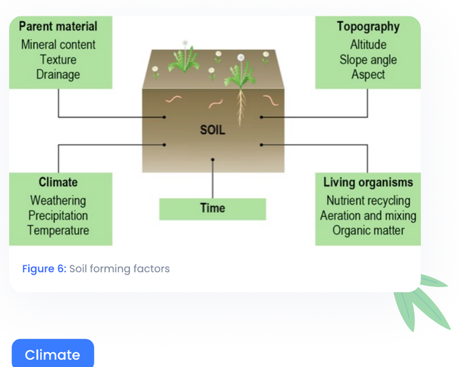
Figure 6: Soil forming factors
Climate
Climate has a major influence on the type of soil that develops as precipitation and temperature are the main agents that control the rate of weathering and biological activity in a region.
Geography
Soil
Hot climates
-
E.g. equatorial regions – weathering (mainly chemical) of soils is rapid, as is the decomposition of organic matter
-
Deep, fertile soils are abundant
Wet climates
- E.g. monsoon climates – soils prone to leaching and waterlogging
Cold climates
- E.g. tundra – thin, infertile soils develop as weathering and biological activity is limited
Dry climates
- E.g. Sahel – drought causes salinisation and calcification
Zonal soils are created in areas where particular climatic conditions have allowed them to develop e.g. zonal soil in Ireland is brown earth, developed due to cool temperate oceanic climate

Parent Material
-
This is usually the original bedrock of the area and it can affect soil characteristics such as pH, texture and ability to hold water
-
Igneous and metamorphic rocks tend to develop acidic soils
-
Sedimentary rocks can develop a variety of soils depending on rock type
Geography
Soil
-
This is usually the original bedrock of the area and it can affect soil characteristics such as pH, texture and ability to hold water
-
Sandstone produces an acidic, pale brown, well-drained, sandy soil (pH, colour, water content, texture)
-
Limestone produces calcium rich, dark-coloured soils e.g. terra rossa soils (pH, colour, texture)
-
Shale tends to produce dark grey, wet, clay soils (pH, colour, water content, texture)
-
-
In Ireland, most soils have developed on glacial deposits of boulder clay, sand and gravel, meaning the soils are deep, fertile and well-drained

-
In general, sloping land is well-drained and soils are quite dry, however mass movement such as soil creep can occur, so soil is generally quite thin
-
Flat upland areas are usually cold and wet, which can cause waterlogging and gley soils
- Biological activity of animals, plants and micro-organisms is slowed down due to low temperatures – dead organic matter builds up but is not converted into humus. As a result, upland areas are often infertile
Geography
Soil

-
Lowland areas are usually warmer and flatter, encouraging the build-up of soil
- Biological activity is greater as earthworms and micro-organisms converting dead organic matter into humus. Soil is more fertile here as a result
-
Local variations in aspect and relief may cause some lowland areas to be colder or wetter than usual which can lead to the formation of waterlogged and boggy soils
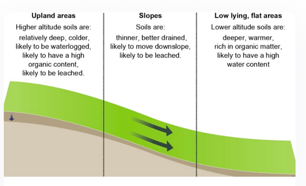
Figure 7: Effects of relief on soil
Geography
Soil
Living things/Biological activity
-
Living organisms have a huge impact on the decomposition of organic material and plant litter which is important for the formation of fertile soil
-
Living things within the soil can increase the fertility and aeration (amount of oxygen) of a soil
-
Earthworms, beetles and insect larvae burrow through the soil, creating air spaces for plant roots to use
-
When these creatures die, they decompose and add nutrients to the soil
-
-
Water collects inside these spaces and helps keep the soil moist
-
Micro-organisms such as fungi and bacteria add nutrients by decomposing dead material
-
The roots and foliage of plants help to bind soil together, preventing soil erosion. The leaves and branches of trees add a protective cover and prevent erosion through precipitation in wet climates

Geography
Soil
Time
-
Soil takes a long time to form – around 400 years for 1cm
-
Most soil in upland areas of Ireland are 10,000 years old – original soils removed during glaciations
-
Soil in lowland areas are much older
-
Soils develop quicker in areas of softer parent material, such as sandstone, than in harder areas, such as granite

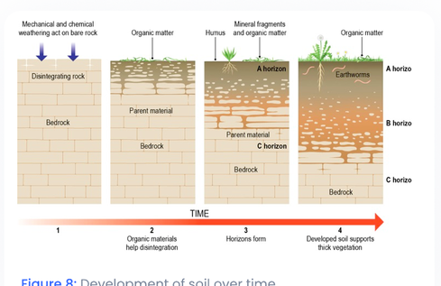
Figure 8: Development of soil over time
Soil
Soil Types
For the exam, you need to know one Irish soil type and one soil type from a continental or sub-continental region.
- Irish soil type = brown earth
- Continental/subcontinental = latosols (tropical rainforest) OR Aridosols (hot desert)
For the exam, you need to know one Irish soil type and one soil type from a continental or sub-continental region.
- Irish soil type = brown earth
- Continental/subcontinental = latosols (tropical rainforest) OR Aridosols (hot desert)
For Human Interaction with soils, we look at the Hot Desert climate and the Sahel region, so Aridisols is the better choice as there will be more of an overlap of information
For each soil type you need to know:
- General info
- Factors influencing formation – specific info building on the general info from the notes above
- Characteristics of soil type – specific info building on the general info from the notes above

Geography
Soil

Figure 9

Figure 10
Soil
Human Activity
Note: A question on human activity with soil usually focuses on two things – soil erosion and soil conservation.
Soil Erosion
Soil is a fragile resource and cannot be renewed once it is eroded. The conservation of soil fertility and prevention of soil erosion is an important issue for millions of people around the world, if food supplies are to be maintained.
Soil erosion is a serious problem worldwide. Every year, the US loses about 2 billion tonnes of topsoil while the loss of soil in China is a serious threat to the future food supply of the country.
This erosion can happen due to natural processes such as wind or flowing water or human activities. The three human activities we will look at are:
- Overgrazing
- Overcropping
- Deforestation

Geography
Soil
Case Study: Desertification and the Sahel
Soil erosion is leading to desertification in the Sahel region of Africa. Desertification is the spread of desert like conditions into new areas. It occurs close to desert areas.
In the Sahel region, soil erosion and desertification are happening as a result of three main activities – overgrazing, overcropping and deforestation.
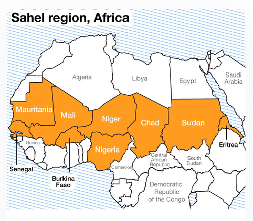
Figure 11: Development of soil over time
Geography
Soil

Desertification
Desertification is the spread of deserts. Its impact has increased in recent years due to climate change and human activity. The Sahel is a semi-arid region of Africa, running for 4,000km across Africa just south of the Sahara Desert. It was originally a grassland savannah biome and is being converted into a hot desert biome due to desertification. It has seasons of extreme heat and seasons of monsoon rain.
- Climate change has caused the world rainfall levels to decrease by one-third in the last 20 years
- Rising temperatures have led to higher rates of evaporation
- As a result, severe droughts have occurred in the Sahel in 1968 and 1973
- Competition for grazing lands and the need for more land to harvest the same amount of crops led to vegetation being removed from marginal land, with the land then being used for cultivation. These lands are the most vulnerable to desertification and once sand has invaded farmland, then it cannot be brought back under cultivation again
- Parts of the Sahel are overpopulated which places extra pressure on limited resources of fuel and food. There is a 2% increase in population per year due to high birth rates and falling death rates
- The Sahel supports a nomadic pastoral-based society as farmers need to move to new land as desertification spreads
Soil

- From the 1960's onwards, rain in the Sahel has decreased, bringing drought conditions
- Seasonal rains are less reliable and have reduced by 30% in the last 20 years
- Soils cannot support vegetation and the area is becoming increasingly barren as a result.
- The prevailing winds have blown away the regions topsoil
- Sahara Desert is spreading at a rate of 5-10km per year into vulnerable, marginal land, forcing farmers to constantly move and become nomadic
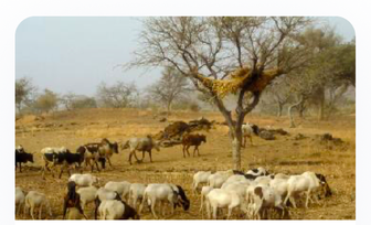
Overgrazing
Occurs when farmers allow too many animals to graze on an area of land. This damages soil structure and removes plant cover, allowing soil to blow away (soil erosion). We have already seen this in the Western Region. From the 1930's to 1970's the Sahel received wetter than usual weather which attracted people to the region.
Geography
Soil

-
Population of the Sahel is increasing which is leading to an increase in cattle. Wealth is measured by the number of cattle you own.
-
Overgrazing is taking place as a result of this as the region has more livestock than it can maintain
-
Large herds graze the land and their hooves compact the soil and break its structure. Young trees and shrubs are destroyed by grazing animals which reduces soil humus and removes the roots that are necessary to bind soil together and prevent it from being eroded
-
This leaves the soil exposed to erosion through wind and rain
-
-
Nomadic practices of people have changed, and people are beginning to settle in one location. This was encouraged by African governments who also created wells as drinking holes for cattle to entice people to stay
-
Farmers fenced off land and grazed the land more intensively, however the ground water from the wells, which took centuries to accumulate, began to run out at an alarming rate as it was not being replenished by rainfall as it had decreased in the region
-
Land around the wells was also compacted by herds of livestock which made it harder for rainwater to infiltrate the ground.
-
This method of changing nomadic farming did not work as it led to more surface run-off and increased soil erosion in the area
-
Soil
Overgrazing

Figure 12: Overgrazing
Overcropping
Occurs when land is continuously farmed. This drains nutrients from the soil and destroys the soil structure making it less fertile. The soil becomes dry, dusty and is easily removed by wind and rain erosion.
- The fallow year was abandoned in the Sahel region due to increased pressure on food supplies due to overpopulation
- A fallow year is when land is not used for a year in order to allow it to recover and replenish nutrients
- In Niger, if groundnuts were grown in soil for 3 years, the same soil would need to be left fallow for the next 6 years in order to recover and replenish lost nutrients – this did not happen due to overcropping
Geography
Soil
-
In the 1960's, the countries of the Sahel received cheap loans from other countries which they cannot repay
-
These countries are known as a highly indebted poor country (HIPC)
-
For these countries to qualify for debt relief, they needed to put more of their land under cash crop production such as cotton
-
Huge plantations have been set up to produce and sell these crops to the international market to repay international debt
-
The growth of these cash crops has led to monoculture and the further degradation of the Sahel's soil
-
-
The presence of large plantations mean that local farmers need to cultivate poor, marginal land in order to feed their families. The soil in these areas lose nutrients quickly, leading to crop failure and desertification

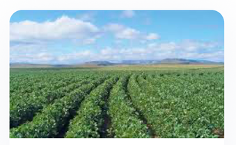
Figure 13: Cash Crop plantation
Geography
Soil

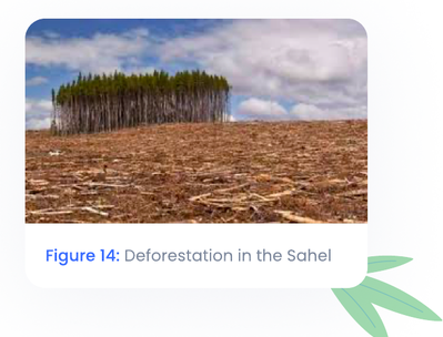
Deforestation
Occurs when large areas of forest are cut down, leaving a bare landscape. Forests are important as they offer protection from wind and rain erosion, the roots bind soil which prevents mass movement and soil erosion.
-
Trees, small bushes and scrub vegetation are cut down in the Sahel for firewood, building material and to make room for agriculture. In Mali, half a million hectares of trees have been cleared
-
The demand for wood in the Sahel has increased due to overpopulation
-
Trees are being cut down by the slash and burn method 30 times faster than they are being replaced
-
The timber is needed as a source of fuel or to build houses to house the increasing population
-
-
Trees are invaluable to the region as they act as barriers to prevent erosion
-
The leaf litter continuously fertilises the soil and more nutrients are added when the tree dies
-
Trees also absorb water during periods of heavy rainfall
-
-
The combination of overgrazing, overcropping and deforestation means the soil lacks nutrients that it needs for future farming. The land is abandoned and desertification spreads into the area
Geography
Soil

Figure 14: Deforestation in the Sahel
Soil Conservation
If managed properly, soil is a sustainable resource. There are methods to be used which can aid soil conservation. This type of human interaction with soil is positive.
Soil Conservation methods include:
- Stone lines
- Terracing
- Windbreaks/Shelter belts
Geography
Soil
Stone Lines
-
Burkina Faso, a country in the Sahel, suffers from very infrequent falls of heavy rain
-
In order to protect the soil, people place lines of small stones across slopes to lessen the impact of surface run-off
-
Rainwater gets trapped behind the stones, giving it a chance to soak into the ground before it hits the crops
-
Stone lines, therefore, replenish groundwater while reducing soil erosion
-
They work best on gentle slopes where they can increase crop yield by 50%
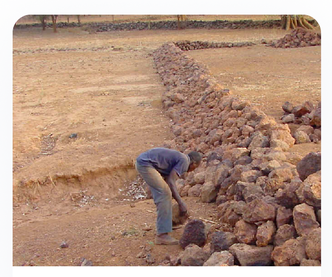
Figure 15: Stone lines
Soil
Terracing
-
A series of small walls are built along a hill slope, similar to steps of a stairs behind land that has been flattened and planted
-
A lip or a bund at the edge of each step traps water, allowing time for it to percolate (soak) into the soil
-
This prevents erosion and leaching by surface run-off
-
The building and maintenance of these terraces is labour intensive but are widely used in upland areas of China and Vietnam
-
They are a crucial form of soil conservation in these areas as they prevent monsoon rains from taking away soil in the region
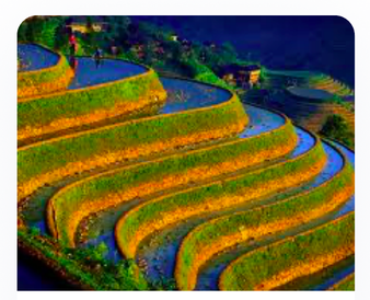
Figure 16: Terraces in China
Soil

Windbreaks/shelter belts
-
Windbreaks are an important form of soil conservation
-
They are barriers formed by trees and other plants with many leaves that are planted around the edges of fields on areas of high land that are exposed to wind
-
Windbreaks stop wind from blowing soil away and from damaging grain crops such as wheat
-
Windbreaks can protect areas up to 10 times the height of the tallest tree in the windbreak
-
In parts of the Sahel, studies have shown that grain harvests can be 20% higher on fields protected by windbreaks

500K+ Students Use These Powerful Tools to Master Soil For their Leaving Cert Exams.
Enhance your understanding with flashcards, quizzes, and exams—designed to help you grasp key concepts, reinforce learning, and master any topic with confidence!
66 flashcards
Flashcards on Soil
Revise key concepts with interactive flashcards.
Try Geography Flashcards49 questions
Exam questions on Soil
Boost your confidence with real exam questions.
Try Geography Questions13 exams created
Exam Builder on Soil
Create custom exams across topics for better practice!
Try Geography exam builder47 papers
Past Papers on Soil
Practice past papers to reinforce exam experience.
Try Geography Past PapersOther Revision Notes related to Soil you should explore
Discover More Revision Notes Related to Soil to Deepen Your Understanding and Improve Your Mastery