Photo AI
Last Updated Sep 26, 2025
Western Ireland Simplified Revision Notes for Leaving Cert Geography
Revision notes with simplified explanations to understand Western Ireland quickly and effectively.
338+ students studying
Geography
Region : Continental
Peripheral Region: Western Ireland
- Physical Processes
- Primary Economic Activities
- Secondary Economic Activities
- Tertiary Economic Activities
- Human Processes

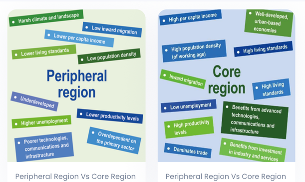
Figure 1: Core vs Periphery
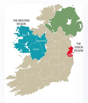
Figure 2: Sketch Map
Could be asked to draw a map of Ireland, marking out the regions or a sketch map of your region
Region: Continental

Layout
| Topic | Area of focus |
|---|---|
| Physical Factors | Climate, Soil, Relief and Drainage |
| Primary Economic Activities | Agriculture, Fishing |
| Secondary Economic Activities | Manufacturing |
| Tertiary Economic Activities | Tourism and Transport |
| Human Processes | Population Dynamics, Religion, Urban Development/ Growth of Kolkata |
Region: Continental
Physical Factors
Climate
- Cool temperate oceanic climate/maritime climate
- Atlantic Ocean influences this through the North Atlantic Drift
- When air moves over this current, the air is warmed and can gather moisture which is released over the Western Region
- South-Westerly winds move this moisture over the regions mountain ranges creating relief rainfall (warm air rises, cools, condenses and then drops its moisture)
- Frontal rainfall also occurs as warm and cold air masses meet, forcing the warm air to rise upwards, creating rainfall
- The region has higher than average rainfall as a result:
- 1,500mm – 2,500mm per year
- National average is 800mm – 1,250mm
- Temperatures average from 4°C -6°C in Winter and 15°C to 17°C in the summer
- There is a lot of cloud cover in the Western Region with average sunshine of 3.25 – 3.5 hours per day. National Average is 5 – 6.5

Geography
Region : Continental
Climate

Soils are varied but tend to be poor quality.
-
Leaching caused by heavy rainfall is a problem as nutrients are washed down through the soil, creating a hardpan. Water cannot pass through hardpans so waterlogging is a common issue in the region
-
Upland areas are generally made up of podzols. This type of soil has little humus and lacks nutrients as a result. It is found under coniferous trees and has been heavily leached. Areas mainly used for grazing sheep
-
Gleys are also common. They are waterlogged soil created due to the rainfall and a layer of impermeable Igneous or Metamorphic rock. More suitable to forestry than agriculture
-
Peaty Soils tend to be in upland areas that are difficult to access. If blanket bogs do exist, then they are difficult to reach and impossible to exploit commercially
-
Fertile Brown Soils are present in the region however they tend to be shallow. Mainly used for livestock as the lack of depth to the soil is of no benefit for agriculture
Relief and Drainage
- Western Region contains many upland areas created during the Caledonian Orogeny such as the Twelve Pins. These areas consist of underlying layers of Igneous and/or Metamorphic rock and are impermeable - soil is poorly drained.
Region : Continental
Lowland areas have been greatly affected by glaciation:
-
Glaciers removed most of the brown earth soil thousands of years ago leaving behind shallow, infertile, poorly draining soil such as boulder clay
-
When ice melted some areas were flooded – Killary Harbour in Galway is an example of a fjord (drowned U-shaped valley)
-
Drumlin belt in Clew Bay, Co. Mayo -gently rounded hills at intervals – also known as a 'basket of eggs' topography
-
Poor drainage as Drumlins interrupt normal water flow – deranged drainage pattern with marshy regions in between
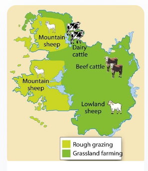
Figure 3: Agriculture in the Western Region - grazing dominates
Geography
Region : Continental

Primary Economic Activities
This involves the removal of natural resources from the land or sea. Regions that are mainly involved in primary economic activities tend to be poorer. As an economy develops, then the region progresses onto secondary and then tertiary.
A higher than average number of people work in the primary sector in the Western Region. For example, 24% of people in Roscommon work in this sector.
Agriculture
- Physical characteristics of the region limits farming as the harsh climate, poor soil and difficult landscape interferes with this activity
- Low levels of mechanisation due to the landscape also
- As a result, farming is small scale – small, fragmented farms with low yield
- 30% of farms are less than 10 hectares with 30% of farmers over 65 years old
- Up to 50% of farmers farm part time and earn extra money elsewhere
- Dairy farming and tillage are not widespread due to the poor soil – only 2.5% of the national barley crop is grown in this region
Region: Continental
-
Upland areas are mainly used for grazing sheep – as a result an estimated 27% of upland areas are overgrazed and suffer from soil erosion – further reduces productivity of farming
-
Grass is the most common crop grown and is used to feed livestock in the winter
-
Region has been categorised as a disadvantaged area by the EU and has begun to benefit from high farm subsidies (grants from our govt.) and grants from the EU called direct payments
-
EU's CAP (Common Agricultural Policy) has improved animal welfare and food quality – e.g. quotas, minimum price etc
-
REPS (Rural Environmental Protection Scheme) focuses on environmental conservation with farmers receiving grants to protect flora and fauna in rural areas
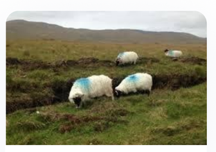
Figure 4: Grazing is most common in the Western Region
Geography
Region: Continental

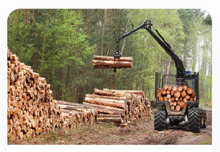
Forestry
-
Has become an important activity in upland and marginal areas, supported by Coillte (state-sponsored forestry company), the EU and private companies
-
Coniferous trees such as spruce and pine have been planted on 30,000 hectares of land across the Western Region with the support of Coillte
-
The climate is suited to this activity with mild year-round temperatures and rainfall meaning that coniferous trees in Ireland mature 5 times quicker than in Northern Europe
-
The Western Region also yields 50% more spruce trees than the east as the trees are not affected by the poor soil
-
The NDP has encouraged growth in this long-term investment industry as it creates employment, makes best use of the poor land and creates more profit than poorly paid, low yield sheep farming
- Farmers can earn up to €257 per acre a year for forestry
Region : Continental

Figure 5: Forestry in the Western Region
Fishing
-
A continental shelf is an area of shallower water just off the coast of a landmass – usually a rich breeding ground for fish
-
A continental shelf is an area of shallower water just off the coast of a landmass – usually a rich breeding ground for fish
-
Ireland's continental shelf extends for 320km off the western coast – one of the biggest in the world – there is a lot of plankton present which fish feed on
-
The water off the western coast is warmer (North Atlantic Drift), making it suitable for fish such as mackerel, cod and sole
-
Govt. has invested in ports and the industry in general through the NDP as some communities are dependant on the fishing industries
- 2,000 people are employed in this industry in the Western Region
Region : Continental
-
Selling processed fish generates more profit than fresh fish so the govt. is also hoping to expand the fish processing sector in the west of Ireland through further investment and retraining
-
The area is prone to overfishing due to fishing trawlers from other countries
-
Quotas and restrictions on fishing vessel size and equipment have been introduced to prevent this by the EU's CFP (Common Fisheries Policy)
- This has limited the expansion of this industry in the Western Region
-
Aquaculture (fish farming) is the main area of expansion in this industry and is common along sheltered bays
-
Farms in Clew Bay, Co. Mayo and Killary Harbour, Co. Galway employs around 400 people and produces large quantities of shellfish (mussels/oysters) and salmon
-
Aquaculture production has increased from 50,000 tonnes in 2000 to close to 200,000 tonnes today
Geography
Region: Continental
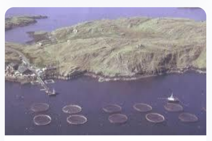
Figure 6: 'Real' map of Ireland including Continental Shelf

Figure 7: Fish Farming in Ireland
Geography
Region : Continental

Mining/Energy
-
In 1996, the Corrib gas field, a natural gas field, was discovered 70km off the coast of Mayo
-
It was hoped that this field would cover Irelands energy needs for 18 years with the gas being sold to Bord Gais for distribution around Ireland
-
Shell ENP (multi-national company) planned to build a pipeline to transport gas onshore from the Corrib field
-
This was met with many objections as the pipeline was planned to run through people's homes and farmland
- This tension reached crisis point in 2005 when protestors were arrested
-
Construction eventually got underway in 2006, being completed in 2015 – 12 years after the initial schedule and cost €800 million – 4 times the original estimated cost
- Late 2017 – Shell sold its shares with an overall loss of €900 million euro (covered by the new company)
-
See trailer for 'The Pipe' on Edmodo
Region : Continental

Figure 8: Planned Pipeline
Secondary Economic Activities
Raw Materials are processed or semi-processed materials are further developed. This processing takes place in manufacturing plants owned by Irish people or Multinational companies. In the Western Region, a lower than average number of people work in this sector.
Manufacturing Industries
Region: Continental
Less developed in this region than others – only 28% of people employed in the sector. Mainly due to its peripheral location. Many traditional companies closed down after our entry to the EU in 1973 as they couldn't compete with multinational companies. MNC's were hesitant to locate in the Western Region for a number of reasons:
Economic Factors:
-
Higher transport costs as the factories would be far away from main Irish and EU markets – road/rail/air networks not as well developed as other regions – only two motorways (M18/M6) and two small airports Shannon and Knock
-
Communication links not well developed -broadband access was limited
-
Electrical supply was lower/less reliable – important factor for energy-intensive industries
Human Factors:
- Widely dispersed population = low population density – 25 per km². Irish average is 60 per km². This makes it harder to choose where to locate a company as industries generally locate in areas of high population density which provide a workforce
Geography
Region : Continental
- Highly educated, younger people are moving out of the region which results in a brain drain. Younger people are moving to areas with greater economic opportunities with a higher standard of living. The region loses people with important skills, expertise and revenue from tax payments
Physical Factors:
-
Difficult to develop good infrastructure such as motorways/efficient rail networks when the landscape is rugged
-
There are very few large urban areas, bar Galway, so local markets tend to be small and not economically viable. Urban areas are important for companies that want to hire well-educated workers
-
The industries that have developed tend to be smaller scale and lack diversity
-
It has a high amount of labour-intensive traditional industries such as food or timber processing but these are prone to job losses due to factors such as mechanisation and rationalisation
- Major concern as 57% of manufacturing in Roscommon is in the food sector and wages are lower than the national average
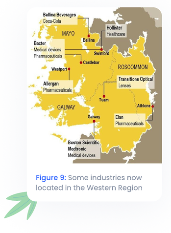
Galway:
- Exception to general trend of manufacturing in the Western Region
Region: Continental
-
Attracted modern growth industries with the help of the IDA who hope to increase Foreign Direct Investment by over 40% in the next 5 years, creating 80,000 more jobs in the process
-
Galway is home to Boston Scientific, one of the world's largest medical device companies – est. in 1994 in Galway, employs over 2,500 people in a modern, purpose built 37,000m² campus
-
The city is attractive to large MNC's (multi-national corporations) because of the size and quality of its labour force (NUIG)
-
Improvements to infrastructure (M18 and M6) have made it easier to access markets in other parts of the country
Addressing the issue:
-
Údarás na Gaeltachta works to attract industry to the region while the IDA (Industrial Development Agency) is responsible for development throughout Ireland
-
The Western Development Commission (WDC) was set up in 1997 to highlight weaknesses in the region and to spread industry more evenly throughout the West
-
NSS (National Spatial Strategy) 2002 – 2020 focused investment on cities and towns in the region, creating gateways (Galway) and Hubs (Tuam)
Gateway: Large urban areas invested in by the govt. to improve the area socially and economically
Hub: Smaller urban areas invested in by the govt. to improve the area socially and economically
Geography
Region : Continental
-
It aimed to make these areas more attractive for industries, improve communication/telecommunication links and develop industrial estates – used EU structural funds for education and training and regional funds for infrastructure
-
Hit worst by recession and suffered huge job losses and outward migration – e.g. 500 jobs lost when the Abbot medical devices factory in Galway closed down
Geography
Region : Continental

Tertiary Economic Activities
This sector involves the provision of services., e.g. doctors, teachers. Regions that are mainly involved in tertiary economic activities are generally richer. Therefore, a lower than average number of people are employed in this sector in the Western Region.
Tourism
-
Over 2 million visitors annually with 20,000 students attending Irish college every summer in Gaeltachts around the region
-
Attracted to the region for scenery (Connemara national park), fishing and boating (Lough Corrib), hillwalking (Mamturk mountains), cultural heritage (trad. music) and antiquities such as Dún Aonghasa on Inish Mór
-
Most tourists who come to the region stay in Galway and the industry is seasonal – busiest months in July/August which is helped by the Galway races and arts festival
-
Tourism is limited in the Western Region, made worse by the poor direct access to the area – new strategies are needed to improve this
-
NDP 2007 – 2013 encouraged niche holidays such as fishing, cultural and team-building trips
Region : Continental
-
Religious tourism could also be expanded further to maximise the potential from year-round trips to areas such as Knock or Croagh Patrick
-
The aim is to make tourism a year-round industry in the Western Region however further improvements to marketing and facilities such as accommodation are needed for this
-
Water quality in beaches also needs to be upgraded as two out of the seven beaches in Ireland that failed water quality standards in 2015 are located in Galway
-
The Wild Atlantic Way is a major initiative aimed at increasing tourism in the region
-
2,500km of coastal roads from Kinsale, Co. Cork to Co. Donegal
-
Promoting and marketing all aspects of the tourism industry in all counties on the West coast of Ireland from sport to culture to scenery
-
Using modern marketing skills appealing to all age groups - #wildatlanticway on Instagram, glamping, Star Wars sites etc
-
Region: Continental
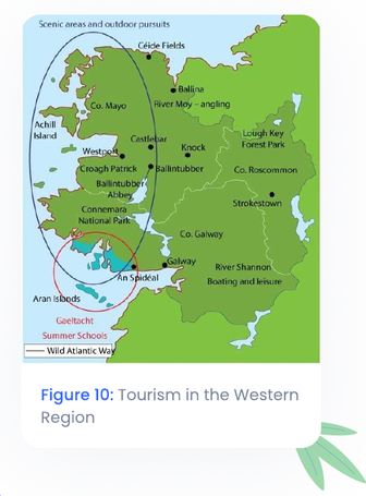
Figure 10: Tourism in the Western Region
Transport
-
Quality of roads is poor – few national primary roads. The best roads in the region are toll motorways –M6 and M18 – which connect Galway with Dublin and Ennis. Ennis to Galway motorway was recently completed – delayed by levels of investment, for example in 2005 Galway received one-fifth of the amount of money allocated to Dublin for transport development
-
Main shipping ports are in Galway and Sligo – limited economic value as they are isolated as a result of poor transport infrastructure. Unable to cater for large containers/international passenger travel/cruise ships
Geography
Region: Continental
-
Low population density (25 per km²) makes it difficult to develop and upgrade public transport services as they are not economically viable
-
Plans for an Atlantic Corridor linking Waterford to Donegal were abandoned in 2011 and replaced with the Planned National Roads Network 2020 after it was discovered that the government had not spent €500 million allocated to the Western Region under the NDP – money now spent on improving roads as part of Wild Atlantic Way initiative
-
Money was also to be invested in improving the Western Rail Corridor with rail lines being opened for both passenger and freight trains with the lobby group West on Track pushing for it. The rail line runs close to Knock airport and could also have been used to open the region to tourists.
- Govt. promised to open Atheny-Tuam by 2011 and Claremorris-Tuam by 2015. Both were delayed until 2018 – earlier this year plans were delayed further due to worries that the rail line would not be economically viable
Geography
Region : Continental

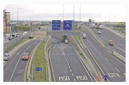
Figure 11: Road in the core Dublin region
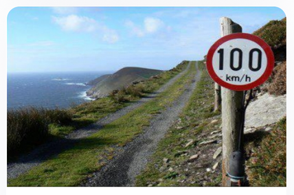
Figure 12: Road in the Western Region (not a typical road)

Region : Continental

Human Processes
Population Dynamics
-
Population of the Western Region changed dramatically since 1841. Population was 850,000 – emigration and death due to the Famine started a constant decrease until the 1970's when 312,000 people remained in the region
-
During Celtic Tiger era (1990's) people moved to urban areas in search of work – population in certain areas increased. Meat processing plants opened in Gort, Co. Galway which saw an influx of Brazilian migrants
-
Population now stands at 445,356 with two-thirds living in rural areas. Average population density is 25 per km² however due to the physical landscape, the population is not spread evenly throughout the region – in coastal areas where fishing and tourism industries are present the population density can rise to 160 per km²
-
The region has low marriage rates and low birth rates – younger people leaving in search of work and a better standard of living. Outward migration in the Western Region could be called 'age selective' as the vast majority of people leaving are young
Region: Continental
Geography
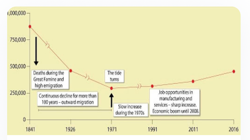
Figure 13: Population change in the Western Region
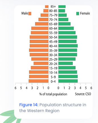
Figure 14: Population structure in the Western Region
Region: Continental
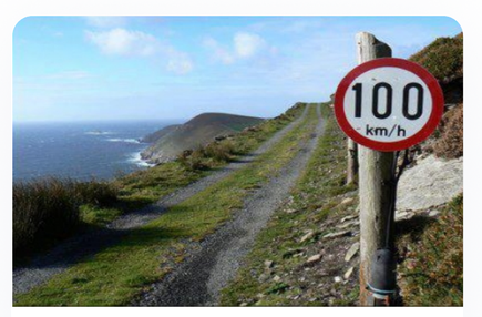
Figure 15: Distribution of Population in the Western Region
Language
-
Largest Gaeltacht – Connemara – is located in the Western Region, covering 800km²
-
In 1841 35,000 people lived here – has now fallen to 10,500
-
Connemara West was set up in 1971 to help the area economically and socially and try to prevent rural depopulation. Connemara Community Radio and Teach Ceoil (a centre for trad. music) were established however the organisation has had a limited effect
Region : Continental
Urban/Rural Development
> Urban:
-
Population of urban areas has greatly increased since 2002 eg Galway – population of 75,529. Attracted to the city for work and education
-
Castlebar in Mayo is another example – population of 12,000. Dept. of Agriculture is located here and created lots of jobs as part of an expanding services sector
> Rural:
-
Rural depopulation is a major issue with people moving to towns to search for work – less people left to run farms
-
Only one of our 7 universities are located in the region (NUIG) and only 13% of graduates gain employment in the region. This leads to a brain drain in the area as the highly educated, economically active age group look for work in other regions
-
Outward migration lowers population density and majorly affects services – e.g. closure of rural post offices and amalgamation of primary schools
Geography
Region : Continental
-
High age dependency ratio in the Western Region (more people above 65 and below 15 than there is economically active) as younger people leave in search of work which adds to the ageing population profile of the Western Region
-
NDP is focused on sustainable rural development – protect resources, amenities and attractiveness of the area for the benefit of locals
-
Funds have been used to improve local services such as childcare facilities whilst grants have been given to farmers for waste management and modernisation of resources and practices

500K+ Students Use These Powerful Tools to Master Western Ireland For their Leaving Cert Exams.
Enhance your understanding with flashcards, quizzes, and exams—designed to help you grasp key concepts, reinforce learning, and master any topic with confidence!
60 flashcards
Flashcards on Western Ireland
Revise key concepts with interactive flashcards.
Try Geography Flashcards6 quizzes
Quizzes on Western Ireland
Test your knowledge with fun and engaging quizzes.
Try Geography Quizzes55 questions
Exam questions on Western Ireland
Boost your confidence with real exam questions.
Try Geography Questions13 exams created
Exam Builder on Western Ireland
Create custom exams across topics for better practice!
Try Geography exam builder47 papers
Past Papers on Western Ireland
Practice past papers to reinforce exam experience.
Try Geography Past PapersOther Revision Notes related to Western Ireland you should explore
Discover More Revision Notes Related to Western Ireland to Deepen Your Understanding and Improve Your Mastery