Photo AI
Last Updated Sep 26, 2025
Isostasy Simplified Revision Notes for Leaving Cert Geography
Revision notes with simplified explanations to understand Isostasy quickly and effectively.
447+ students studying
Rivers
Isostasy
Key Words:
| Term | Definition |
|---|---|
| Eustatic Movement | A change in sea level |
| Isostatic Uplift/Adjustment | The crust of the Earth lifting up |
| Incised | To cut deeper |
| Rejuvenation | To make young again |
| River's Base Level | Lowest level that a river/stream can erode it's channel to |
| Peneplains | Areas of flat land |
Geography
Rivers

Areas of focus:
-
What is Isostasy and Base Level?
-
Adjustments to Base Level: Evidence of rejuvenation
- Knickpoints
- Incised Meanders
- Paired Terraces
- Raised Beaches
-
Cyclic Landscape Development and Peneplains
Common topics on the exam:
-
Everything
-
Focus on examples of four landforms listed above with reference to all other parts of Isostasy – what it is, base level and cyclic landscape development
Geography
Rivers

What is Isostasy?
-
Isostasy refers to the balance between the Earth's crust rising and sinking due to the adding or removing of weight
-
The lithosphere (solid part of crust) sits on top of the asthenosphere (semi-molten upper mantle) with the thicker parts of the asthenosphere deeper than the thinner parts. This creates a balance known as isostatic equilibrium
-
During the last ice age, the Earth's crust had the extra weight of ice sitting on top of it which forced it down deeper into the asthenosphere in certain parts. When this happens it is called isostatic readjustment
-
When this ice age ended, the weight was lifted as the ice melted, and the crust floated back to its original position. This is known as isostatic adjustment or isostatic uplift
-
Isostatic processes can lead to a change in sea level (eustatic movement) when the weight of glacial ice causes the earth's crust to sink
-
The effect of isostasy can be seen on both fluvial and coastal features
Geography
Rivers

Figure 1: Isostasy
Figure 2: Landscape Cycle
Base Level
-
Isostatic processes affect a river's base level (lowest level a river can erode its channel to – generally equal to sea level)
-
When the weight of glacial ice is removed, land rises. This means that rivers are now flowing down a steeper slope giving it more energy to erode
-
This can occur in the mature/old age stage of a river and is known as 'rejuvenation' whereby the river is made young again
-
The river forms a new, lower river profile
Geography
Rivers

Evidence of Rejuvenation
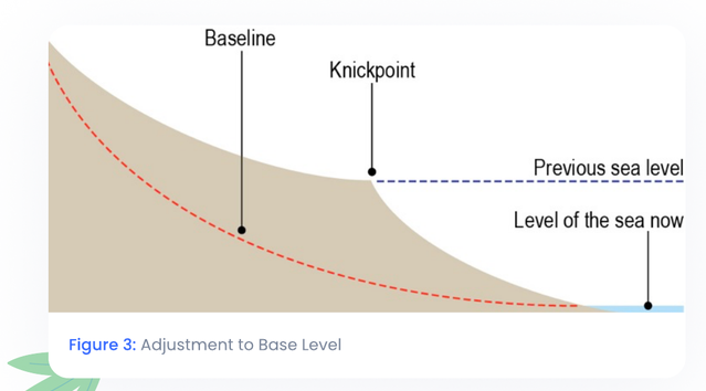
Knickpoints
Example: Kathleen's Falls, River Erne, Co. Donegal
Processes: Rejuvenation (Vertical and Headward Erosion)
-
A knickpoint is a sudden drop in the river's profile, usually marked by a waterfall
-
Rejuvenation begins at the rivers mouth as the sea level drops. Vertical erosion is increased and the river cuts a deeper valley as a result
-
The old river profile is altered through headward erosion, creating a new one. The place where the old river profile meets the new one is called a knickpoint and is evidence of the river becoming young again (rejuvenation)
-
Knickpoints are cyclical and can develop more than once on a rivers course
Geography
Rivers

Figure 4: Knickpoints
Incised Meanders
Example: River Barrow, Co. Carlow
Processes: Rejuvenation (vertical erosion)
-
Once it is rejuvenated, a river will erode vertically again, like in the old age stage
-
Incised meanders are created when a meandering river valley erodes vertically into its floodplain
-
They are very deep with really steep sides and can be seen on an OS map through tightly packed contour lines along a meandering river
Rivers

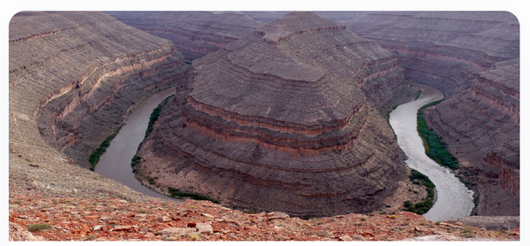
Figure 5: Incised Meander

Figure 6
Rivers
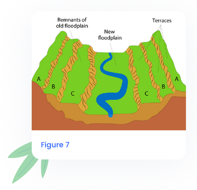
Paired Terraces
Example: River Barrow
Processes: Rejuvenation (vertical, lateral erosion)
- These are the remains of a former floodplain
- Vertical erosion cut a deeper channel into the riverbed when rejuvenation occurred
- This channel was then widened by lateral erosion and the work of meanders. Sediments were deposited during times of flood
- Overtime, new floodplains were created at a lower level than before
- The former floodplain is left high on the valley sides at equal heights – paired terraces
- Rivers can have more than one example of paired terraces depending on how often rejuvenation has occurred
Rivers
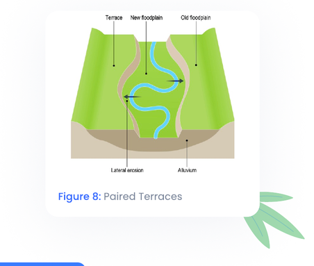
Figure 8: Paired Terraces
Raised Beaches
Example: Donegal Bay
Processes: Rejuvenation (Coastal Erosion)
- Raised beaches are found high above the present sea level
- Formed when a glacier compressed and weighed down part of the landmass.
- When the ice melted, the pressure exerted by the glacier was released and the land surface rose back up towards its previous level
- New beaches are created below the raised beach as the sea starts to erode the newly uplifted land.
- The raised beach marks the level the sea reached before the land was uplifted
- Raised cliffs and caves are also formed in the same way
Rivers
Geography

Figure 9: Raised Beaches

Figure 10: Raised Beach in Devon, England
Geography
Rivers
Cyclical Landscape Development
Landscape Development is cyclical. It happens in three main stages:
Early Stage:
- The landscape is flat to begin with
- It quickly becomes high and rugged through the tectonic process of folding
- Mountains are created
Middle Stage:
- Vertical erosion begins to shape the landscape as streams and rivers carve out valleys
- Floodplains are created through lateral erosion as the valleys become flatter
- The angle of slope decreases constantly throughout this cycle as the landscape becomes flatter towards the sea
Late Stage:
- Lateral Erosion, Mass Movement and Deposition combine to form peneplains (areas of flat land).
- No more erosion can take place at this stage
- The base level has been reached

Rivers
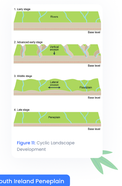
Figure 11: Cyclic Landscape Development
The South Ireland Peneplain
-
Covers hundreds of square kilometres in Co. Waterford and Co. Cork
-
Best example can be seen in the Knockmealdown Mountains with the height of land varying between 180m and 240m above todays sea level
Geography
Rivers

-
Formed on the sandstone uplifted during the Armorican folding and consists of a reasonably flat landscape with some individual hills
-
The sandstone was worn down to a peneplain by an ancient river system
-
The peneplain was later submerged beneath the sea where layers of limestone and chalk were formed over it
-
Later uplift brought the land back above sea level again
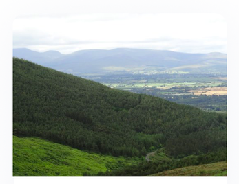
Figure 12: Munster Peneplain
Geography
Rivers

Exam Questions
Isostasy
- Describe and explain how isostasy impacts on the coastal landscape or on the fluvial landscape.
Fluvial Adjustment
- Examine how changes in base level impact on geomorphic processes and landforms in a fluvial environment.
Isostacy
- Examine how Isostacy has impacted on the Irish landscape.
Fluvial Adjustment
- Explain how rivers adjust to a change in base level, using examples that you have studied.
Isostatic Changes
- Explain how isostatic changes have impacted on the Irish landscape, using examples that you have studied.
Landform Development
- Isostatic processes involve adjustments to the balance between land and sea. Discuss how these processes have shaped the Irish landscape over time.

500K+ Students Use These Powerful Tools to Master Isostasy For their Leaving Cert Exams.
Enhance your understanding with flashcards, quizzes, and exams—designed to help you grasp key concepts, reinforce learning, and master any topic with confidence!
60 flashcards
Flashcards on Isostasy
Revise key concepts with interactive flashcards.
Try Geography Flashcards48 questions
Exam questions on Isostasy
Boost your confidence with real exam questions.
Try Geography Questions13 exams created
Exam Builder on Isostasy
Create custom exams across topics for better practice!
Try Geography exam builder47 papers
Past Papers on Isostasy
Practice past papers to reinforce exam experience.
Try Geography Past PapersOther Revision Notes related to Isostasy you should explore
Discover More Revision Notes Related to Isostasy to Deepen Your Understanding and Improve Your Mastery