Locating Places on Maps (Grade 10 NSC Matric Geography): Revision Notes
Locating Places on Maps
Understanding map location systems
Geographers need precise methods to describe where places are located on Earth. Maps use special systems to help us pinpoint exact locations, whether we're looking at a small area like a school campus or finding towns and cities across the country.
Map location systems are fundamental tools in geography that allow us to communicate precise locations using standardized methods. These systems make it possible for anyone, anywhere in the world, to find the exact same location using the same reference information.
There are two main ways to locate places on maps: grid reference systems and coordinate systems using latitude and longitude.
Grid reference systems
Alphanumeric grid systems
The simplest way to locate places on maps uses a combination of letters and numbers, called an alphanumeric system. This system divides a map into squares using:
- Letters running vertically (up and down the sides)
- Numbers running horizontally (across the top and bottom)
Each square on the map gets a unique reference by combining its letter and number. For example, if you want to find Room 19 in a school, you might discover it's located in grid square A6.
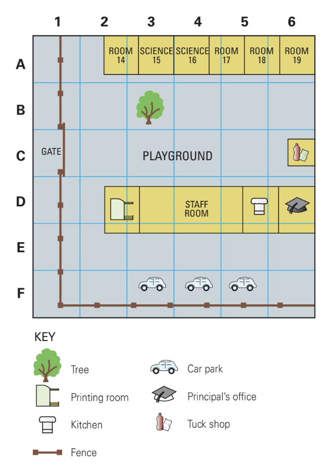
Practical Example: Finding a Location
If you're looking for the library on a school campus map:
- Find the library building on the map
- Look at which grid square it falls within
- Read the letter from the vertical axis (e.g., "B")
- Read the number from the horizontal axis (e.g., "4")
- The library is located in grid square B4
This grid system works well for:
- School campus maps
- Street atlases
- Local area maps
- Any situation where you need to give someone general directions to an area
Reading grid references
When using grid references, you always read the letter first, then the number. This helps create a standard system that everyone can understand. The grid square tells you the general area where something is located, but it doesn't give you the exact precise position within that square.
Critical Rule: Letter First, Number Second
Always remember the sequence: Letter → Number. This is a universal standard in grid reference systems. Reading in the wrong order (number first, then letter) will lead you to completely the wrong location!
Exact position using coordinates
Latitude and longitude basics
For more precise location work, geographers use a global system called latitude and longitude coordinates. This system creates an invisible grid across the entire Earth's surface using imaginary lines:
- Latitude lines run horizontally around the Earth (east to west)
- Longitude lines run vertically around the Earth (north to south)
These coordinate lines are measured in degrees (°), and they allow us to pinpoint any location on Earth with great accuracy.
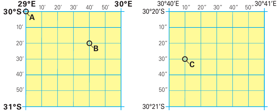
Think of latitude and longitude as creating a global address system. Just like your home has a street address that uniquely identifies where you live, every point on Earth has coordinate "address" that precisely identifies its location using this invisible grid system.
Degrees, minutes and seconds
To make coordinates even more precise, each degree is broken down into smaller units:
- 1 degree = about kilometres of distance on the ground at the Equator
- 1 minute = about kilometres of distance on the ground
- 1 second = about metres of distance on the ground
The system works like this:
- Each degree is divided into 60 minutes (written as ')
- Each minute is divided into 60 seconds (written as ")
This means you can describe a location very precisely. For example, instead of just saying a place is at 30°S and 29°E, you could say it's at 30°20'30"S and 29°40'10"E.
Understanding Coordinate Precision
Imagine you're standing at a specific point:
- Degree level: - This places you somewhere within a km area
- Minute level: - This narrows it down to approximately a km area
- Second level: - This pinpoints you to within about a metre area
Reading coordinates precisely
When writing coordinates, always follow this format:
- Latitude first (how far north or south), then longitude (how far east or west)
- Include the direction letters: N, S, E, W
- Write degrees, then minutes, then seconds
Coordinate Format Standard
The correct format is: Latitude, Longitude
- Correct: 28°26'59"S, 21°16'01"E
- Incorrect: 21°16'01"E, 28°26'59"S
Always include direction indicators (N, S, E, W) to avoid confusion about which hemisphere you're referring to.
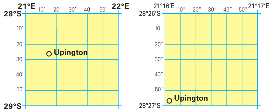
Looking at the example of Upington, the town can be located at approximately 28°26'S and 21°16'E. For even greater precision, you could describe it as 28°26'59"S and 21°16'01"E.
Practical applications
Working with topographic maps
Professional topographic maps, like the 1:50,000 scale map extract, combine both grid systems and coordinate systems. These detailed maps show:
- Precise coordinate references along the edges
- Grid squares for general reference
- Detailed geographic features
- Elevation information
- Settlement patterns
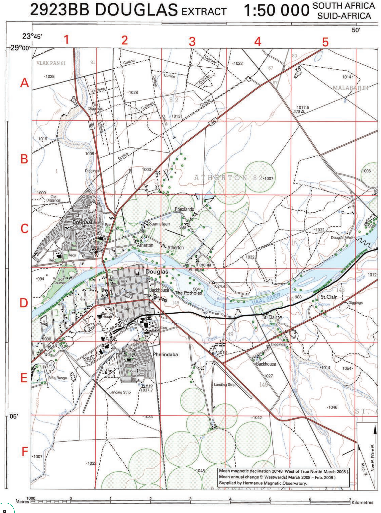
When working with these maps, you can use either the grid square system for general location work or the precise coordinates for exact positioning.
Topographic maps are like having both a general street directory and a precision GPS system in one document. The grid squares help you quickly navigate to the right general area, while the coordinates allow you to pinpoint exact locations when precision is essential.
Why precision matters
Different situations require different levels of location accuracy:
- Grid squares are perfect for giving general directions or identifying areas
- Degree coordinates work well for locating towns and cities
- Minutes and seconds are essential for scientific work, surveying, and navigation
The more precise your location system, the smaller the area you're describing. This is particularly important for:
- Emergency services finding exact locations
- Scientists recording research sites
- Navigation systems in vehicles
- Archaeological and geological surveys
Tips for success
When working with map location systems:
- Practice reading coordinates in the correct order (latitude first, then longitude)
- Remember the distance relationships - degrees are large areas, seconds are very small
- Check your direction indicators - make sure you include N/S and E/W
- Use the appropriate system - simple grid references for general areas, coordinates for precise locations
- Double-check your readings- small errors in coordinates can put you kilometres away from your intended location
Key Points to Remember:
- Grid reference systems use letters and numbers to identify squares on maps - simple but effective for general locations
- Coordinate systems use latitude and longitude with degrees, minutes, and seconds for precise positioning anywhere on Earth
- One degree equals approximately 111 kilometres - this helps you understand the scale you're working with
- Always read latitude first, then longitude when giving coordinates
- Choose the right system for your needs - grid squares for general areas, precise coordinates for exact locations