Urban Climate (AQA A-Level Geography): Revision Notes
Urban climate
What is an urban microclimate?
Cities create their own unique atmospheric conditions that differ significantly from the surrounding countryside. These local variations in weather patterns are known as an urban microclimate.
An urban microclimate refers to the small-scale variations in temperature, precipitation, humidity, wind speed and evaporation that occur within a particular urban environment.
The effects of urbanisation on local climate extend both upwards into the atmosphere and downwards towards the ground surface. These changes can be measured across multiple weather elements, making urban areas distinctly different from nearby rural locations.
How urban areas affect local climate
Urban environments modify local atmospheric conditions in several important ways. The table below summarises the key differences between urban and rural climates:
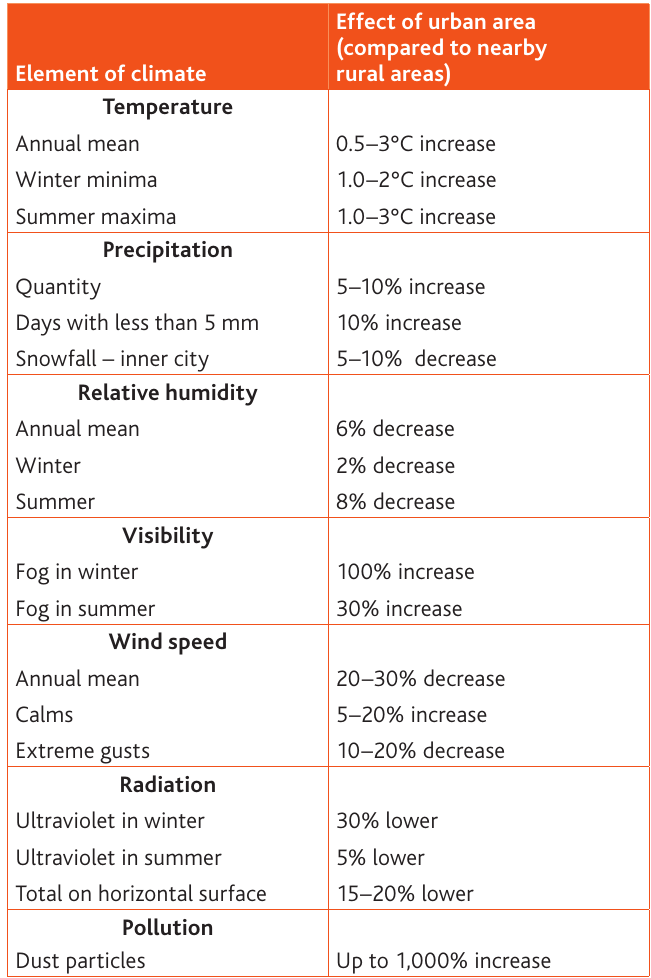
The table demonstrates that urbanisation affects every aspect of local climate, with some changes being quite dramatic - particularly in pollution levels and visibility conditions.
Let's examine each of these climate elements in detail:
Temperature
Cities are notably warmer than surrounding rural areas:
- Annual mean temperatures are 0.5-3°C higher in urban areas
- Winter minimum temperatures can be 1.0-2°C warmer
- Summer maximum temperatures show increases of 1.0-3°C
These temperature increases are caused by heat absorption by buildings and roads, reduced cooling from vegetation, and waste heat from human activities.
Precipitation
Urban areas tend to receive more rainfall:
- Total precipitation quantity increases by 5-10%
- The number of days with light rain (less than 5mm) increases by 10%
- Snowfall in inner city areas decreases by 5-10%
The additional rainfall occurs because rising warm air over cities creates convection currents that promote cloud formation and precipitation.
Relative humidity
The air in cities is generally drier:
- Annual mean relative humidity decreases by 6%
- Winter sees a 2% decrease
- Summer experiences an 8% decrease
Lower humidity results from faster water runoff on impermeable surfaces and reduced evapotranspiration due to less vegetation.
Visibility
Urban areas experience reduced visibility:
- Winter fog increases dramatically by 100%
- Summer fog increases by 30%
Poor visibility is caused by increased air pollution, which provides condensation nuclei for fog formation.
Wind speed
Cities significantly reduce wind speeds:
- Annual mean wind speed decreases by 20-30%
- Calm conditions increase by 5-20%
- Extreme gusts decrease by 10-20%
Buildings create friction that slows down wind, though wind can be channelled and accelerated through street canyons.
Radiation
Urban areas receive less solar radiation:
- Ultraviolet radiation in winter is 30% lower
- Summer UV radiation decreases by 5%
- Total radiation on horizontal surfaces is 15-20% lower
Air pollution and dust particles scatter and absorb incoming solar radiation before it reaches the ground.
Pollution
Cities experience dramatically higher pollution levels:
- Dust particles can increase by up to 1,000%
This massive increase results from vehicle emissions, industrial activities, and construction work.
The urban heat island effect
One of the most significant features of urban climates is the urban heat island (UHI) effect.
An urban heat island is the zone around and above an urban area that experiences higher temperatures than the surrounding rural areas.
Cities with populations of one million or more can be 1-3°C warmer than their surroundings on average. On clear, calm days, this temperature difference can reach as much as 12°C.
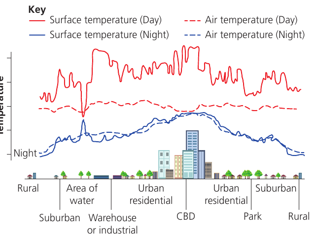
The diagram above illustrates how temperatures vary across different urban zones:
- Rural areas: Lowest temperatures, providing the baseline for comparison
- Suburban areas: Moderate temperature increases as built-up areas begin
- Areas of water: Temperature drops due to water's high heat capacity and cooling effect through evaporation
- Warehouse/industrial areas: Significant temperature increases from large buildings and impermeable surfaces
- Urban residential areas: Elevated temperatures from housing density and reduced vegetation
- CBD (Central Business District): Highest temperatures due to tall buildings, extensive concrete and asphalt surfaces, and concentration of human activities
- Parks: Temperature decreases where vegetation provides cooling through evapotranspiration
Day and night temperature patterns
The urban heat island effect varies throughout the day:
Day vs Night Temperature Patterns
Daytime: Surface temperatures are highest in urban areas, particularly over dark surfaces like roads and roofs. Air temperatures also increase but the difference is less pronounced.
Night-time: The temperature difference becomes more significant. Urban surfaces release stored heat slowly throughout the night, keeping air temperatures elevated. Rural areas cool more rapidly, creating the greatest temperature contrast between city and countryside.
Factors influencing the urban heat island
Several factors contribute to higher urban temperatures:
- Surface materials: Concrete, brick and asphalt absorb and store heat more effectively than vegetation and soil
- Reduced vegetation: Less evapotranspiration means less cooling
- Building geometry: Tall buildings trap heat and reduce cooling by wind
- Waste heat: Heating systems, air conditioning, vehicles and industrial processes release heat
- Reduced sky view: Buildings block the loss of heat to the night sky
Smaller urban areas also produce heat islands, though the effect tends to decrease as city size decreases.
Urban atmospheric structure
The urban atmosphere has a distinctive layered structure that differs from rural areas.
The urban canopy layer
The urban canopy layer (UCL) is the layer of air closest to the ground surface, extending upwards to the mean building height. This is where people live and work, and where the most direct effects of urbanisation on climate are experienced.
The urban boundary layer
Above the urban canopy layer sits the urban boundary layer (UBL). This layer can extend over one kilometre in height during the daytime, though it shrinks to just a few hundred metres at night.
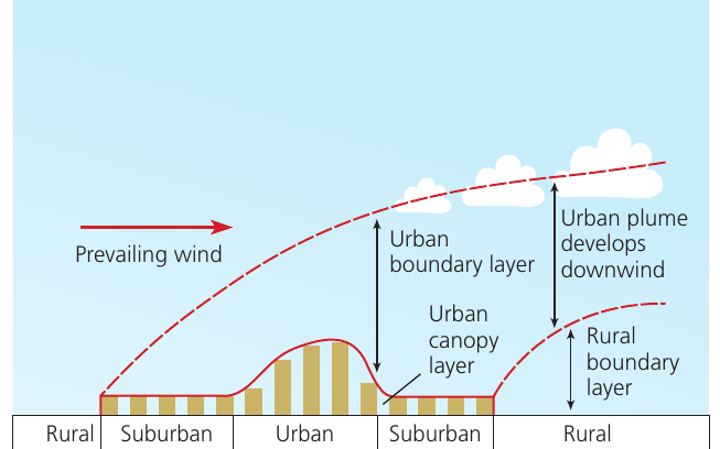
The diagram shows how these layers interact with prevailing winds to create an urban climate dome. Warm air rises over the city, creating a plume of warmer air that extends downwind from the urban area. This circulation pattern helps to distribute urban-generated heat and pollution across a wider area.
Air pollution and other key concepts
Albedo
Albedo is the reflectivity of a surface, expressed as the ratio between incoming solar radiation (insolation) and the amount of energy reflected back into the atmosphere.
Light-coloured surfaces have a high albedo and reflect more solar radiation, staying cooler. Dark surfaces have a low albedo and absorb more heat, contributing to the urban heat island effect. Urban areas typically have lower albedo than rural areas due to dark road surfaces and roofs.
Particulate air pollution
Particulate air pollution is caused by the release of tiny particles and harmful gases into the atmosphere. While some particles occur naturally, urban particulate pollution is largely caused by burning fossil fuels.
Vehicle exhausts, industrial emissions and construction activities all contribute to particulate pollution in cities. These particles can cause respiratory problems and reduce visibility.
Photochemical pollution
Photochemical pollution is a form of air pollution that occurs mainly in cities and can be dangerous to health. It forms when exhaust fumes become trapped by temperature inversions and react with sunlight to create low-level ozone and other harmful gases.
This type of pollution is associated with high-pressure weather systems that bring clear skies and calm conditions. The sunlight triggers chemical reactions in the trapped pollutants, creating the characteristic smog seen in some cities.
Temperature inversion
A temperature inversion is an atmospheric condition where temperature increases with height, rather than decreasing as normal. This prevents convection and traps pollution in the lower atmosphere.
Normally, air temperature decreases as you go higher in the atmosphere. During a temperature inversion, a layer of warmer air sits above cooler air near the ground. This stable situation prevents the normal mixing of air, trapping pollutants close to the surface where people live and work.
Remember!
Key Points to Remember:
-
Urban areas create distinctive microclimates with temperatures 0.5-3°C warmer than surrounding rural areas, and potentially up to 12°C warmer on clear, calm days.
-
Cities experience significant changes across multiple climate elements: increased precipitation and pollution, decreased humidity and wind speed, and reduced solar radiation reaching the surface.
-
The urban heat island effect is strongest in the CBD where buildings are tallest and surface materials store the most heat, with temperatures dropping over parks and water bodies.
-
The urban atmosphere has two main layers: the urban canopy layer (UCL) near the surface up to building height, and the urban boundary layer (UBL) above it that can extend over 1 kilometre high during daytime.
-
Urban areas concentrate various forms of air pollution, including particulate matter from combustion and photochemical smog, which can be trapped near the surface by temperature inversions.