The Thames Basin (OCR GCSE Geography B (Geography for Enquiring Minds)): Revision Notes
The Thames Basin
Introduction to the Thames Basin
The Thames Basin is one of the UK's most important geographical regions, centred around the River Thames. This distinctive landscape in southern England has shaped human settlement patterns for centuries and continues to influence where and how millions of people live today. The basin encompasses a variety of rock types and landforms that have created unique challenges for water supply in one of Britain's most populated areas.
The Thames Basin's significance extends far beyond its physical geography – it has been central to British history, economy, and culture for thousands of years, supporting major population centres and driving economic development.
Key geographical features
The River Thames dominates this landscape, stretching an impressive 346 kilometres from its source to where it meets the sea. The river begins its journey in the Cotswold Hills, a range of limestone hills in south-west England, before flowing in a generally eastward direction towards the North Sea. This lengthy course takes the Thames through several major urban centres, making it a vital waterway for transport, settlement, and water supply.
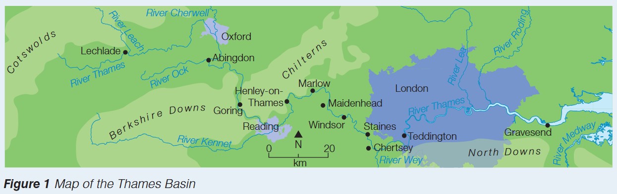
Along its route, the Thames passes through three particularly significant cities. Oxford, known for its historic university, sits in the upper reaches of the river. Further downstream lies Reading, an important commercial centre. The river then flows through the heart of London, Britain's capital city, before continuing east to the Thames Estuary and eventually the North Sea.
The Thames Basin holds the distinction of being the most densely populated river basin in the entire United Kingdom. Approximately 13 million people live within this river catchment area, creating enormous pressure on the region's natural resources, particularly water. This concentration of population has important implications for water management and supply.
The extremely high population density in the Thames Basin – 13 million people – creates unprecedented pressure on water resources. This makes the basin's geology and water management systems absolutely critical for supporting such a large population in Britain's driest region.
Underlying geology and rock types
The geological structure of the Thames Basin plays a crucial role in shaping both the landscape and water resources of the region. While the River Thames flows predominantly over clay deposits, the wider basin contains a variety of rock types that influence how water moves through and is stored within the landscape.
One of the most significant geological features is the presence of chalk beneath much of the basin. Chalk is a soft, white limestone rock that has an important characteristic: it is permeable. This means water can pass through it, unlike clay which is impermeable and prevents water movement. The chalk forms what geologists call an aquifer – an underground layer of rock that can store and transmit water.
Understanding Permeability
The difference between permeable and impermeable rocks is fundamental to understanding water resources:
- Permeable rocks (like chalk) have tiny spaces between their particles that allow water to flow through
- Impermeable rocks (like clay) have particles packed so tightly that water cannot pass through
This property determines whether rocks can store and supply groundwater.
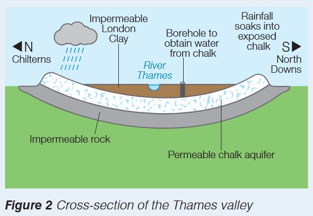
The cross-section of the Thames valley reveals how different rock layers are arranged. At the surface, particularly around London, sits a layer of impermeable London Clay. This clay prevents rainwater from soaking straight down into the ground. Beneath this clay layer lies the permeable chalk, which acts as a natural underground reservoir. Below the chalk sits another layer of impermeable rock, which stops water draining away too deeply. This sandwich-like arrangement of impermeable-permeable-impermeable rocks creates ideal conditions for storing groundwater.
The "sandwich" structure of the Thames Basin geology is crucial for water storage:
- Top layer: Impermeable London Clay (seals water in)
- Middle layer: Permeable chalk aquifer (stores water)
- Bottom layer: Impermeable rock (prevents water escaping downward)
Without this specific arrangement, London's groundwater supply would not exist.
The chalk layers are exposed at the surface in the surrounding hills – the Chilterns to the north and the North Downs to the south. When rain falls on these exposed chalk areas, the water can soak into the rock and gradually flow underground towards the centre of the basin beneath London.
London's water supply challenges
South-east England faces a unique water supply challenge: it is the driest region in the United Kingdom. Despite this, it supports the largest concentration of population and economic activity in the country. This combination of low rainfall and high population creates significant pressure on water resources.
The River Thames alone cannot meet the water demands of London and the surrounding region. The volume of water flowing in the river is insufficient to supply the millions of people, businesses, and industries that depend on it. This shortfall means alternative water sources must be found to maintain adequate supply.
Critical Water Supply Challenge
London faces a paradox: the UK's driest region supporting the UK's largest population. The Thames River cannot supply enough water on its own, making groundwater extraction absolutely essential for the city's survival and growth.
Groundwater provides a crucial solution to this problem. London obtains approximately 40% of its water from groundwater sources – water stored underground in permeable rock layers. This represents a substantial proportion of the city's total water supply and demonstrates the importance of underground water resources in this region.
To access this underground water, boreholes are drilled down through the impermeable clay layer at the surface. These boreholes penetrate deep enough to reach the chalk aquifer beneath. Once the boreholes reach the permeable chalk, water can be pumped up from the aquifer to the surface, where it is treated and distributed to homes and businesses.
How Boreholes Work
The process of extracting groundwater through boreholes involves:
- Drilling through the impermeable London Clay layer at the surface
- Continuing down until the drill reaches the permeable chalk aquifer
- Installing pumping equipment to bring water to the surface
- Treating the water to ensure it meets drinking water standards
- Distributing the water through the supply network
This system allows London to tap into the vast underground water reservoir stored in the chalk.
The chalk aquifer system works through a process of natural recharge. Rainwater that falls on the exposed chalk hills (the Chilterns and North Downs) soaks into the permeable rock. This water then moves slowly through the chalk towards the centre of the basin. The geological structure acts like a large underground storage system, with the impermeable rocks above and below the chalk preventing the water from escaping. This stored water can then be extracted through boreholes as needed.
This groundwater extraction from the chalk aquifer is essential for meeting London's water demands. Without access to these underground water resources, the city would face severe water shortages, particularly during dry periods when river flows are low. The geology of the Thames Basin, therefore, directly influences the ability of millions of people to access reliable water supplies.
Key Points to Remember:
-
The River Thames flows 346 kilometres from the Cotswold Hills to the North Sea, passing through Oxford, Reading, and London
-
The Thames Basin is the UK's most densely populated river basin, home to 13 million people
-
The basin's geology includes both impermeable clay and permeable chalk rocks, with the chalk forming an important aquifer beneath London
-
South-east England is the driest region in the UK, creating water supply challenges for its large population
-
London obtains 40% of its water from groundwater extracted through boreholes drilled into the chalk aquifer beneath the city
-
The sandwich structure of impermeable-permeable-impermeable rocks creates ideal conditions for storing and accessing groundwater