Extreme Precipitation (OCR GCSE Geography B (Geography for Enquiring Minds)): Revision Notes
Extreme Precipitation
What affects precipitation around the world?
Precipitation refers to water that falls from the atmosphere in various forms, including rain, sleet, snow, or hail. The distribution of precipitation across the globe is not uniform, and several factors operating at different scales influence where and how much precipitation falls.
Global scale factors
The global circulation system plays a crucial role in determining precipitation patterns worldwide. This system creates distinct pressure zones that directly influence rainfall distribution.
Understanding Pressure and Precipitation
There is a critical relationship between atmospheric pressure and precipitation:
- Low pressure = Rising air = Wet conditions
- High pressure = Sinking air = Dry conditions
This fundamental principle explains precipitation patterns across the globe.
Low pressure zones are characterised by rising air. As air rises, it cools and condenses, leading to cloud formation and high levels of precipitation. These areas tend to be wet.
High pressure zones experience sinking air. As air descends, it warms up and can hold more moisture, preventing cloud formation. These areas remain dry.
When warm air and cool air meet, frontal rainfall occurs. The warmer, lighter air is forced to rise over the cooler, denser air. As the warm air rises and cools, condensation takes place, producing rainfall along the frontal boundary.
In areas where insolation (incoming solar radiation) is intense, the air becomes warm and rises rapidly. This process, known as convectional rainfall, is common in tropical regions where strong heating causes air to rise, cool, and produce heavy precipitation.
Three Main Types of Rainfall
Understanding these three mechanisms is essential for explaining precipitation patterns:
- Frontal rainfall: Occurs where warm and cold air masses meet
- Convectional rainfall: Results from intense surface heating causing air to rise
- Relief (orographic) rainfall: Happens when air is forced to rise over mountains
Regional scale factors
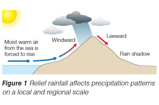
At a regional level, topography significantly influences precipitation patterns. Coastal areas of continents can be particularly wet due to the interaction between moist air from the sea and mountainous terrain.
Relief rainfall (also called orographic rainfall) occurs when warm, moist air from the sea is forced to rise over mountains or hills. As the air ascends the windward side (the side facing the wind), it cools and condenses, producing precipitation. By the time the air descends the leeward side (the side sheltered from the wind), it has lost most of its moisture, creating a dry rain shadow area.
Other factors that influence precipitation patterns include:
- Altitude: Higher areas tend to be cooler and often receive more precipitation
- Distance from the sea: Coastal areas typically receive more precipitation than inland areas
- Ocean currents: Warm currents increase evaporation and precipitation, while cold currents reduce it
Why are some areas wet and others dry?
Understanding the wettest and driest places on Earth helps us see how different factors combine to create extreme precipitation patterns.
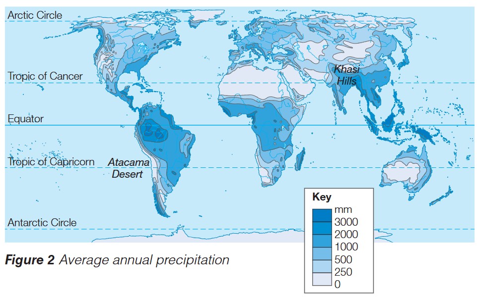
Case Study: Khasi Hills, Northern India (Wettest Place)
The Khasi Hills in northern India hold the record as the wettest place on Earth, receiving approximately 9,300 mm of rainfall in July 1861. This exceptional rainfall results from a combination of factors:
Location and topography: The hills are positioned in the path of moisture-laden winds from the Bay of Bengal. Wind blows over the flat land of Bangladesh and is suddenly forced to rise when it meets the steep slopes of the Khasi Hills.
Forced ascent: As the air is forced upward rapidly, it cools quickly, causing intense relief rainfall. The dramatic elevation change creates one of the most extreme examples of orographic precipitation in the world.
Monsoon influence: During the monsoon season, this effect is amplified, leading to torrential rainfall over a sustained period.
Case Study: Atacama Desert, South America (Driest Hot Desert)
In stark contrast, the Atacama Desert in South America is the driest hot desert on Earth, with an average annual rainfall of just 15 mm. Several factors contribute to this extreme aridity:
Location: The desert lies in the rain shadow of the Andes mountains. Moist air from the east loses its moisture as it rises over the mountains, leaving the western side exceptionally dry.
Cold ocean current: The desert is adjacent to a cold ocean current (the Humboldt Current). Cold currents cool the air above them, reducing its capacity to hold moisture. This means there is very little moist, warm air available to form clouds and produce precipitation.
High pressure: The region is dominated by a persistent high-pressure system, which causes descending air that warms and prevents cloud formation.
Case Study: Antarctica (Driest Cold Desert)
Antarctica represents a different type of extreme - the driest cold desert on Earth. Despite being covered in ice, it receives very little precipitation:
Extremely cold temperatures: The air in Antarctica is so cold that it can hold very little water vapour. Cold air has a much lower capacity to hold moisture compared to warm air.
High pressure dominance: Antarctica is dominated by high-pressure systems with descending air, which further reduces the possibility of precipitation.
Ice formation: What little precipitation does fall is in the form of ice crystals rather than rain, and this accumulates over thousands of years rather than falling as regular precipitation.
Understanding precipitation patterns
When examining precipitation patterns globally, several key observations emerge:
Global Precipitation Patterns by Region
Equatorial regions receive high precipitation due to intense insolation causing strong convectional rainfall. The warm, rising air creates persistent low-pressure zones.
Subtropical regions (around 30° north and south) tend to be dry, as these are zones of descending air in the global circulation system, creating high-pressure belts and desert conditions.
Mid-latitude regions experience variable precipitation influenced by frontal systems, where polar and tropical air masses meet.
Polar regions receive minimal precipitation due to extremely cold air that cannot hold much moisture, despite being ice-covered.
Multiple Factors Create Extreme Conditions
Extreme precipitation patterns rarely result from a single factor. The wettest and driest places on Earth demonstrate how multiple factors combine:
- The Khasi Hills combine relief rainfall with monsoon systems
- The Atacama Desert experiences rain shadow effects AND cold ocean currents AND high pressure
- Antarctica's extreme dryness results from cold temperatures AND high pressure systems
When explaining extreme precipitation, always consider how different factors work together to intensify conditions.
Exam guidance
Answering Precipitation Questions in Exams
- Describe questions require you to identify patterns and trends (e.g., "High precipitation occurs along the equator")
- Explain questions need you to provide reasons and mechanisms (e.g., "High precipitation occurs along the equator because intense insolation causes warm air to rise through convection, leading to condensation and rainfall")
- Use case studies with specific facts and figures to support your answers
- Link processes together: Show how multiple factors can combine to create extreme conditions
- Compare and contrast: When discussing wet and dry areas, explain why the conditions differ using geographical terminology
Example Comparison: When comparing the UK's precipitation (typically 500-1000mm annually) to the Khasi Hills (9,300mm in a single month), you should reference:
- The UK's mid-latitude position versus the Khasi Hills' tropical location
- The role of relief rainfall in both regions
- The intensity of the monsoon system affecting India
- The different scales of topography involved
Key Points to Remember
-
Precipitation is water falling from the atmosphere as rain, sleet, snow, or hail
-
Low pressure areas are wet (rising air cools, condenses, and produces precipitation), while high pressure areas are dry (sinking air warms and prevents cloud formation)
-
Three main types of rainfall: frontal (warm air rising over cold air), convectional (intense heating causing air to rise), and relief (air forced to rise over mountains)
-
Relief rainfall creates wet windward sides and dry leeward rain shadows on mountains
-
Extreme wet example: Khasi Hills, India (9,300mm in July 1861) - caused by forced ascent of moist air over mountains during monsoon season
-
Extreme dry examples: Atacama Desert (15mm annual rainfall) due to rain shadow and cold ocean current; Antarctica (driest cold desert) because air is too cold to hold moisture
-
Multiple factors often combine to create extreme precipitation patterns, including pressure systems, topography, latitude, ocean currents, and distance from the sea