Global Circulation System (OCR GCSE Geography B (Geography for Enquiring Minds)): Revision Notes
Global Circulation System
What is the global circulation system?
The global circulation system describes how air moves around Earth's atmosphere. This movement of air plays a crucial role in transferring heat from hot regions near the Equator to colder areas near the poles. Without this system, the temperature differences between the Equator and poles would be much more extreme.
The system works through ocean currents and winds working together to redistribute heat energy. This creates a balance in Earth's temperature and is the reason why different parts of the world experience different climates and weather patterns.
The global circulation system is essential for maintaining life on Earth. Without this heat redistribution mechanism, equatorial regions would be unbearably hot while polar regions would be even more frozen, making much of the planet uninhabitable.
How the system is driven
The global circulation system operates because of two fundamental processes involving air pressure:
The Temperature-Pressure Relationship
Warm air and low pressure: When air is heated (particularly at the Equator), it becomes less dense and rises into the atmosphere. As the air rises, it creates an area of low pressure at the surface. Low pressure areas are associated with clouds forming and high levels of precipitation.
Cool air and high pressure: When air cools down (particularly at higher latitudes), it becomes denser and sinks towards the Earth's surface. This descending air creates areas of high pressure. High pressure zones typically experience dry conditions with little rainfall and clearer skies.
The three atmospheric cells
The global circulation system is organized into three major circulation cells in each hemisphere: the Hadley cell, the Ferrel cell, and the Polar cell. These cells form distinct belts of high and low pressure around the planet.
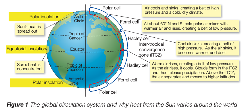
Hadley cells operate between the Equator and approximately 30° latitude (north and south). At the Equator, intense heating from the Sun causes air to rise, creating the Inter-Tropical Convergence Zone (ITCZ) - a belt of low pressure. As this warm air rises, it cools and moves towards 30° latitude. Here it sinks back down, creating a belt of high pressure. This descending air becomes warmer and drier as it sinks.
The ITCZ is sometimes called the "doldrums" by sailors because the converging trade winds and rising air create calm conditions with little horizontal wind, making it difficult for sailing ships to navigate.
Ferrel cells are found between approximately 30° and 60° latitude in both hemispheres. At around 60° north and south, cold polar air meets warmer air from lower latitudes. The warmer air is forced to rise, creating a belt of low pressure. The air then moves back towards 30° latitude where it sinks.
Polar cells operate between 60° latitude and the poles. Cold, dense air at the poles sinks, creating high pressure. This air then moves towards 60° latitude where it meets warmer air and is forced to rise. The high pressure at the poles results in a cold, dry climate.
Climate zones around the world
The global circulation system controls both temperature and precipitation patterns, which creates distinctive climate zones across the planet. The position of high and low pressure belts determines what type of climate an area experiences.
Hot and wet climates develop where air rises at the Equator. The rising air in the ITCZ cools as it gains altitude, causing water vapor to condense and form clouds. This leads to high rainfall in equatorial regions, creating tropical climates.
Hot and dry climates form where air sinks at approximately 30° latitude north and south (the subtropics). As the air descends, it warms up and any moisture evaporates. This creates the world's major hot desert regions, such as the Sahara Desert in Africa and deserts in Australia.
Unsettled weather occurs around 60° north and south where cool polar air meets warmer air from lower latitudes. The warm air is forced to rise, creating low pressure and frequent precipitation. This produces the mild, wet climates found in countries like the UK.
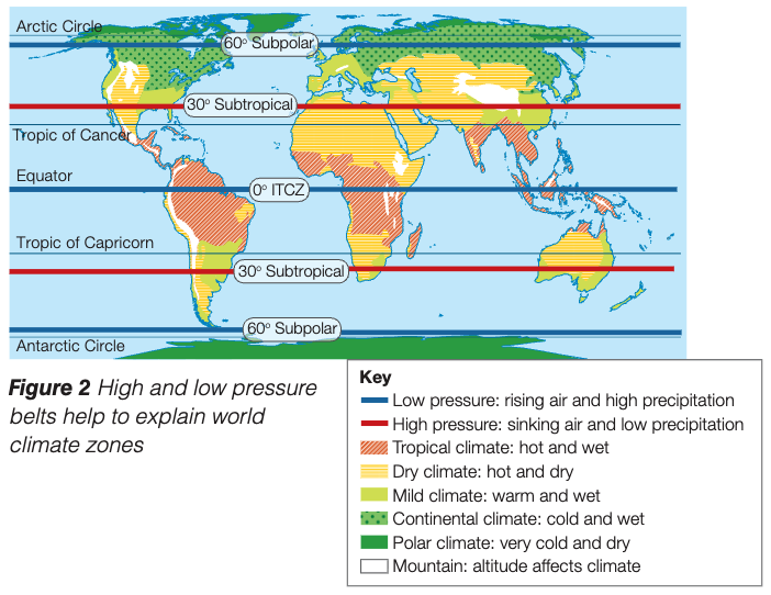
Understanding the Diagram
The diagram above shows how these pressure belts align with different climate zones:
- Blue lines indicate low pressure zones with rising air and high precipitation
- Red lines show high pressure zones with sinking air and low precipitation
The climate zones include tropical (hot and wet), dry (hot and dry), mild (warm and wet), continental (cold and wet), and polar (very cold and dry) climates. Mountain regions can also experience their own distinctive climates due to altitude effects.
Remember!
Key Points to Remember:
- The global circulation system is the movement of air around the world, transferring heat from the Equator to the poles
- Warm air rises and creates low pressure, bringing clouds and rain
- Cool air sinks and creates high pressure, bringing dry, settled conditions
- Three circulation cells (Hadley, Ferrel, and Polar) create belts of high and low pressure at different latitudes
- These pressure belts control global climate zones: low pressure at the Equator creates hot, wet tropical climates while high pressure at 30° latitude creates hot, dry desert climates