Aerial Photographs and Orthophoto Maps (Grade 10 NSC Matric Geography): Revision Notes
Oblique and Vertical Aerial Photographs
Aerial photography is a powerful geographical tool that allows us to see the world from above. Unlike ordinary photographs taken from ground level, aerial photographs are captured from aircraft flying at various altitudes. These images provide unique perspectives that are essential for mapping, planning, and understanding our environment.
What are aerial photographs?
An aerial photograph is simply an image taken from an aircraft, such as an aeroplane or helicopter. This differs from a horizontal photograph (also called a terrestrial photograph), which is taken from the earth's surface at ground level.
The key difference lies in the camera's position: terrestrial photographs are taken from ground level, while aerial photographs are captured from aircraft at various altitudes above the earth's surface.
There are two main types of aerial photographs, each offering different perspectives and uses:
Types of aerial photographs
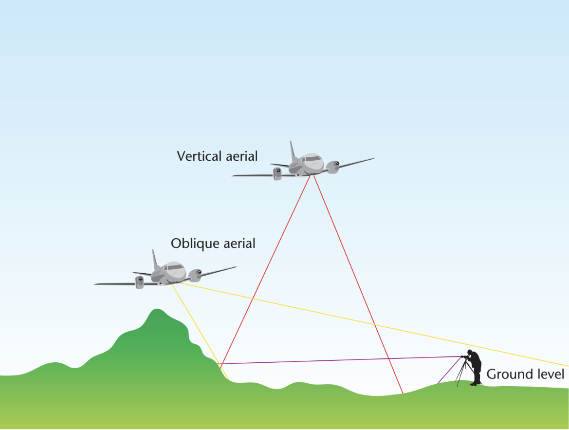
Vertical aerial photographs
A vertical aerial photograph is taken when the camera points straight down, perpendicular to the earth's surface. This creates a "bird's-eye view" or "top-down view" of the landscape below.
Key characteristics:
- Camera positioned directly downward at 90° to the ground
- Provides a view looking straight down at the earth
- Shows features as they would appear on a map
- Scale remains uniform across the entire photograph
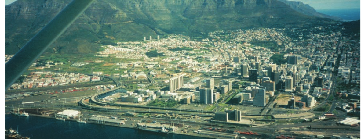
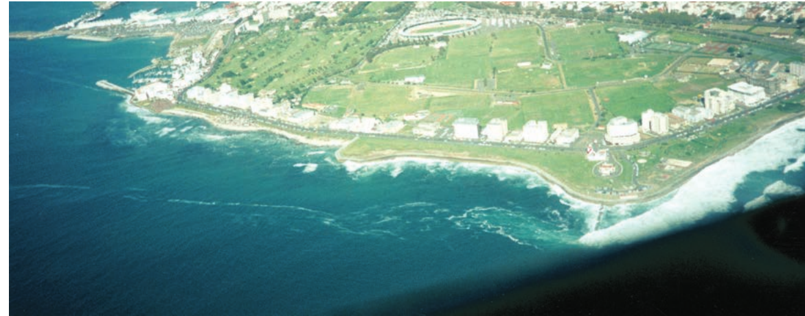
Oblique aerial photographs
An oblique aerial photograph is taken when the camera is tilted at an angle away from the vertical position. This creates a side view that shows both the ground and the horizon.
There are two types of oblique photographs:
High-angle oblique:
- Camera tilted at approximately 60° from vertical
- The horizon line is visible in the photograph
- Shows a wider area but with more distortion
Low-angle oblique:
- Camera tilted at approximately 30° from vertical
- The horizon line is not visible in the photograph
- Shows less area but with better detail of foreground features
Comparing oblique and vertical aerial photographs
| Oblique Aerial Photographs | Vertical Aerial Photographs |
|---|---|
| Camera position: Tilted away from vertical | Camera position: Perpendicular to earth's surface |
| View type: Side view with familiar perspective | View type: Top-down bird's-eye view |
| Scale: Distorted - objects appear larger when closer to camera | Scale: Uniform across entire photograph |
| Horizon: Visible in high-angle, not visible in low-angle | Horizon: Not visible |
Advantages of oblique photographs
Benefits of the oblique perspective:
Oblique photographs offer several advantages that make them particularly useful for initial reconnaissance and general landscape assessment.
- Provide a "regular" or familiar view that resembles how we normally see landscapes
- Easy to identify and recognise geographical features
- Simple to compare the relative heights of different objects
- Natural perspective makes interpretation easier for beginners
Disadvantages of oblique photographs
Critical limitations to consider:
The main drawback of oblique photographs is their scale distortion, which makes them unsuitable for precise measurements or detailed mapping work.
- Features in the foreground can hide or obscure features in the background
- Scale becomes distorted across the image - closer objects appear much larger
- Accurate measurements and calculations cannot be performed reliably
- Limited usefulness for precise mapping work
Advantages of vertical photographs
- Maintain uniform scale throughout the image, making measurements possible
- Objects and features do not obscure each other
- Transport networks like roads and railways are clearly visible
- Perfect for updating existing maps with new information
- Can create stereo pairs that allow three-dimensional viewing
- Shadows help determine the height of buildings and the time the photograph was taken
Disadvantages of vertical photographs
Interpretation challenges:
While vertical photographs are excellent for mapping, they require specialized training to interpret effectively due to their unfamiliar perspective.
- Unfamiliar bird's-eye perspective can be difficult to interpret initially
- When photographed from high altitude, excessive detail can make specific features hard to identify
- Shadows may hide important details in certain areas
- Requires training to read and interpret effectively
Uses and applications of aerial photographs
Aerial photographs serve many important purposes across different professions. The uniform scale of vertical photographs and the familiar perspective of oblique photographs make them valuable tools in various fields:
- Cartographers use them for creating and updating maps
- Military personnel rely on them for reconnaissance and strategic planning
- Farmers monitor land-use patterns and identify crop diseases
- Environmental planners count wildlife, track animal movements, and monitor deforestation and desertification
- Urban planners identify suitable locations for new settlements and infrastructure
- Geologists explore for minerals and locate potential mining sites
- Engineers plan road construction and dam-building projects
Professional versatility:
The wide range of applications demonstrates why aerial photography has become an indispensable tool across multiple industries, from agriculture to urban development.
How aerial photographs are taken
Taking aerial photographs requires careful planning and specialised equipment. A professional camera is mounted onto an aircraft, with the lens positioned either perpendicular to the ground (for vertical photos) or tilted at a specific angle (for oblique photos).
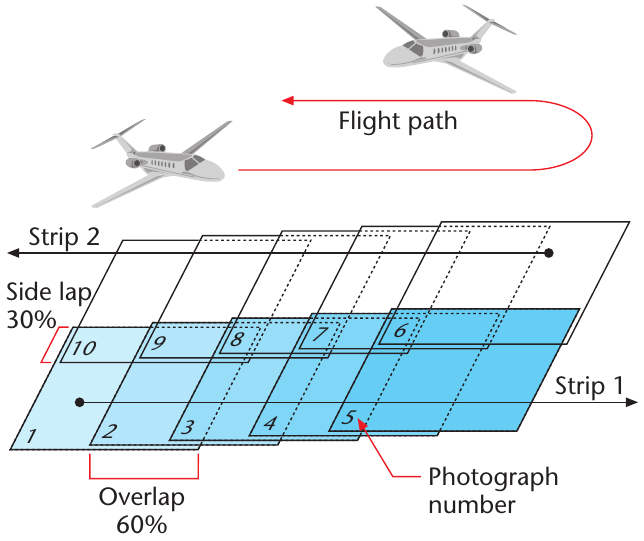
The survey process
The aircraft follows a systematic flight pattern over the area to be photographed:
Systematic coverage requirements:
The overlapping flight pattern ensures complete coverage of the survey area while providing the necessary image pairs for stereoscopic viewing.
- Flight strips: The plane flies in parallel strips, usually in an east-west direction
- Constant altitude: The aircraft maintains the same height throughout to prevent scale distortion
- Side overlap: Each flight strip overlaps the adjacent strip by 30%
- Forward overlap: Individual photographs overlap by 60% along each strip
- Timing: Photos are typically taken between 10 am and 2 pm when the sun is directly overhead to minimise shadows
- Weather conditions: Clear, fair weather is essential for high-quality images
Technical details
Essential metadata:
Every professional aerial photograph contains crucial technical information in its margins that helps users understand the image's specifications and limitations.
Important information appears in the margins of vertical aerial photographs, including:
- Date and time the photograph was taken
- Strip number and photograph number within that strip
- Job number for the survey project
- Height at which the aircraft was flying
- Tilt or angle of the camera in relation to the earth's surface
Stereoscopic viewing
A stereoscope is a special instrument that uses mirrors to create a three-dimensional view when looking at two overlapping vertical aerial photographs. When you view two adjacent photographs from the same flight strip through a stereoscope, your brain merges the two separate images into a single 3D image.
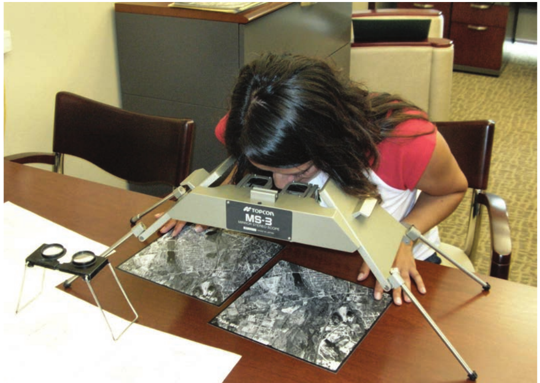
These paired photographs are called a stereo pair. Stereoscopes can range from simple, basic equipment to highly sophisticated instruments used by professional photo interpreters. This 3D viewing capability helps experts better understand terrain features, building heights, and landscape relationships.
How stereoscopic viewing works:
Step 1: Take two overlapping vertical aerial photographs from slightly different positions along a flight strip
Step 2: Place the photographs side by side in the stereoscope
Step 3: Look through the instrument's eyepieces - each eye sees one photograph
Step 4: Your brain combines the two images to create a single three-dimensional view
Key Points to Remember:
- Vertical aerial photographs provide uniform scale and are perfect for mapping, but require training to interpret effectively
- Oblique aerial photographs offer familiar perspectives that are easy to understand, but suffer from scale distortion
- Systematic flight patterns with 60% forward overlap and 30% side overlap ensure complete coverage of survey areas
- Stereoscopes transform paired photographs into three-dimensional images for enhanced interpretation
- Multiple professions rely on aerial photography for planning, monitoring, and decision-making in their respective fields