Map Skills (Grade 10 NSC Matric Geography): Revision Notes
Scale
What is scale?
Scale is a fundamental concept in geography that shows us how much smaller a map is compared to the real world. Think of scale as a way of shrinking the enormous world down to fit on a piece of paper whilst keeping everything in the correct proportions. When we use maps, we need to understand exactly how much smaller the map is than reality so we can work out real distances and areas.
Maps can show different amounts of detail depending on their scale. A map showing the whole of South Africa will have less detail than a map showing just your local area. This is because we have the same amount of space on paper, but we're trying to fit different amounts of the real world onto it.
Below you can see three maps drawn to three different scales.
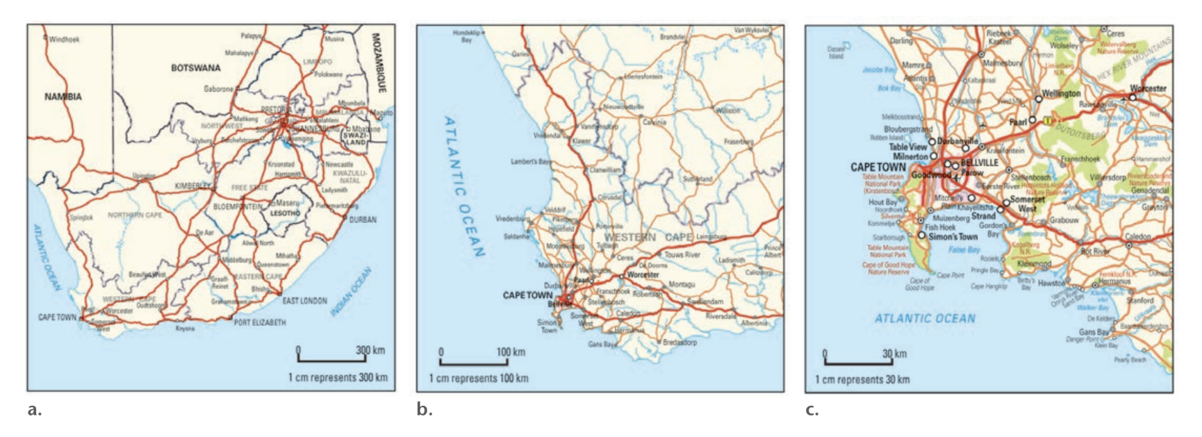
The scale determines how much land area appears on your map. This relationship is crucial for understanding what level of detail you can expect from any map you're using.
Maps covering large areas use a small scale, whilst maps showing small areas in great detail use a large scale.
Three ways of representing scale
Geographers use three main methods to show scale on maps: word scale, ratio scale, and line scale. Each method has its advantages and is useful in different situations.
Word scale
Word scale is the simplest way to describe how big or small a map is. It uses everyday language to explain the relationship between distances on the map and distances in the real world.
Word Scale Example: "One centimetre represents ten kilometres"
This tells us that every 1 cm you measure on the map equals 10 km in the real world.
The key word to remember is "represents" - we always say one unit on the map represents a certain distance on the ground. We never say it equals that distance, because the map is obviously much smaller than the real world. The word "represents" reminds us that we're looking at a scaled-down version of reality.
Word scales are particularly helpful for beginners because they're easy to understand and use everyday language that makes sense to most people.
Ratio scale
Ratio scale describes the relationship between map distance and ground distance using numbers. It compares one unit of measurement on the map with the same unit of measurement in the real world.
Ratio Scale Example: A ratio scale of 1:100,000 means that 1 centimetre on the map represents 100,000 centimetres on the ground.
The format looks like this: 1:50,000 (read as "one to fifty thousand")
This tells us that 1 unit of measurement on the map equals 50,000 of the same units on the ground.
It's crucial that both measurements use exactly the same units - you cannot mix different units in a ratio scale. If you measure in centimetres on the map, the ground distance must also be in centimetres.
One of the most common ratio scales you'll encounter is 1:50,000, which is the standard scale for topographic maps. This means that every millimetre on the map represents 50,000 millimetres (which equals 50 metres) on the ground.
You can also express ratio scale as a fraction, such as . This is called a representative fraction and means exactly the same thing as writing 1:100.
Line scale
Line scale shows the scale visually using a measured line with distance markings. If you look at a line scale, you can see exactly how long distances are on the map by measuring against the scale line.

Line scales have a major advantage: they remain accurate even if someone photocopies or enlarges the map. Unlike word scales or ratio scales, which become incorrect if the map size changes, line scales change proportionally with the map and stay accurate.
The line scale shows you immediately what real-world distance any measurement on the map represents. You can use a ruler to measure distances on the map, then compare your measurement to the line scale to find the actual ground distance.
Working with measurement units
Understanding the metric system is essential when working with map scales. Here are the key relationships you need to remember:
Metric System Relationships:
- 10 millimetres = 1 centimetre
- 100 centimetres = 1 metre
- 1,000 metres = 1 kilometre
When working with scales, it's often easier to think in terms of metres and kilometres rather than smaller units. For example, if you have a 1:50,000 scale map, you can work out that 1 centimetre on the map represents 500 metres on the ground (because 50,000 centimetres equals 500 metres).
Worked Example: Converting 1:50,000 Scale
Step 1: Start with the ratio 1 cm on map = 50,000 cm on ground
Step 2: Convert to more useful units 50,000 cm ÷ 100 = 500 metres
Step 3: Final result 1 centimetre on the map represents 500 metres on the ground
Understanding scale relationships
There's an important relationship between scale numbers and the area they show that often confuses students:
The Scale Relationship Rule:
- Small scale numbers (like 1:1,000,000) show large areas with less detail
- Large scale numbers (like 1:10,000) show small areas with more detail
This might seem backwards at first, but think about it mathematically!
Think about it mathematically. In the fraction , you're dividing by a very large number, which gives you a very small result. This small result means the map shows things much smaller than reality, so you can fit a large area onto the page.
Conversely, is a much larger fraction, meaning things on the map are closer to their real size, so you can only fit a small area with lots of detail.
A helpful way to remember this: imagine you're looking at the world from different heights. The higher you go (smaller scale), the more area you can see, but with less detail. The closer you get (larger scale), the less area you see, but with much more detail.
Remember!
Key Points to Remember:
- Scale shows how much smaller a map is than the real world - it's essential for understanding distances and areas on any map
- Word scale uses everyday language like "1 centimetre represents 10 kilometres" and is the easiest method for beginners to understand
- Ratio scale uses numbers like 1:50,000, where both measurements must use the same units (commonly used on topographic maps)
- Line scale shows distance visually and stays accurate even if the map is copied or resized
- Remember the scale relationship: small scale numbers = large areas shown, large scale numbers = small areas with more detail