Direction, Bearing, and Magnetic Bearing (Grade 10 NSC Matric Geography): Revision Notes
Direction, Bearing, and Magnetic Bearing
Understanding direction and compass points
Direction helps us describe where one place is located in relation to another place. When we look at maps, we use a system based on compass points to give clear directions.
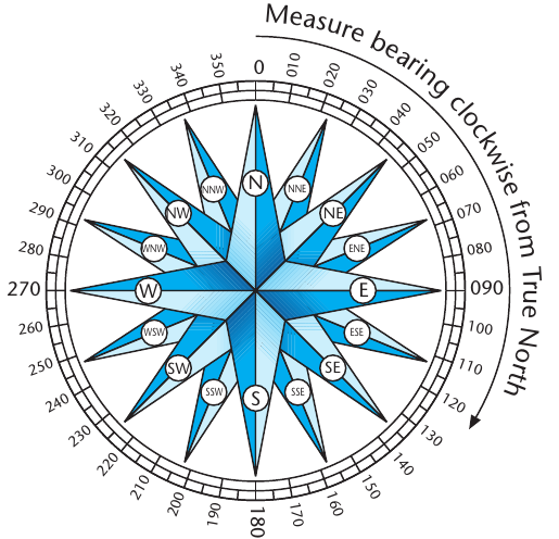
The traditional compass system uses 16 different directional points. These include the four main directions (North, South, East, West) and twelve additional points like Northeast, Northwest, Southeast, and Southwest. This system provides a general way to describe direction, but it's not always precise enough for detailed navigation work.
An important rule to remember when reading maps is that north is typically located at the top of the map, unless an arrow indicates otherwise. This standard orientation helps ensure everyone reads maps consistently.
What is bearing?
Bearing provides a much more accurate way to indicate direction than using compass points alone. Instead of just 16 compass directions, the bearing system uses a full 360-degree circle to pinpoint exact directions.
Here's how bearing works:
- We measure angles in degrees (°) from to
- All measurements start from north ()
- We always measure clockwise around the circle
- East is at , South is at , and West is at
This system gives us much greater precision. Instead of saying "northeast," we can specify exactly "" or "" to show the precise direction.
Measuring bearing step by step
To measure bearing between two places on a map, follow these steps:
- Connect the points: Join the two locations with a straight pencil line on your map
- Draw a north-south line: Draw a line running north-south through your starting point (the 'from' location)
- Position your protractor: Place the centre of your protractor on your starting point, making sure the north-south line passes through on your protractor
- Measure clockwise: Measure the angle clockwise from north () to your destination line
- Read the bearing: The measurement where your line crosses the protractor scale gives you the true bearing
This measurement gives you what we call the true bearing - the angle measured from True North.
True bearing explained
True bearing uses True North as its reference point. True North represents the geographical North Pole - the exact point where all the longitude lines meet on Earth. When we measure bearing on a map, we use True North as our starting point.
True North remains constant and doesn't change position. This makes it reliable for map work and navigation calculations. Maps are designed with True North in mind, which is why the bearing measurements you take from maps are called "true bearings."
Magnetic bearing and magnetic declination
In real-world navigation, however, things become more complicated. When explorers and navigators use an actual compass in the field, the compass needle doesn't point to True North. Instead, it points to magnetic north.
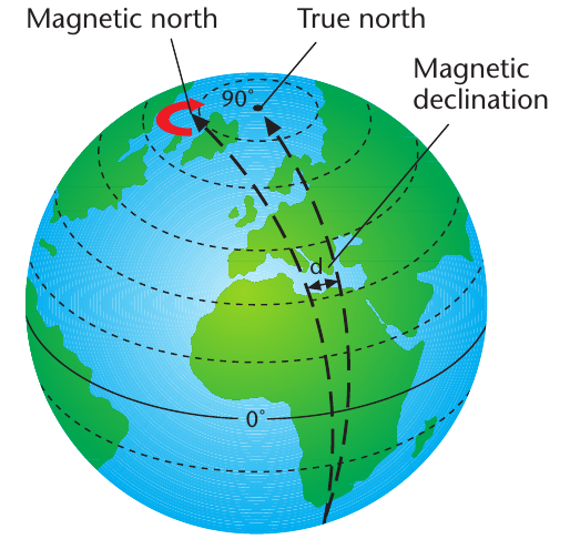
Magnetic north refers to the northern magnetic pole of our planet. This magnetic pole is located west of True North and constantly moves slowly across the Arctic region. The angle between True North and magnetic north is called magnetic declination.
Understanding magnetic declination is crucial because:
- Compass readings in the field will be based on magnetic north
- Maps show True North orientation
- We need to convert between the two systems for accurate navigation
Magnetic declination varies depending on your location on Earth and changes gradually over time. Topographic maps usually indicate the magnetic declination for that area and the year it was measured.
Calculating magnetic bearing
Sometimes you need to convert between true bearing and magnetic bearing. This becomes necessary when you're working with both map measurements (true bearing) and compass readings (magnetic bearing).
The relationship is:
Here's how to calculate current magnetic declination when you know historical data:
- Start with historical declination: Find the magnetic declination for a past year
- Calculate time difference: Work out how many years have passed since that measurement
- Apply annual change: Multiply the yearly change rate by the number of years
- Determine current declination: Add or subtract the total change from the historical declination
Important rules for adding/subtracting:
- If magnetic declination is west of True North AND the annual change is also westward: ADD the change
- If magnetic declination is west of True North BUT the annual change is eastward: SUBTRACT the change
Worked Example: Calculating Magnetic Bearing
Given data:
- Historical declination (2001):
- Annual change: (westward)
- Years passed (2001 to 2012): 11 years
- True bearing:
Step 1: Calculate total change Total change =
Step 2: Find current declination Current declination =
Step 3: Calculate magnetic bearing Magnetic bearing =
Remember!
Key Points to Remember:
-
Direction uses 16 compass points to show the relative position of places, while bearing uses 360 degrees for precise measurements
-
Always measure bearing clockwise from north - this is the universal standard for navigation
-
True bearing uses True North (geographical North Pole) as the reference point, which is what you'll measure on maps
-
Magnetic bearing uses magnetic north as the reference point, which is where compass needles actually point in the field
-
Magnetic declination is the angle between True North and magnetic north - you need this to convert between map bearings and compass bearings