Reading and Interpreting Maps (Grade 10 NSC Matric Geography): Revision Notes
Reading and Interpreting Maps
Understanding how to read and interpret maps is a fundamental skill in geography that helps us locate places precisely anywhere in the world. Maps use special systems called grids to help us describe exact positions, much like using an address to find a house.
What are co-ordinates?
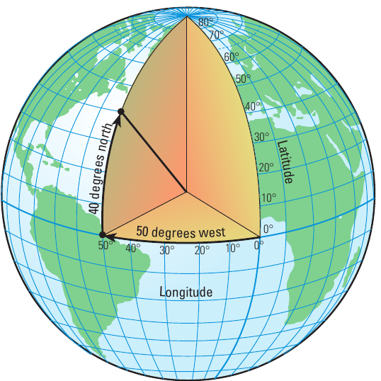
Co-ordinates are the exact position where lines of latitude and longitude meet on a map. Think of them as the "address" of any location on Earth. Just like your home has a street address, every place on our planet has co-ordinates that tell us exactly where it is.
When we look at maps in an atlas, we notice grid lines marked across them. These lines help us describe positions using latitude and longitude measurements.
Worked Example: Finding Durban's Location
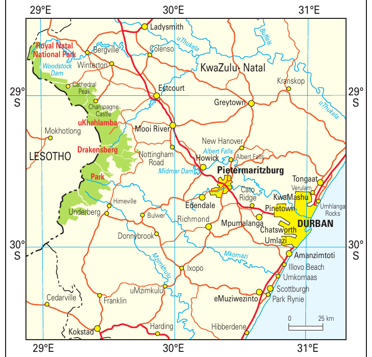
The city of Durban in South Africa is located at 29°50'S and 31°01'E. These numbers are the co-ordinates that pinpoint Durban's exact location:
- 29°50'S means 29 degrees and 50 minutes south of the equator
- 31°01'E means 31 degrees and 1 minute east of the Prime Meridian
Using co-ordinates is much more accurate than simply saying "Durban is on the east coast of South Africa." Co-ordinates give us precision, which is essential for navigation, weather reporting, and many other geographical applications.
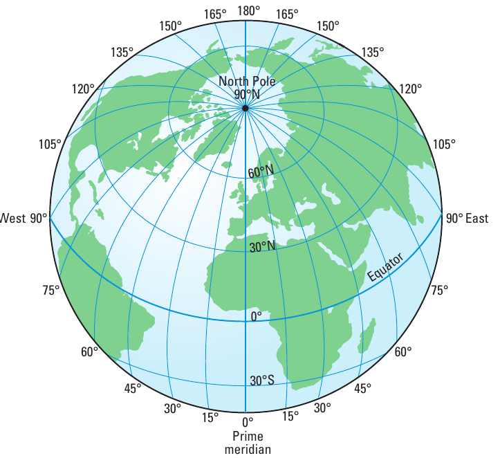
Understanding latitude - the horizontal lines
Lines of latitude are imaginary horizontal lines that run from east to west across maps and globes. These parallel lines help us measure distances north and south of the equator.
The most important line of latitude is the equator, which sits at 0° latitude. The equator divides Earth into two equal halves called hemispheres - the Northern Hemisphere (above the equator) and the Southern Hemisphere (below the equator). South Africa is located in the Southern Hemisphere.
From the equator, we can measure distances in both directions:
- 90 degrees north to reach the North Pole
- 90 degrees south to reach the South Pole
The symbol for degrees is °, so we write latitude measurements like 30°N (30 degrees north) or 45°S (45 degrees south).
All lines of latitude run parallel to the equator, which is why they're sometimes called "parallels."
Understanding longitude - the vertical lines
Lines of longitude are imaginary vertical lines that run from north to south, connecting the North Pole to the South Pole. Unlike latitude lines, longitude lines are not parallel to each other - they meet at the poles.
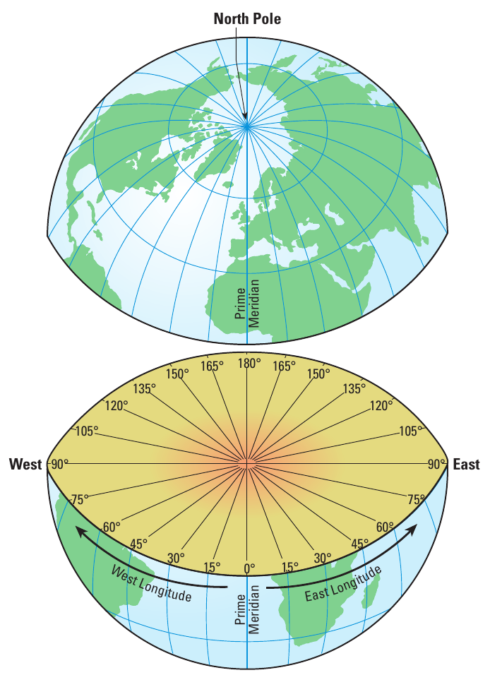
The most important line of longitude is the Prime Meridian (also called the Greenwich Meridian), which sits at 0° longitude. This line runs through Greenwich, England, and is the starting point for measuring all other longitude lines.
From the Prime Meridian, we can measure distances in both directions:
- 180 degrees east towards Asia and the Pacific Ocean
- 180 degrees west towards the Americas
Lines of longitude help us calculate world time zones and determine whether a location is in the Eastern or Western Hemisphere.
How the grid system works together
When lines of latitude and longitude intersect (cross each other), they form a grid pattern across the Earth's surface. Each intersection point has unique co-ordinates that identify that exact location.
To write co-ordinates correctly, we always give:
- Latitude first (how far north or south of the equator)
- Longitude second (how far east or west of the Prime Meridian)
Understanding Co-ordinate Format
Durban's co-ordinates are 29°50'S and 31°01'E, which means:
- 29 degrees and 50 minutes south of the equator
- 31 degrees and 1 minute east of the Prime Meridian
Practical application: Locating places
Let's look at how this system works in practice using the KwaZulu-Natal region of South Africa. This area includes major cities like Durban, Pietermaritzburg, and Ladysmith.
When geographers want to describe Durban's location precisely, they use its co-ordinates: 29°50'S and 31°01'E. This tells us that Durban is located in the Southern Hemisphere (south of the equator) and in the Eastern Hemisphere (east of the Prime Meridian).
The grid system is particularly useful for:
- Navigation: Ships and aeroplanes use co-ordinates for precise routing
- Emergency services: Rescue teams can locate people in distress
- Weather reporting: Meteorologists track weather patterns using grid references
- Scientific research: Researchers can share exact locations of their studies
Alphanumeric grid referencing
Some maps use an alphanumeric grid referencing system instead of latitude and longitude. This system uses letters and numbers to create squares on a map grid. For example, a location might be in square E5, where 'E' represents a column and '5' represents a row.
This system is often used for:
- Local area maps
- Street directories
- Hiking and camping maps
- Urban planning documents
While simpler than latitude and longitude, alphanumeric systems only work for the specific map they're designed for, unlike co-ordinates which work globally.
Tips for reading map co-ordinates
Here are some helpful strategies for working with co-ordinates:
Key Strategies for Working with Co-ordinates:
- Remember the order: Always latitude first, then longitude
- Check the hemispheres: Northern/Southern for latitude, Eastern/Western for longitude
- Use reference points: The equator (0° latitude) and Prime Meridian (0° longitude) are your starting points
- Practice with familiar places: Start by finding co-ordinates for cities you know well
- Pay attention to symbols: The degree symbol (°) is essential in co-ordinate notation
Remember!
Key Points to Remember:
- Co-ordinates show exact positions where latitude and longitude lines intersect on maps
- Latitude lines run horizontally (east to west) and measure distance from the equator (0°)
- Longitude lines run vertically (north to south) and measure distance from the Prime Meridian (0°)
- The grid system is universal - it works the same way on any map of the world
- Practice makes perfect - the more you work with co-ordinates, the easier map reading becomes