Global Air Circulation (Grade 11 NSC Matric Geography): Revision Notes
Winds Related to Regional and Local Air Movements
Understanding how winds behave on regional and local scales helps us explain many weather patterns we experience. While global wind patterns create the broad framework of atmospheric circulation, smaller-scale pressure differences also create distinctive wind systems. These regional and local winds often have significant impacts on climate, weather, and human activities in specific areas.
Monsoons
Monsoons represent one of the most important regional wind systems affecting billions of people worldwide. These winds demonstrate how seasonal changes in temperature and pressure can completely reverse wind directions across vast areas.
What are monsoons?
A monsoon is a wind system that completely changes direction between summer and winter seasons. This directional switch happens because of dramatic seasonal changes in temperature, which create corresponding changes in atmospheric pressure.
The most famous example occurs across Asia, where the monsoon affects weather patterns from India to East Asia. This system demonstrates the powerful connection between temperature differences and atmospheric circulation.
Winter monsoon patterns
During winter months, the Asian continent becomes extremely cold while the surrounding oceans remain relatively warm. This temperature difference creates a powerful high-pressure system over the cold landmass.
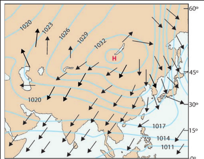
The winter pattern shows cold, dry air flowing outward from the high-pressure center over the continent. Because the land becomes much colder than the ocean, pressure builds up over the interior regions. This high-pressure system forces dry air to flow toward the lower-pressure areas over the warmer oceans.
Winter Monsoon Effect: High pressure over cold continents pushes dry air toward warmer oceans, resulting in generally dry, clear weather across much of the continent during winter months.
Summer monsoon patterns
The situation completely reverses during summer when intense heating of the large Asian landmass creates very different pressure conditions.
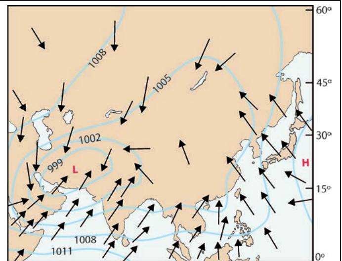
In summer, the continent heats up much more than the surrounding oceans, creating low pressure over the land. Meanwhile, the oceans remain relatively cool and maintain higher pressure. This pressure difference draws warm, moist air from the oceans onto the continent.
Summer Monsoon Process:
Step 1: Continental heating creates low pressure over land
Step 2: Ocean areas maintain higher pressure due to slower heating
Step 3: Pressure difference draws moist air inland
Step 4: Incoming moist air rises, cools, and condenses into heavy rainfall
How monsoons form
The monsoon system works because land and water heat up and cool down at very different rates. During summer, continental areas become much hotter than ocean areas, causing air to rise and creating low pressure. This low pressure acts like a giant vacuum, drawing moist air inland from the high-pressure areas over the cooler oceans.
In winter, the opposite occurs. The continent cools much more rapidly than the ocean, creating high pressure over the cold land. This high pressure pushes dry, cold air outward toward the relatively warmer, low-pressure areas over the oceans.
The key to understanding monsoons lies in recognizing that land masses and ocean bodies respond very differently to seasonal temperature changes, creating the pressure differences that drive these massive wind reversals.
Föhn winds
Föhn winds represent an important type of local wind system created when air masses encounter mountain barriers. These winds demonstrate how topography can dramatically alter local weather conditions.
Understanding föhn winds
A föhn is a hot, dry wind that flows down the leeward (downwind) side of mountains. Originally named after similar winds in the European Alps, the term now applies to this type of wind system wherever it occurs.
Different regions have their own local names for these winds, such as the Chinook winds in the Rocky Mountains of North America. These winds can cause dramatic local weather changes and have significant impacts on agriculture and fire risk.
The föhn formation process
The creation of föhn winds involves a fascinating sequence of atmospheric processes as air moves over mountain ranges.
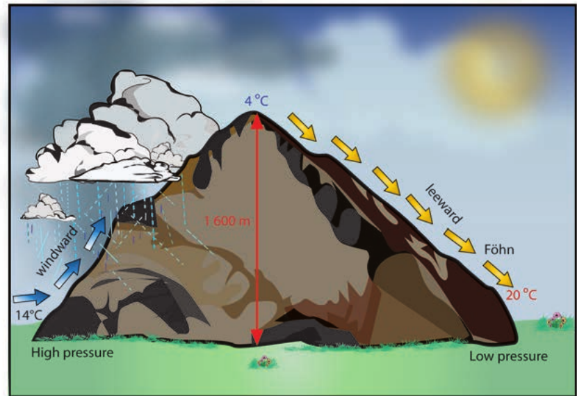
When moist air encounters a mountain range, it is forced to rise up the windward side. As this air rises, it cools and expands, following the dry adiabatic lapse rate of approximately for every meters of altitude gained. Eventually, the rising air reaches its condensation level, where water vapor begins to form clouds and precipitation.
Critical Process Change: Once condensation begins, the air continues cooling but now at a slower rate called the wet adiabatic lapse rate (approximately per meters). This happens because the condensation process releases latent heat, which partly offsets the cooling due to expansion.
After crossing the mountain peak, the air begins descending the leeward side. However, most of its moisture has already been lost as precipitation on the windward side. The now-dry air descends and warms at the dry adiabatic lapse rate of per meters.
Föhn Formation Steps:
Step 1: Moist air rises up windward side, cooling at Step 2: Air reaches condensation level, precipitation occurs Step 3: Air continues rising, cooling at (wet rate) Step 4: Dry air crosses peak and descends leeward side Step 5: Descending air warms at , becoming hot and dry
Temperature effects of föhn winds
The föhn process creates dramatic temperature differences between the windward and leeward sides of mountains. Air that started at perhaps at the base of the windward side might reach or higher at the corresponding elevation on the leeward side.
This temperature increase can cause rapid snow melting, create fire hazards, and produce sudden weather changes that can be quite dramatic. The warming effect occurs because the air loses moisture (and therefore mass) during its passage over the mountain, but gains the same amount of heat energy during descent that it lost during ascent.
Key Insight: With less moisture to absorb this heat energy, the remaining dry air becomes significantly warmer than it was originally. This is why föhn winds are characteristically both hot and dry.
Key Points to Remember:
-
Monsoons are seasonal wind reversals caused by temperature differences between land and ocean that change dramatically between summer and winter
-
Winter monsoons bring dry conditions as high pressure over cold continents pushes dry air toward warmer oceans
-
Summer monsoons bring wet conditions as low pressure over hot continents draws moist air inland from cooler oceans
-
Föhn winds are hot and dry because they lose moisture while crossing mountains but regain heat energy while descending
-
Mountain barriers create local weather differences with wet conditions on windward sides and dry conditions on leeward sides
-
Adiabatic rates are crucial: Dry rate = , Wet rate =