Maps That Help You Find Your Way (Grade 11 NSC Matric Mathematical Literacy): Revision Notes
Maps That Help You Find Your Way
Introduction to map navigation skills
Map reading is an essential skill that helps you navigate and plan journeys effectively. Different types of maps provide varying levels of detail depending on your needs, from planning long-distance trips to finding specific addresses within a neighbourhood.
Maps are designed with a specific purpose in mind. Understanding which type of map to use in different situations is crucial for effective navigation and journey planning.
The key skills you need to master include:
- Making sense of information shown on various maps
- Following and describing directions accurately
- Using grid reference systems to locate specific places
- Using scales (both number and bar scales) to estimate distances
- Planning trips, including calculating travelling times, costs and speeds
Types of maps and their progression
Maps follow a deliberate progression from showing large areas with limited detail to showing small areas with extensive detail. This progression reflects how people typically use maps when travelling - starting with broad route planning and then focusing on specific sections as needed.
The four main types of maps
1. National road map
- Shows very large area of land with limited detail
- Displays major routes between cities and towns across the country
2. Strip-chart
- Shows smaller area of land (specific road sections between towns)
- Includes much more detail about the route than visible on national maps
3. Street map
- Shows much smaller area of land with significantly more detail
- Focuses on streets, buildings and facilities within cities or towns
4. Housing complex map
- Shows very small area with detailed information not visible on other maps
- Focuses on individual houses and internal pathways within residential areas
The "Big to Small" Progression
Think of maps as following a zoom-in pattern: National maps give you the "big picture" view of long-distance routes, while housing complex maps provide the "zoomed-in" view needed to find a specific address. Each type serves a different navigation purpose.
Map skills for different map types
National road maps
National road maps help you plan long-distance journeys across the country. The essential skills include:
-
Route selection: Choosing the most appropriate roads to travel between destinations
-
Distance calculation: Determining total distances using the map scale
-
Time estimation: Calculating travelling times based on average speeds (typically 100 km/h for highway travel)
-
Cost planning: Estimating fuel costs and identifying stopping points for refuelling
-
Distance tables: Using provided tables to find direct distances between major cities

Distance Tables Warning
Distance tables only provide guidelines - actual travel distances may vary depending on the specific route chosen. Always add extra time and distance for unexpected detours or route changes.
Strip-charts
Strip-charts provide detailed information about specific route sections. Key skills include:
- Accurate distance measurement: Using distance markers shown in chart margins and on roads
- Detailed route planning: Identifying stopping points for fuel, accommodation or breaks
- Cost and time estimation: More precise calculations for specific route sections
- Landmark identification: Using towns and points of interest along the route
Example: Using distance markers to find the distance between Kimberley and Bloemfontein, or between Swinburne and Paul Roux.
Street maps and housing complex maps
These maps require more detailed navigation skills:
Street maps help you navigate within cities:
-
Symbol identification: Recognising symbols for schools, hospitals and other facilities
-
Direction following: Using street names and directional indicators (left, right, straight)
-
Grid references: Using coordinate systems with street indexes to locate specific addresses
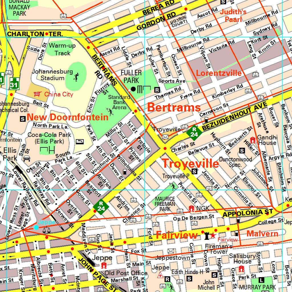
Housing complex maps help you navigate within residential areas:
- Landmark navigation: Using directional indicators and local landmarks
- Precise directions: Following detailed instructions to reach specific houses
- Small-scale orientation: Working with limited geographical area but high detail
Understanding scales
Scale shows the relationship between distances on a map and actual distances in the real world. All maps require you to estimate distances using scales when distance tables or markers aren't provided.
Key Scale Concept
You can only estimate distances using scales, not determine them with complete accuracy. Many factors affect accuracy, including measurement precision and route variations.
Two types of scale calculations
Calculation type 1: Measure distance on map → Calculate actual distance
- Measure the distance on the map using a ruler
- Multiply by the scale factor to find real-world distance
Calculation type 2: Know actual distance → Calculate map distance
- Start with known real-world distance
- Divide by the scale factor to find how long to draw it on the map
Number scales vs bar scales
Number scales
Number scales are expressed as ratios like 1:50 000.
Scale Definition
A scale of 1:50 000 means the actual distance is 50 000 times bigger than the measurement on the map. This is a fundamental concept that applies to all number scale calculations.
Key characteristics:
- Shows specific relationship between map and reality
- Easy to use for calculations
- Becomes inaccurate if the map is resized (enlarged or reduced)
Worked example - Number scale calculation type 1
Worked Example: Converting Map Distance to Actual Distance
Question: A measurement of 13.7 cm is made on a map with scale 1:50 000. What is the actual distance in kilometres?
Solution:
- Scale: 1:50 000 means actual distance = map distance × 50 000
- Actual distance = 13.7 cm × 50 000 = 685 000 cm
- Convert to metres: 685 000 cm = 6 850 m
- Convert to kilometres: 6 850 m = 6.85 km
Answer: 6.85 km
Worked example - Number scale calculation type 2
Worked Example: Converting Actual Distance to Map Distance
Question: The distance between two towns is 12 km. On a map with scale 1:50 000, how long will this distance measure?
Solution:
- Scale: 1:50 000 means map distance = actual distance ÷ 50 000
- Convert actual distance to cm: 12 km = 12 000 m = 1 200 000 cm
- Map distance = 1 200 000 cm ÷ 50 000 = 24 cm
Answer: 24 cm
Bar scales
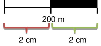
Bar scales show the relationship between measured length and actual distance using a visual scale bar.
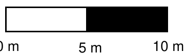
Key characteristics:
- Visual representation with marked distances (e.g. 0 m, 5 m, 10 m)
- Shows how many measured units equal specific actual distances
- Remains accurate even if the map is resized (the bar scale resizes proportionally)
Worked example - Bar scale calculation
Worked Example: Using Bar Scales for Distance Calculation
Question: Using a bar scale where 2 cm = 200 m, what actual distance does 15.5 cm represent?
Solution:
- From the bar scale: 2 cm = 200 m
- Therefore: 1 cm = 100 m
- For 15.5 cm: 15.5 × 100 m = 1 550 m
- Convert to kilometres: 1 550 m = 1.55 km
Answer: 1.55 km
Converting between scales and measurements
The relationship between plan measurements and real-world measurements follows consistent mathematical principles that apply regardless of the scale used.
Scale conversion table example
| Feature | Measure on Plan | Actual Real-World Measure |
|---|---|---|
| House Length | 14 cm | 7 m |
| House Width | 10.5 cm | 5.25 m |
| Wall Height | 4.4 cm | 2.2 m |
| Roof Height | 3 cm | 1.5 m |
| Door Height | 4 cm | 2 m |
Method for 1:50 scale:
- Scale 1:50 means actual measure = plan measure × 50
- Example: House length = 14 cm × 50 = 700 cm = 7 m
Understanding Scale Factors
The scale factor (50 in this case) tells you how many times larger the real world is compared to the plan. This same principle applies whether you're measuring buildings, distances, or any other features on a scaled drawing.
Exam tips and common mistakes
Critical Exam Strategies
- Always check units: Convert between cm, m, and km as needed
- Show your working: Include all calculation steps clearly
- Use appropriate units: Express actual distances in km or m, not cm
- Round sensibly: Give realistic precision for distance estimates
Common mistakes to avoid
Understanding these frequent errors will help you avoid losing marks in examinations:
- Forgetting to convert units (cm to m to km)
- Using wrong scale factor direction (multiplying instead of dividing)
- Not recognising that number scales become invalid when maps are resized
- Confusing bar scale measurements with the actual distances they represent
Bar Scale Advantage
Remember that bar scales remain accurate when maps are photocopied or resized, while number scales become inaccurate. This makes bar scales more reliable for practical use.
Remember!
Key Points to Remember:
- Map progression: National road maps → Strip-charts → Street maps → Housing complex maps (large area/less detail → small area/more detail)
- Two calculation types: Map measurement to actual distance, and actual distance to map measurement
- Scale types: Number scales (1:50 000) change when maps are resized; bar scales stay accurate when resized
- Distance estimation: Scales provide estimates, not exact distances, due to measurement limitations and route variations
- Unit conversion: Always convert properly between cm, m, and km - this is where many marks are lost in exams