Intervisibility (Grade 12 NSC Matric Geography): Revision Notes
Intervisibility
What is intervisibility?
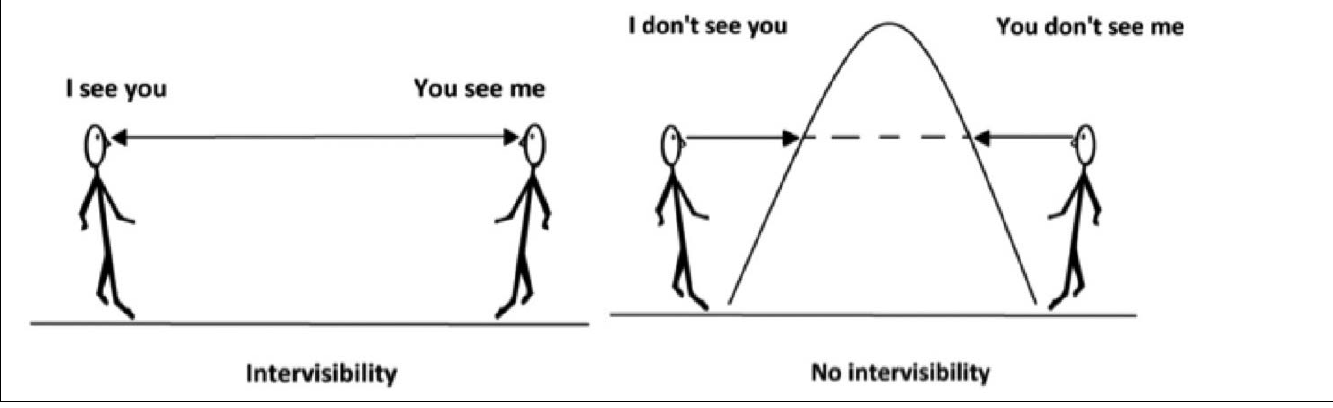
Intervisibility refers to the ability to see one location from another location. When we say two places have intervisibility, it means that if you were standing at one point, you would be able to see the other point clearly. Think of it like having a clear line of sight between two places.
The concept is quite simple to understand when we think about it in everyday terms. If you and a friend are standing on flat ground with nothing between you, you can see each other easily. However, if there's a large hill or mountain between you, you won't be able to see each other because the terrain blocks your view.
How does terrain affect intervisibility?
Terrain plays a crucial role in determining whether two places are intervisible. When the land between two points is flat or gently sloping, there's usually good intervisibility. However, when there are hills, mountains, or other elevated features between the two points, these obstacles can block the line of sight, preventing intervisibility.
This concept is particularly important in geography because it helps us understand how landscape features influence what we can see from different locations. It's also practical for activities like surveying, military planning, and even placing communication towers.
Method to determine intervisibility using cross-sections
When working with topographical maps and cross-sections, geographers use a systematic approach to determine if two places are intervisible. This method is especially useful when you can't physically visit the locations but need to analyse them using map data.

The Two-Step Method for Determining Intervisibility:
Step 1: Draw a straight line connecting the two points you want to analyse. This line represents the direct line of sight between the locations.
Step 2: Examine whether this line passes through any elevated terrain features shown in the cross-section. If the line cuts through hills, mountains, or other raised areas, then there is no intervisibility between the points. If the line passes above all terrain features without obstruction, then intervisibility exists.
Understanding the cross-sectional analysis
When you look at a cross-sectional diagram, you're seeing a side view of the landscape along a specific route. The curved line shows how the elevation changes from one point to another. Your job is to determine whether an imaginary straight line between two points would be blocked by any part of this terrain.
Worked Example 1: No Intervisibility
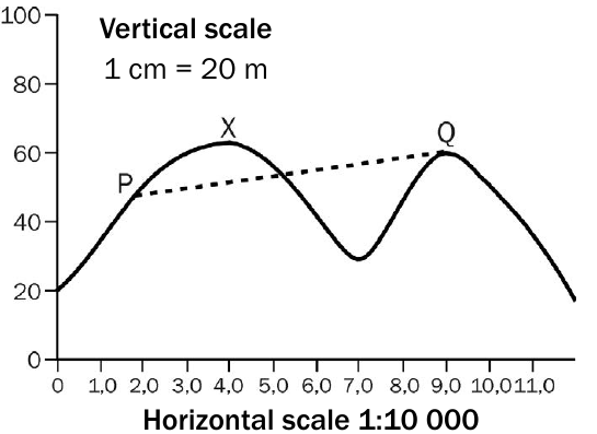
In this example, we're examining whether point P and point Q are intervisible. When we draw a straight line between these two points, we can see that the line passes directly through the elevated terrain (the mountain peak). This means that the terrain blocks the line of sight between P and Q, so there is no intervisibility between these locations.
From point P, you wouldn't be able to see point Q because the mountain is in the way. Similarly, from point Q, you couldn't see point P for the same reason.
Worked Example 2: Intervisibility Exists
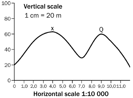
In this second example, we're checking if point X and point Q are intervisible. When we draw the straight line between X and Q, we notice that this line passes above all the terrain features without cutting through any elevated areas. The line clears the hills and valleys between the two points.
This means there is intervisibility between X and Q. Someone standing at point X would be able to see point Q, and vice versa, because no terrain features block their line of sight.
Key factors to consider
Critical Points for Intervisibility Analysis:
-
Scale matters: Pay attention to both the vertical and horizontal scales on the cross-section, as these affect how you interpret the terrain heights and distances.
-
Line position: The straight line you draw should connect the exact points being analysed, not just approximate locations.
-
Terrain interference: Even if the line barely touches a terrain feature, it still counts as no intervisibility because the obstacle would block the view.
- Real-world application: This concept applies to many practical situations, from determining the best locations for lookout points to planning communication networks.
Common exam tips
Examination Success Strategies:
In NSC examinations, intervisibility questions often provide you with a cross-sectional diagram and ask you to determine whether two specific points are intervisible. Always follow the two-step method systematically, and clearly state your reasoning in your answer.
Make sure you can explain why intervisibility does or doesn't exist based on whether the line of sight is obstructed by terrain features. Your explanation should reference the specific terrain that either blocks or allows the line of sight.
Key Points to Remember:
- Intervisibility means you can see one place from another place - it's about having a clear line of sight
- Draw a straight line between the two points you're analysing on the cross-section
- If the line cuts through any terrain features (hills, mountains), there is NO intervisibility
- If the line passes above all terrain without obstruction, intervisibility EXISTS
- Always explain your answer by referring to whether terrain blocks or allows the line of sight