Introduction to Mapwork Calculations (Grade 12 NSC Matric Geography): Revision Notes
Introduction to Mapwork Calculations
Understanding mapwork calculations
Mapwork calculations are essential skills that help you determine real-world measurements using topographic maps and orthophotos. These calculations allow you to find actual distances, areas, and height differences from map measurements. The key to success lies in understanding how different map scales affect your calculations.
When working with mapwork calculations, you'll encounter two main types of maps, each with different scales that require specific conversion methods. Understanding these scales is crucial because they determine how you convert measurements from the map to real-world distances.
The ability to accurately convert between map measurements and real-world distances is fundamental to all mapwork calculations. This skill forms the foundation for more complex geographical analysis and fieldwork applications.
Map scales and conversion factors
Maps use different scales to represent the real world, and each scale requires specific conversion factors for accurate calculations. The two most common types you'll work with are topographic maps and orthophoto maps.
Topographic maps (1:50 000 scale)
A topographic map uses a scale of 1:50 000, which means that 1 centimetre on the map represents 50 000 centimetres in the real world. This converts to:
- 1 cm on the map = 500 metres in reality
- 1 cm on the map = 0.5 kilometres in reality
Orthophoto maps (1:10 000 scale)
An orthophoto map uses a larger scale of 1:10 000, providing more detail than topographic maps. This scale means:
- 1 cm on the map = 100 metres in reality
- 1 cm on the map = 0.1 kilometres in reality
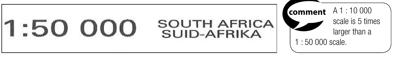
The orthophoto scale is five times larger than the topographic scale, which means it shows more detail and covers a smaller area than a topographic map of the same size. This increased detail makes orthophotos particularly useful for urban planning and detailed site analysis.
Conversion table for calculations
To make calculations easier, use these conversion factors depending on whether you need your answer in kilometres or metres. Always check which units the question requires before starting your calculation.
For topographic maps (1:50 000):
- To get kilometres: multiply by 0.5
- To get metres: multiply by 500
For orthophoto maps (1:10 000):
- To get kilometres: multiply by 0.1
- To get metres: multiply by 100
Basic calculation methods
Distance calculations
Distance calculations help you find the straight-line distance between two points or the actual distance along features like roads or rivers.
Formula: Actual Distance = Map Distance × Scale (AD = MD × S)
Method for calculating distance:
Step-by-Step Distance Calculation Method:
Step 1: Measure the map distance in centimetres using a ruler or the edge of a piece of paper.
Step 2: Apply the correct conversion factor:
- For topographic maps: multiply by 0.5 for kilometres or by 500 for metres
- For orthophoto maps: multiply by 0.1 for kilometres or by 100 for metres
Height difference calculations
Height differences show the vertical distance between two points with different elevations. This is useful for understanding terrain steepness and relief.
To calculate height difference, simply subtract the smaller height value from the larger height value.
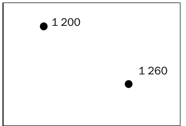
Worked Example: Height Difference Calculation
If you have two spot heights of 1 200m and 1 260m: Height difference = 1 260 - 1 200 = 60 metres
Straight line distance example
Here's a practical example using the elevation points shown above:
Worked Example: Complete Distance Calculation
If the map distance between spot heights 1 200m and 1 260m measures 2.4 cm on a 1:50 000 topographic map:
Calculation:
- Map distance = 2.4 cm
- Scale factor for kilometres = 0.5
- Actual distance = 2.4 × 0.5 = 1.2 km
Common Mistakes to Avoid:
- Always check which type of map you're working with before starting calculations
- Pay attention to whether the question asks for answers in metres or kilometres
- Using the wrong conversion factor is the most common error in mapwork calculations
- Remember that orthophoto maps provide more detail due to their larger scale
- Show all your working steps clearly in exams
- Double-check your conversion factors before proceeding
Key Points to Remember:
- Topographic maps (1:50 000): Use 0.5 for km or 500 for metres
- Orthophoto maps (1:10 000): Use 0.1 for km or 100 for metres
- Distance formula: Actual Distance = Map Distance × Scale
- Height difference: Always subtract smaller from larger height
- Orthophoto scale is 5 times larger than topographic scale, showing more detail