Map Sheet References / Map Code (Grade 12 NSC Matric Geography): Revision Notes
Map Sheet References / Map Code
What are map sheet references?
A map sheet reference acts as the title or name of a topographical map. This reference system helps us identify exactly which area of South Africa a particular map covers and connects it to all other South African maps in a systematic way.
Think of map sheet references as a postal address system for maps - each reference tells you precisely where that map fits within the larger mapping system of the country.
Understanding the components
Every map sheet reference contains both numbers and letters that have specific meanings. Let's examine the example 3318CD to understand how this system works.
The numbers (3318)
The four numbers in a map sheet reference indicate where lines of latitude and longitude intersect:
- The first two numbers (33) represent the latitude line
- The last two numbers (18) represent the longitude line
- This creates a specific intersection point that helps locate the map area
The letters (CD)
The letters refer to how the area is divided into manageable sections called blocks:
- The area within the latitude and longitude lines is split into four large squares
- These are called big blocks and are labelled A, B, C, and D
- Each big block is then subdivided into four smaller squares
- These are called small blocks and are also labelled A, B, C, and D
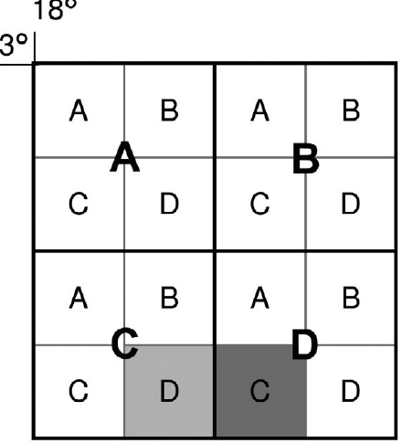
Worked Example: Decoding 3318CD
Let's break down the reference 3318CD step by step:
Step 1: Identify the coordinates
- 33 = latitude line (33°)
- 18 = longitude line (18°)
Step 2: Identify the block divisions
- C = big block C within the coordinate area
- D = small block D within big block C
Result: This map covers small block D of big block C at the intersection of 33° latitude and 18° longitude.
How the grid system works
The South African mapping system uses a clever grid arrangement that makes it easy to locate adjacent maps. Here's how it functions:
When you look at any map area, you'll see it divided into sections following this pattern:
- Four big blocks arranged in a 2×2 grid (A, B, C, D)
- Each big block contains four small blocks, also in a 2×2 arrangement (A, B, C, D)
This creates a systematic way to reference any specific area within the larger geographical region.
Finding adjacent map sheet references
One of the most important skills in mapwork is determining the map sheet references for areas adjacent to a given reference. Let's work through how this process works using practical examples.
Moving east from 3318CD
When you need to find the map sheet reference to the east of 3318CD:
- The block to the east falls within the same latitude and longitude area
- So the numbers (3318) remain the same
- However, it moves into big block D
- Therefore, the reference becomes 3318DC
Moving in different directions
Essential Rules for Finding Adjacent Map References:
Moving North: If you go north (up) out of a big block, the latitude must decrease by 1°
Moving South: If you go south (down) out of a big block, the latitude must increase by 1°
Moving East: If you go east (right) out of a big block, the longitude must increase by 1°
Moving West: If you go west (left) out of a big block, the longitude must decrease by 1°
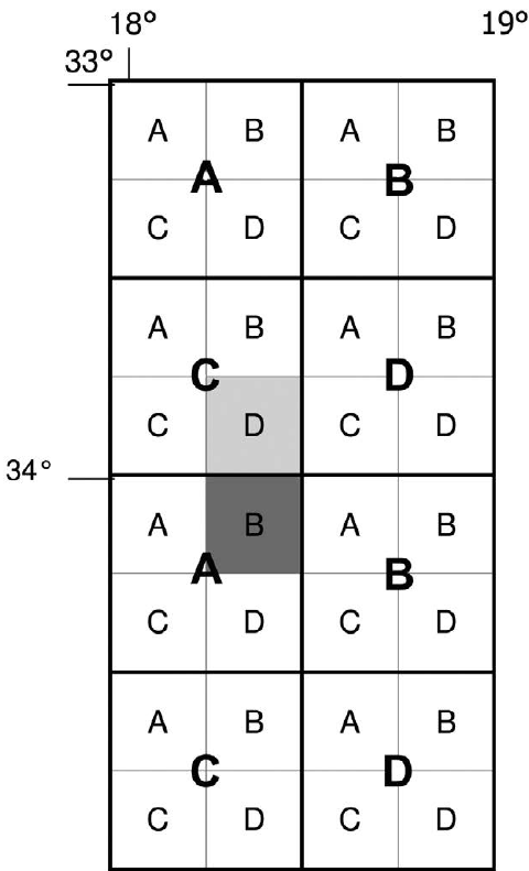
Worked Example: Moving South from 3318CD
Let's trace through finding the reference south of 3318CD:
Step 1: Determine coordinate changes
- Moving south takes us out of the 33° latitude area
- Latitude increases by 1°: 33° → 34°
- Longitude stays the same: 18°
Step 2: Determine new block position
- We enter big block A in the new coordinate area
- We're moving to small block B within that big block
Step 3: Write the new reference
- New coordinates: 34 and 18
- New blocks: A and B
- Final answer: 3418AB
Common exam question types
The NSC Geography exam typically includes two main types of questions about map sheet references:
Type 1: Direct identification "What is the map sheet reference of the map?"
- Look at the top of the map or front page to find this information
- It will be clearly displayed as the map's title
Type 2: Adjacent reference calculation
"Name the map sheet reference in any direction from the given map sheet reference"
- Use the coordinate change rules explained above
- Work systematically through the latitude and longitude changes
- Remember to adjust the block letters appropriately
Exam tips and strategies
When answering map sheet reference questions in exams, these strategies will help ensure success:
Critical Exam Success Tips:
-
Always check your coordinate logic: Make sure latitude and longitude changes follow the correct direction rules
-
Double-check block positions: Ensure you understand whether you're moving between big blocks or into entirely new coordinate areas
-
Practice with different examples: The more you work with various starting positions, the more confident you'll become
-
Look for grid references on exam maps: Many topographical maps include small grid references at the bottom that can help verify your answers
-
Remember the latitude rule: Latitude (N or S) is always written first in coordinates
Key Points to Remember:
-
Map sheet references serve as unique identifiers that connect individual maps to the broader South African mapping system
-
The four numbers represent latitude and longitude intersections, while letters indicate block divisions within those areas
-
When moving between adjacent maps, latitude decreases going north and increases going south, while longitude increases going east and decreases going west
-
Big blocks and small blocks both use the same A, B, C, D labelling system in a 2×2 arrangement
-
Exam success requires understanding both direct identification of references and systematic calculation of adjacent references using coordinate change rules