Urban Settlements (Grade 12 NSC Matric Geography): Revision Notes
Urban Land Use Zones
Urban areas are organised into different zones based on their primary functions and characteristics. Understanding these zones helps us make sense of how cities are structured and how different areas serve various purposes for the people who live and work there.
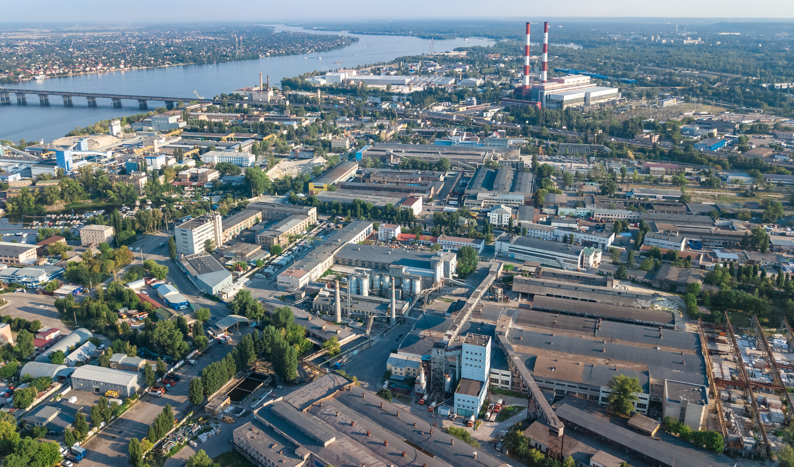
An orthophoto is an aerial photograph that has been geometrically corrected so that the scale is uniform and there is no visual distortion. Remember, aerial means 'seen from above'. These images, along with regular photographs, help us identify and understand different urban land use zones.
Orthophotos are particularly valuable for urban planning because they provide accurate, distortion-free images that allow planners to measure distances and areas precisely. This makes them essential tools for studying land use patterns and city development.
Main urban land use zones
Cities contain several distinct zones, each with unique characteristics and functions. Let's explore each one in detail:
Remember that while cities generally follow these zoning patterns, real urban areas are complex and zones often overlap or blend together. No city perfectly matches theoretical models, but understanding these zones helps us analyse urban structure.
Central Business District (CBD)
The Central Business District forms the heart of any urban area and serves as the main commercial and business centre.

Key characteristics:
- Located at the heart of the city
- Features the highest land values due to prime location and accessibility
- Most accessible area with excellent transport connections
- Contains the highest building density with structures built close together
- Home to the tallest buildings and skyscrapers
- Primary location for offices, banks, shops, and government buildings
The CBD attracts businesses because of its central location and excellent transport links, making it easy for customers and workers to reach. However, the high demand for space drives up land prices, which is why buildings grow upward rather than outward.
Transition zone
The transition zone acts as a buffer between the CBD and residential areas, often characterising mixed land use patterns.
Key characteristics:
- Contains mixed and changing land use, such as residential areas becoming commercial
- Often experiences urban decay with deteriorating buildings
- Landlords frequently neglect maintenance of properties and buildings
- Working class residents typically live here in high-density flats or small houses
- Buildings may show signs of structural problems or abandonment
The transition zone is dynamic and constantly evolving. What appears as residential today might become commercial tomorrow as the city grows and land values change. This makes it one of the most interesting areas to study urban development patterns.
This zone often represents areas undergoing change, where the original residential function is gradually being replaced by commercial or light industrial uses as the city expands.
Light industry
Light industrial zones provide space for manufacturing that doesn't heavily pollute the surrounding environment.
Key characteristics:
- Often located near the CBD or in specially planned industrial estates
- Government typically provides necessary infrastructure like power and transport
- Situated near road transport networks for easy movement of raw materials
- Produces minimal noise and air pollution compared to heavy industry
- Includes factories producing goods like textiles, electronics, or food processing
These areas are strategically placed to balance accessibility with environmental considerations, ensuring businesses can operate efficiently without severely impacting nearby residential areas.
Heavy industry
Heavy industrial zones accommodate large-scale manufacturing that requires significant space and produces substantial pollution.
Key characteristics:
- Located on city outskirts where land costs are lowest
- Positioned near major road and rail networks for transporting raw materials and finished products
- Often associated with nearby low-income housing for workers
- Generates heavy air and noise pollution that affects surrounding areas
- Requires flat land and access to water sources for operations
- Includes facilities like steel plants, chemical refineries, and large manufacturing complexes
Heavy industry is deliberately located on the periphery to minimise pollution impact on urban populations. This spatial separation is crucial for public health and quality of life in cities.
The peripheral location helps minimise the impact of pollution on the main urban population whilst providing the space and infrastructure these industries need.
Middle to high-income residential areas
These zones house the city's more affluent residents and reflect higher living standards.
Key characteristics:
- Located away from the CBD to avoid noise and pollution
- Often situated in areas with pleasant environments and good access
- Features townhouses and large individual houses with gardens
- Larger properties due to more available and affordable space
- Excellent services and facilities, including recreational areas, good schools, and healthcare
- Well-maintained infrastructure and landscaping
Wealthy residents can afford to live further from the city centre and typically have private transport, allowing them to choose locations that offer better quality of life.
Low-income residential areas
These zones provide housing for working-class residents, often with more basic amenities.
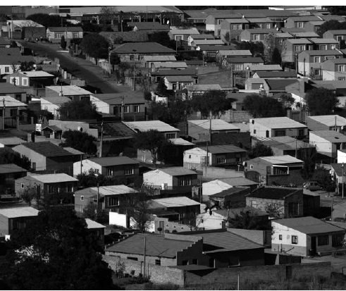
Key characteristics:
- Buildings constructed very close together to maximise land use
- Located close to business areas and industrial zones for employment access
- Limited facilities and poorer quality services
- Smaller residential blocks and houses
- Buildings often have similar, basic designs
- Less green space and recreational facilities
These areas develop to provide affordable housing for workers who need to live close to their places of employment but cannot afford the higher costs of better-located housing.
Informal settlements
Informal settlements represent areas where people have established homes without official planning or services.
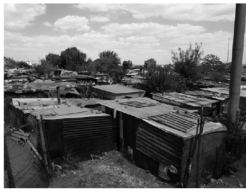
Key characteristics:
- Located on city outskirts, often on unsuitable or marginal land
- Lack basic service delivery including roads, sanitation, water supply, electricity, and schools
- Experience high poverty levels and unemployment
- Face elevated crime rates due to social and economic challenges
- Houses constructed from available materials like plastic, wood, corrugated iron, and other recycled materials
- Unhealthy living conditions due to overcrowding and lack of services
- Very dense housing with unplanned street patterns
Informal settlements are not simply problems to be solved, but communities where people demonstrate remarkable resilience and resourcefulness. Understanding them requires recognising both their challenges and the strength of their communities.
These settlements often emerge when people migrate to cities seeking economic opportunities but cannot afford formal housing, leading them to create their own communities on available land.
Green belt and recreation areas
Green belts provide essential open spaces within urban environments.
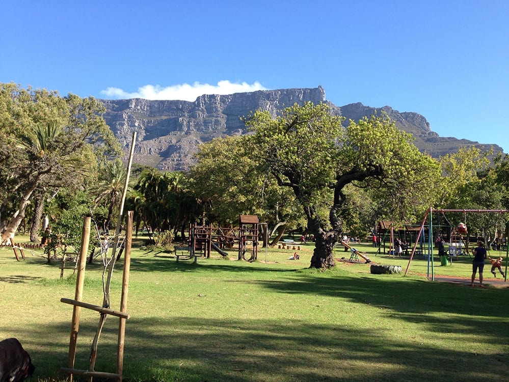
Key characteristics:
- Contain no permanent buildings or structures
- Used for public gardens, parks, and sports fields with many trees and lawns
- Help clean the air in urban areas by absorbing pollution
- Calm traffic and reduce noise levels in surrounding areas
- Provide recreational opportunities for urban residents
- Offer visual relief from dense urban development
These areas are crucial for urban sustainability and quality of life, providing environmental benefits and spaces for recreation and relaxation.
Rural urban fringe
The rural urban fringe represents the boundary area where urban and rural activities meet and blend.
Key characteristics:
- Mixed land use combining both urban and rural functions
- Contains urban functions like rubbish dumps, airports, cemeteries, and golf courses
- Land use gradually changing from rural to urban as the city expands
- Features larger properties because land is often cheaper than in central areas
- Less developed areas with more open space
- Includes plots and smallholdings that may be used for agriculture or rural activities
This zone represents the dynamic edge of urban growth where rural land is gradually converted to urban uses.
Urban land use models
Land use models are simplified diagrams that help us understand and represent the patterns of land use functions within cities and towns.
It's crucial to remember that these models are simplifications of reality, and it's unlikely that any single model will perfectly fit every town or city. They are tools for understanding general patterns, not exact blueprints.
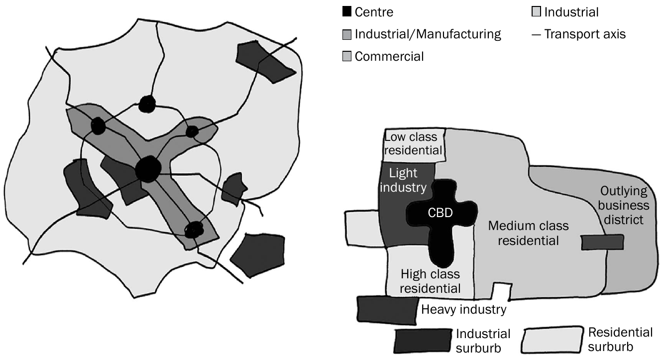
Multiple nuclei model
Most modern cities fit the multiple nuclei model, which recognises that cities have several centres or "nuclei" rather than just one central area. This reflects how cities have grown and developed multiple business districts, shopping centres, and activity nodes.
American-Western city model
This model represents the typical development pattern seen in many Western cities, with distinct zones radiating from a central core and connected by transport networks.
Third world city model (Latin American)
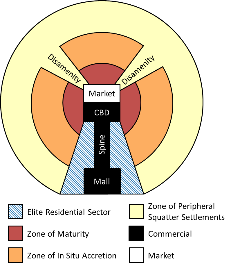
This model shows the urban structure common in developing countries, particularly Latin American cities. It includes:
- Central market and CBD
- Elite residential sectors
- Middle-class residential areas
- Zones of in-situ accretion (gradual improvement)
- Zones of maturity
- Areas undergoing gentrification
- Peripheral squatter settlements
South African apartheid city model
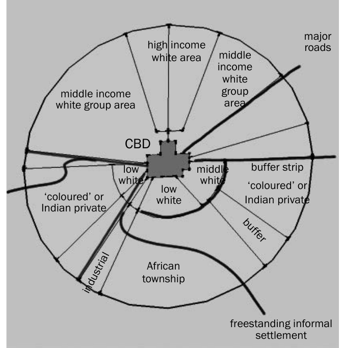
South African cities developed a unique pattern due to apartheid legislation, particularly the Group Areas Act. This created a multiple nuclei pattern with specific modifications including racially segregated residential areas, buffer strips between different racial groups, and systematic spatial separation.
The South African model demonstrates how political and social policies can dramatically shape urban structure. Even after apartheid ended, many cities still show these spatial patterns, highlighting how urban form can persist long after the policies that created it have changed.
As cities developed and changed over time, urban planners created these models to represent different patterns of land use. Today, most cities follow some version of the multiple nuclei model, though developing countries often show different patterns with well-developed planned areas alongside unplanned, informal settlements that grew due to rural-urban migration.
Identifying land use zones on maps
Understanding how to identify land use zones on topographic maps and orthophotos is crucial for examinations and real-world applications.
Worked Example: Identifying Zones on a Map
When examining a topographic map to identify the CBD:
- Look for the centre of the town or city
- Identify the gridiron (grid-like) street pattern
- Notice where multiple transport routes converge
- Check for the highest density of buildings (shown as closely packed structures)
Result: The area meeting all these criteria is your CBD.
Central Business District:
- Located in the centre of the town
- Shows a gridiron street pattern
- Multiple transport routes converge here
Working class residential zones:
- Situated near CBD, industrial areas, sewage works, or railway lines
- Appear as very small blocks on maps (grey blocks show built-up areas)
Upper class residential areas:
- Found on town outskirts, away from factories and sewage works
- Located near amenities like golf courses or the sea
- Shown as large grey blocks on maps
Heavy industry:
- Positioned on town outskirts
- Located next to main transport routes (highways or railways)
- Often situated near rivers for water access
- Indicated by large black blocks on maps
In Paper 1 and Paper 2 examinations, you may be asked to identify land use zones in diagrams, cartoons, photographs, or on topographic maps and orthophotos. Practice identifying the key visual clues that distinguish each zone type.
Remember that in Paper 1 and Paper 2 examinations, you may be asked to identify land use zones in diagrams, cartoons, photographs, or on topographic maps and orthophotos. You might also need to describe the characteristics of specific land use zones.
Remember!
Key Points to Remember:
- Urban land use zones are areas within cities that serve specific functions and have distinct characteristics
- The CBD is the heart of the city with the highest land values, tallest buildings, and best accessibility
- Residential zones vary by income level, with wealthy areas featuring larger properties away from pollution sources
- Industrial zones are divided into light (less polluting, closer to city) and heavy (more polluting, on outskirts) categories
- Land use models help us understand city structure, with the multiple nuclei model being most applicable to modern cities
- Map interpretation skills are essential for identifying different zones using features like building density, transport routes, and location relative to city centre