Case Study: The Cheonggyecheon River Project, South Korea (AQA A-Level Geography): Revision Notes
Case Study: The Cheonggyecheon River Project, South Korea
Background and context
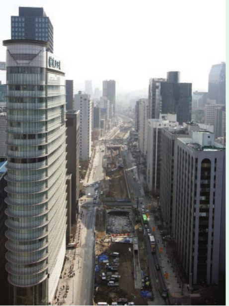
Seoul is one of the world's largest cities. It has a population of over 10 million people, with 24.5 million living in the wider metropolitan area. The city is also one of the most densely populated urban centres globally, with more than 17,000 people per square kilometre.
At the heart of Seoul lies the Cheonggyecheon, originally a small seasonal stream. Over time, this waterway became increasingly built over and hidden beneath urban development. The stream eventually disappeared under concrete and traffic infrastructure.
The extreme population density of Seoul created immense pressure on urban infrastructure throughout the 20th century. This density - roughly equivalent to fitting the entire population of a small country into a single metropolitan area - drove many of the development decisions that ultimately covered the Cheonggyecheon stream.
Historical development of the stream
The transformation of the Cheonggyecheon occurred in several stages, reflecting broader changes in Korean society and urban planning priorities:
Timeline: From Natural Stream to Urban Infrastructure
-
1918: The Japanese colonial administration began dredging the stream. The aim was to reduce sanitation problems and flood risks in the area.
-
World War II and Korean War: All work on the stream stopped. Refugees and returning residents established squatter communities along the stream's banks during this period.
-
1958-1961: Authorities fully covered the stream. This was done to manage the growing urban population and development pressures.
-
1971: A four-lane elevated freeway (overpass) was built on top of the covered stream. This continued until 2003.
-
2003: The government launched an ambitious restoration scheme. The two-year project cost $281 million and aimed to transform the area into a 5.8 km ecologically sensitive green pedestrian corridor.
Reasons for and aims of the project
Changing urban priorities
Seoul's development priorities shifted significantly. The city moved away from car-dependent urban planning towards valuing quality of life and healthy ecosystems. This change reflected broader shifts in South Korean planning priorities during the second half of the twentieth century.
Previously, the country focused on rapid industrialisation and modernisation. By the early twenty-first century, there was greater emphasis on health, sustainability and social responsibility from both authorities and residents.
Specific problems identified
Several critical issues made the restoration project not just desirable but necessary:
Safety concerns: The ageing elevated freeway and concrete deck posed serious safety risks. The structure needed major repairs or complete removal.
Poor connectivity: The freeway divided Seoul's north and south sides, making it difficult for people to move between these areas.
Economic decline: Over 100,000 small businesses operated in the areas next to the overpass. The structure seriously damaged their competitiveness. By the end of the twentieth century, buildings were deteriorating, pollution was severe, and green space was almost non-existent.
Project objectives
The restoration aimed to achieve multiple interconnected goals:
- Create ecological and recreational opportunities along a 5.8 km corridor through central Seoul
- Improve connectivity between the city's north and south areas
- Restore ecosystem functions in the damaged urban catchment
- Transform the area into a space that residents could enjoy and use
The project represented a fundamental shift in urban planning philosophy - from prioritising vehicle movement to prioritising human and ecological wellbeing. This represented a bold reimagining of what a modern city centre could be.
Description of work carried out
Infrastructure removal and bridge construction
The project began by dismantling the elevated freeway and concrete deck that covered the stream. This massive engineering undertaking cleared the way for the stream's restoration. Authorities then built 22 new bridges:
- 12 pedestrian bridges
- 10 bridges for both cars and pedestrians
These bridges improved north-south movement across the area while allowing the stream to flow freely beneath them.
Transport improvements
To address concerns about removing the elevated highway, several compensatory measures were implemented:
- Rapid bus lanes were added in car-discouraged areas
- Loading and unloading systems for businesses improved
- These changes were implemented to maintain connectivity
Transportation experts were initially skeptical that the city could remove a major arterial road carrying 169,000 vehicles daily without creating traffic chaos. The careful planning of alternative transport options proved crucial to the project's success.
Water management
The Cheonggyecheon is seasonal, so water flow varies throughout the year. To address this challenge and ensure year-round water presence:
- Water is pumped from the nearby Hanang River to the restoration area
- This creates consistent flow with an average depth of 40 cm
- The water undergoes treatment to ensure it remains unpolluted
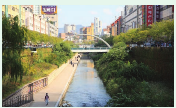
Three-zone ecological design
The corridor runs from Seoul to an ecological conservation area outside the city. The design divides into three distinct zones marking the gradual transition from urban to natural landscape:
The Three-Zone Approach: Urban to Natural Transition
Zone 1 - Central historic zone:
- Underground waterways were redirected to create a new stream bed
- Banks were landscaped
- Foundations and stones from earlier structures were included as decorative elements
- Seating throughout encourages public use
Zone 2 - Middle recreation areas:
- Features waterfront decks and stepping stones bridging the two banks
- Design focused on environmentally friendly materials
- Includes fountains and waterfalls
Zone 3 - Final natural zone:
- Stream widens and is designed to look overgrown and natural
- Sections of the pier and overpass were left as industrial monuments
- Area where the stream joins the Hanang River becomes a wetland conservation area
Stakeholder attitudes and contributions
Successful urban projects require buy-in from multiple stakeholder groups. The Cheonggyecheon restoration demonstrates how different perspectives can be managed and integrated.
Political leadership
South Korean President Lee Myung Bak championed the restoration. He included it in his successful campaign to become Mayor of Seoul in 2001. Once elected, it became a priority for his administration. His political commitment provided the momentum and resources needed to overcome significant obstacles.
Transportation experts
Transport experts worried that removing the elevated highway would increase traffic congestion and chaos in the northern end of the city. The area already carried 169,000 vehicles daily. Authorities had to carefully address these concerns through detailed traffic modelling and planning of alternative routes.
Cheonggyecheon Restoration Citizens' Committee
A committee of professionals and citizen groups took responsibility for gathering public opinion. Their role proved crucial in maintaining public support:
- Communicated the project's goals clearly
- Organised public information sessions
- Ensured community voices were heard throughout the process
The Citizens' Committee served as a vital bridge between government planners and ordinary residents. Their work in explaining the project's benefits and addressing concerns helped prevent the kind of public opposition that has derailed similar projects in other cities.
Local businesses
Many local businesses initially saw the project as either an interruption or threat to their livelihoods. The Citizens' Committee responded proactively:
- Surveying markets in detail
- Conducting interviews with affected business owners
- Holding regular consultation meetings
To minimise disruption and encourage business activity, the Seoul Metropolitan Authority implemented comprehensive support measures:
- Provided extra parking
- Reduced parking fees
- Improved loading and unloading systems
- Promoted Cheonggyecheon businesses through marketing
- Provided support, subsidies and grants for business restructuring
- Struck special arrangements with businesses that had to relocate
Evaluation of the project
Tourism and recreation impacts
Since restoration, Cheonggyecheon has become extremely popular with both residents and visitors. People use it for rest and relaxation. The stream became a major tourist attraction, drawing an estimated 18.1 million visitors by the end of 2008.
Public facilities, such as the Dongdaemun plaza and various seating areas, have encouraged diverse cultural programming. Parts of the project have become well-known as lively and accessible venues. The Cheonggyecheon Museum, situated on the embankment, features permanent and temporary exhibitions about the area's history and reconstruction.
The visitor numbers exceeded all expectations. To put this in perspective, 18.1 million visitors in the first few years represents more than the entire population of Seoul itself - demonstrating the stream's appeal to both residents and tourists from around the world.
Economic sustainability
Despite its central location, the area had fallen behind the rest of Seoul economically before the restoration. Since the project ended, the economic transformation has been remarkable:
- Development capital has been invested in residential construction
- Property prices have risen at double the rates elsewhere in the city
- The number of businesses in areas closest to the restoration work has increased
- This contrasts with decreasing business trends in most other city districts
The economic viability of the project proved doubters wrong. Rather than harming local businesses, the restoration created a more attractive environment that drew investment and customers. Property values rising at double the city average demonstrates the significant economic value created by prioritising public space and environmental quality.
Traffic impacts
Traffic in the central business district slowed by only 12.3%. This relatively small decrease surprised many who predicted major congestion problems.
Positive changes included:
- Increased bus and subway train usage
- The stream area has become a more attractive alternative to street-level journeys
- More pedestrian activity in the area
Removing large numbers of cars from this artery created a 2.5°C reduction in average temperatures. Air flows freely along the stream's path, creating a cooling wind corridor. A 2005 public survey showed respondents overwhelmingly noticed improvements in air and water quality, noise levels and smells.
The temperature reduction of 2.5°C might seem modest, but in a densely built urban environment during hot summers, this represents a significant improvement in thermal comfort. The stream essentially functions as a natural air conditioning system for the surrounding area.
Environmental benefits
The restoration brought significant ecological improvements that transformed the area into an urban wildlife haven:
- Lost habitats have been re-established
- Plant and animal species have reappeared
- The area has become an urban wildlife haven
- Schoolchildren now have access to a valuable educational resource
- Ecology is embedded seamlessly within the urban environment
The return of wildlife to the corridor demonstrates successful ecosystem restoration. The stream now serves as an ecological corridor, allowing species to move through the urban environment - something particularly valuable for birds and insects that need connected green spaces.
Inclusive design challenges
Despite the project's many successes, the design had significant limitations regarding accessibility:
Accessibility Concerns
The design had limited consideration of certain user groups, particularly:
- Older people
- People with visual impairments
- People with mobility problems
In September 2005, a group led a protest march demanding the right to access the new pathways alongside the stream.
In response, authorities provided lifts at seven locations. Free wheelchairs were also made available for users with mobility problems. However, despite these additions:
- Irregular surfaces remain uncomfortable for wheelchair users
- Poorly lit and congested tunnels are difficult for people with visual impairments to navigate
This represents a significant gap in what was otherwise intended to be a public space for all residents.
Key Points to Remember:
-
The Cheonggyecheon restoration transformed a $281 million elevated freeway into a 5.8 km ecological corridor through the heart of Seoul, featuring 22 bridges and three distinct zones.
-
The project balanced multiple stakeholder needs through careful consultation with transport experts, local businesses (100,000 affected), and citizens' committees, providing subsidies and support to minimise disruption.
-
Environmental and economic benefits were substantial: the area attracted 18.1 million visitors by 2008, temperatures dropped by 2.5°C, air quality improved, wildlife returned, and local property values doubled compared to other districts.
-
Traffic impacts were less severe than predicted, with speeds reducing by only 12.3%, while bus and subway usage increased as the corridor became an attractive alternative route.
-
Accessibility remained a significant weakness: despite adding lifts and wheelchairs at seven locations, irregular surfaces and poorly lit tunnels continue to create challenges for older people and those with mobility or visual impairments.