Urban Drainage (AQA A-Level Geography): Revision Notes
Urban Drainage
Urban drainage is essential for removing surface water runoff from built-up areas. Traditional underground pipe systems were designed to carry water away as quickly as possible. However, these systems were not designed with consideration for water quality, amenity value, landscaping potential, or wildlife habitats. Modern urban drainage must address these environmental concerns alongside flood prevention.
The shift from traditional to modern urban drainage represents a fundamental change in approach - from simply removing water quickly to managing it sustainably while providing environmental and community benefits.
Urban hydrology
Urban areas significantly alter natural water cycles. Understanding these changes is crucial for managing water in cities effectively.
Precipitation and infiltration in urban areas
Precipitation falls in greater amounts and with greater intensity in towns and cities compared to surrounding rural areas. In natural landscapes like forests, wetlands, and grasslands, rainfall is trapped by vegetation and slowly infiltrates into the ground. This natural process allows water to be stored in the soil and replenish groundwater supplies.
In contrast, impermeable urban surfaces fundamentally change this process. Roads, car parks, and rooftops prevent precipitation from infiltrating into the ground. Most water remains on the surface where it runs off rapidly in unusually large amounts.
Urban design features that accelerate runoff
Urban areas are deliberately designed to shed water quickly:
- Sloping roofs direct water to guttering systems
- Smooth, rounded gutters channel water efficiently
- Cambered roads (roads that slope from the centre to the edges) move water to drains
- Storm sewer systems act like high-density drainage networks underground
Water is gathered in these storm sewer systems, which function similarly to fast-moving underground drainage systems. The water gains speed and erosional power as it travels underground. When it leaves the storm drains and enters streams, the discharge happens very rapidly.
Changes to the water cycle
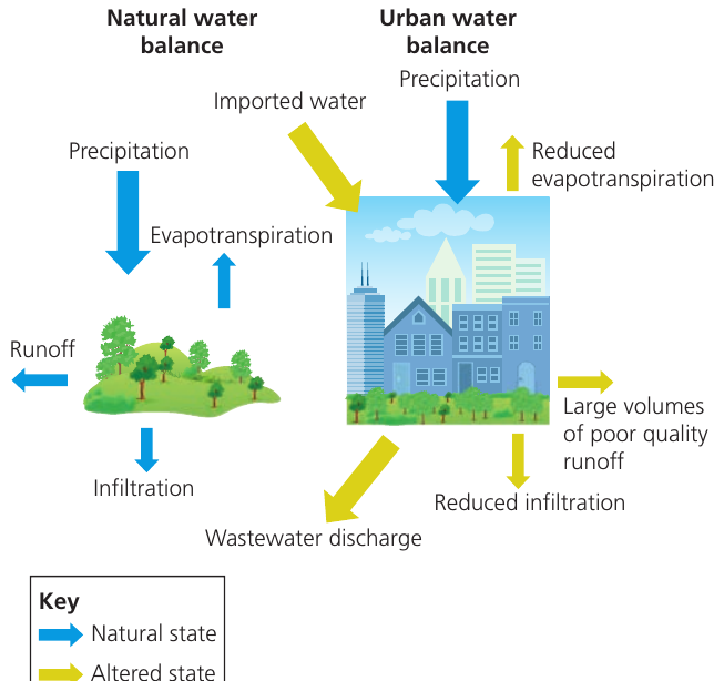
The diagram above shows how urbanisation fundamentally alters the water balance:
In natural environments:
- Precipitation infiltrates into the ground
- Evapotranspiration occurs from plants and soil
- Runoff is gradual and limited
- Wastewater doesn't exist
In urban environments:
- Imported water enters the system (from reservoirs, treatment plants)
- Evapotranspiration is greatly reduced (fewer plants, less vegetation)
- Infiltration is significantly reduced (impermeable surfaces)
- Large volumes of poor quality runoff occur
- Wastewater discharge is added to the system
Because much precipitation cannot infiltrate through impermeable surfaces, groundwater and soil water storage levels are reduced. This stored water normally feeds streams during dry periods, maintaining base level flows. The reduced groundwater storage means urban rivers have a flashy discharge pattern with low base flow.
Flashy discharge describes a river that rises and falls very quickly in response to rainfall, with high peak flows but very low flows during dry periods. This pattern dramatically increases flood risk in urban areas.
Storm hydrographs
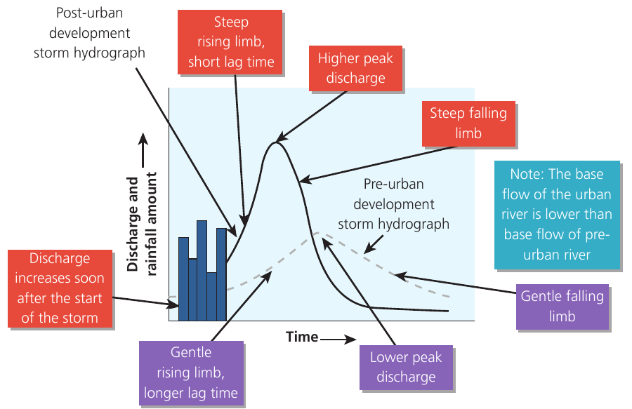
The storm hydrograph above clearly shows how urban development changes river behaviour:
Pre-urban development characteristics:
- Gentle rising limb (water reaches the river slowly)
- Longer lag time (delay between peak rainfall and peak discharge)
- Lower peak discharge (maximum flow is modest)
- Gentle falling limb (water level decreases gradually)
- Higher base flow (consistent water supply from groundwater)
Post-urban development characteristics:
- Steep rising limb (water reaches the river very quickly)
- Short lag time (minimal delay between rainfall and peak discharge)
- Higher peak discharge (much greater maximum flow)
- Steep falling limb (rapid decrease in water level)
- Lower base flow (reduced groundwater supply means less water during dry periods)
The diagram notes that "discharge increases soon after the start of the storm" in urban areas. This rapid response greatly increases flood risk.
Catchment management in urban areas
Managing urban catchments involves more than just controlling floods. Several interconnected issues must be addressed.
Increased flood risk
The combination of population growth, urban expansion, and climate change has put many more people at risk from flooding. According to the Asian Development Bank, the Asian population vulnerable to inland flooding is expected to reach 350 million by 2025.
Cities are particularly at risk because they are often sinking under their own weight. In Jakarta, a city of 9.6 million people, groundwater extraction has caused the ground to subside by 2.5 metres in less than a decade. The sprawling, growing city is literally sinking, making flooding problems much worse.
Issues with urban river catchment
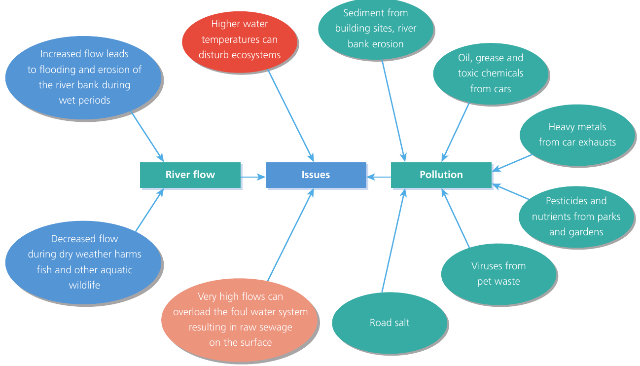
The diagram above illustrates the complex problems facing urban rivers. These issues fall into two main categories:
River flow problems:
- Increased flow during wet periods leads to flooding and erosion of river banks
- Decreased flow during dry weather harms fish and other aquatic wildlife
- Higher water temperatures disturb ecosystems (less vegetation means less shade, impermeable surfaces heat up and warm runoff)
- Very high flows can overload foul water systems, resulting in raw sewage being discharged onto the surface
Pollution sources:
- Sediment from building sites and river bank erosion
- Oil, grease, and toxic chemicals from cars
- Heavy metals from car exhausts
- Road salt (used for de-icing in winter)
- Pesticides and nutrients from parks and gardens
- Viruses from pet waste
Once pollutants wash into rivers or infiltrate into the ground, groundwater becomes extremely difficult to clean up. This is why preventing pollution at source is so important.
Traditional approaches to urban drainage
Case study: Los Angeles River
The Los Angeles River provides a clear example of traditional "hard engineering" approaches to flood management.
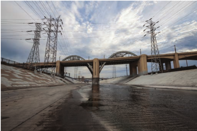
The LA River channel was designed to be fail-safe. Following devastating flash flooding in the 1930s, city authorities decided to convert the natural, meandering river into a cement and concrete controlled channel.
While directing the river through this built channel has helped control flooding, it has removed the ecosystem services that a river typically provides. Rivers naturally support wildlife, provide recreational opportunities, regulate water temperature, filter pollutants, and create attractive landscapes. The concrete channel offers none of these benefits.
The entire structure could be paralysed if one part sustains significant damage, such as from an earthquake. This creates a single point of failure for the entire flood management system - the very problem that "fail-safe" engineering tries to prevent.
Sustainable urban drainage systems (SUDS)
Sustainable urban drainage systems (SUDS) deliver a more holistic approach to managing surface water. Wherever possible, they mimic natural drainage processes.
SUDS represents a shift from "fail-safe" engineering to a "safe-to-fail" philosophy. Rather than trying to control water completely, SUDS works with natural processes to:
- Reduce flooding
- Control flooding during extreme events
- Provide amenity for the community
- Improve water quality
- Support biodiversity
How SUDS works
SUDS uses natural processes in the landscape to slow water movement and increase infiltration:
Water butts: Roofwater is collected in large containers (water butts) for later use in gardens. This reduces the volume of water entering the drainage system immediately after rainfall.
Swales: These are grass channels that water flows through. The grass and soil slow the water down and allow some infiltration before the water reaches local ditches. Swales also provide green space amenity.
Grass basins: Water flows onto grass basins where it is temporarily stored before being gradually released into the drainage system. The vegetation filters out some pollutants.
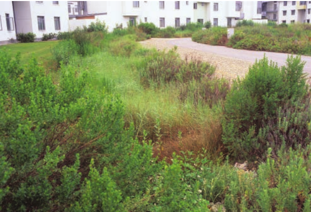
Bioswale rain gardens: These are sloped retention areas designed to capture and convey water while allowing infiltration. The example shown is a bioswale rain garden that allows water to infiltrate the ground slowly over a 24 to 48-hour period. Some water is taken up by the vegetation, which reduces flooding through a natural process. The plants and soil also filter pollutants from the water, improving quality before it enters rivers or groundwater.
The vegetated areas in SUDS provide multiple benefits:
- Reduce peak flows and flooding
- Improve water quality through filtration
- Create wildlife habitats
- Provide attractive green spaces
- Cool urban areas through evapotranspiration
- Support biodiversity
Remember!
Key Points to Remember:
-
Urban surfaces are impermeable, preventing infiltration and causing rapid runoff with large volumes of water reaching rivers quickly.
-
Urban rivers show flashy discharge with steep rising limbs, short lag times, high peak discharge, and low base flow compared to rivers in natural catchments.
-
Urban catchments face multiple issues including increased flooding, pollution from various sources (road salt, heavy metals, pesticides, sewage), and disrupted ecosystems.
-
Traditional fail-safe approaches like concrete channels (Los Angeles River) control flooding but remove ecosystem services and create single points of failure.
-
SUDS provides a safe-to-fail alternative using natural processes like water butts, swales, and bioswale rain gardens to mimic natural drainage, reduce flooding, improve water quality, and provide community amenity.