Case Study: Antarctica - Location, Geography and Climate (AQA A-Level Geography): Revision Notes
Case Study: Antarctica - Location, Geography and Climate
Location and geography
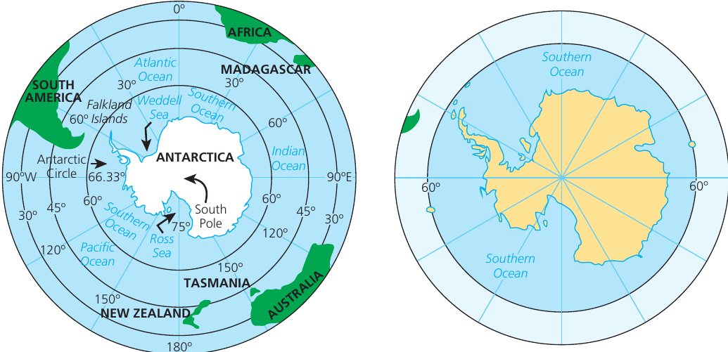
The majority of the Antarctic continent lies south of the Antarctic Circle. However, parts of the East Antarctic coastline and the Antarctic Peninsula extend northwards from West Antarctica to approximately 63°S.
The continent's coastline features extensive ice shelves, which are large floating platforms of ice attached to the land. The two largest ice shelves are:
- The Ross Ice Shelf in the Ross Sea
- The Ronne Ice Shelf in the Weddell Sea
Each of these ice shelves covers an area greater than the size of the British Isles, making them among the largest ice formations on Earth.
The Southern Ocean
In 2000, the International Hydrographic Organization officially designated a fifth world ocean. The Southern Ocean (also called the Antarctic Ocean) comprises the most southern portions of the Atlantic, Indian and Pacific Oceans. It extends from the coast of Antarctica northwards to 60 degrees south latitude, which corresponds with the Antarctic Treaty Limit.
The Southern Ocean represents the most southern waters on Earth, located south of 60°S latitude.
Antarctic Convergence
At approximately 60°S latitude, cold northward flowing waters from the Antarctic region come together with relatively warmer sub-Antarctic waters. This meeting point creates a distinct oceanic boundary.
Antarctic Convergence – A zone continuously encircling Antarctica where cold northward flowing Antarctic waters meet the relatively warmer waters of the sub-Antarctic.
The Antarctic Convergence is a zone approximately 32 to 48 km wide. Its latitude varies seasonally and at different longitudes, extending across the Atlantic, Pacific and Indian Oceans between the 48th and 61st parallels of south latitude.
At this convergence zone, the cold northward flowing Antarctic waters sink beneath the warmer sub-Antarctic waters. This process creates areas of mixing and upwelling currents, which are highly productive in terms of marine life, particularly supporting Antarctic krill (small shrimp-like crustaceans that are a key species in the Antarctic food chain).
Antarctic Convergence Zone
The Antarctic Convergence Zone is a natural boundary that separates:
- Two distinct hydrological regions (different water masses)
- Areas of distinct climate
- Areas of distinctive wildlife
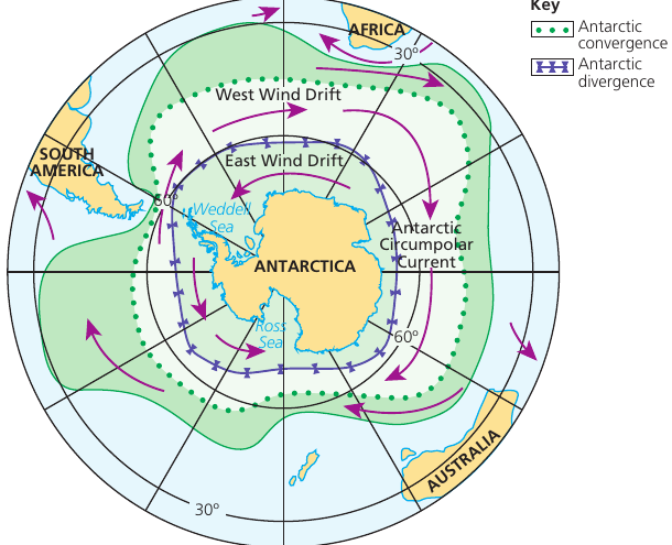
The Convergence Zone occurs at approximately 60 degrees latitude south. This location gives rise to the largest surface current in the world, known as the Antarctic Circumpolar Current, which flows eastward around Antarctica.
Understanding Antarctic Ocean Currents
The Antarctic ocean current system consists of two major currents flowing in opposite directions:
West Wind Drift (Antarctic Circumpolar Current):
- Flows eastward around Antarctica
- Driven by westerly winds
- Blocks warmer waters from travelling southwards
East Wind Drift:
- Flows westward, closer to Antarctica
- Driven by easterly polar winds
- Features prominently in the Ross and Weddell Seas
Where these opposite flowing currents meet, an area known as the Antarctic Divergence is formed.
Physical geography
Antarctica is a distinctive continent characterized by mountains and rocky terrain. Approximately 98% of the continent is covered by thick ice sheets.
The continent is divided into two major regions by the Transantarctic Mountains:
- East (Greater) Antarctica
- West (Lesser) Antarctica
The Transantarctic Mountains contain many peaks exceeding 4,000 m in height. This mountain range also divides the continent's two major ice sheets: the West Antarctic ice sheet and the East Antarctic ice sheet.
The East Antarctic ice sheet is larger in area, thicker, and much older than the West Antarctic ice sheet, making it the more stable of the two ice formations.
The Ellsworth Mountains are located in West Antarctica and contain the continent's highest peak, Mount Vinson, which reaches 4,892 m above sea level.
Elevation and ice thickness
With an average height of 2,500 m above sea level, Antarctica holds the distinction of being the highest continent. This is not due to high mountains alone, but primarily because of the thickness of the ice sheets, which give the continent its exceptional average elevation.
The ice sheets are approximately 2.5 km thick. These massive ice formations are the result of an accumulation of small inputs of snow and frost which far exceed ablation rates (loss through melting and evaporation) over an extremely long period of time.
Unique landscape features
Very little of Antarctica is free from ice. Any ice-free areas that do exist owe their presence to specific local-scale factors.
Nunataks are distinctive features of the Antarctic landscape. These are high mountain peaks where pinnacles of rock emerge above the ice sheets, appearing like islands in a sea of ice. High winds and steep slopes prevent snow and ice from accumulating on these exposed rock formations.
Dry valleys represent another intriguing landscape type found in Antarctica. These are located in high altitude areas and are characterized by extreme aridity (dryness).
Marine ecosystem
The surrounding sea temperatures are warmer than the land, and marine conditions support a diverse and productive ecosystem.
Upwelling of cooler water from the ocean depths brings nutrients to the surface waters. These nutrients support phytoplankton (microscopic algae that form the base of the marine food web). Blooms of phytoplankton provide essential food for krill, which many Antarctic species depend upon as their primary food source.
Antarctic Marine Food Web
The Antarctic marine ecosystem operates through a highly productive nutrient cycle:
- Cooler water upwells from ocean depths, bringing nutrients to the surface
- Nutrients support phytoplankton growth (microscopic algae)
- Phytoplankton blooms provide food for krill populations
- Krill serve as the primary food source for many Antarctic species
This makes the convergence and upwelling zones some of the most biologically productive waters on Earth.
Some coastal areas of Antarctica, particularly along the Peninsula, have a micro-climate and specific topographic conditions. These factors cause sufficient melting during summer months to allow some land areas to remain free of ice. The areas on the western Peninsula are particularly likely to experience more significant climatic differences due to ongoing climate change.
Climate
In addition to being the highest continent, Antarctica is distinctive for having the most extreme climate on Earth. It is simultaneously the coldest, windiest and driest continent.
Temperature
Climatic features of Antarctica include:
- Average temperature of −50°C, though it can drop as low as −89°C
- These extreme temperatures make Antarctica the coldest place on Earth
Wind
- Mean annual wind speed of 50 miles per hour (mph), resulting from convergent katabatic winds (cold, dense air flowing downslope under gravity)
- Gales can reach speeds of 200 mph, making Antarctica the windiest continent
Precipitation
- Mean annual precipitation is low, falling predominantly as snow
- Particularly low in the interior regions at less than 50 mm per annum
- Due to these characteristics, Antarctica can best be described as a polar desert
Antarctica as a Polar Desert
Despite being covered in ice and snow, Antarctica is classified as a polar desert due to its extremely low precipitation levels (less than 50 mm annually). The ice sheets that cover the continent formed over millions of years through the gradual accumulation of small amounts of snow and frost, where inputs exceeded losses from melting and evaporation.
The combination of extreme cold, persistent high winds and minimal precipitation creates one of the harshest environments on Earth. Despite these challenging conditions, the continent supports unique ecosystems, particularly in its coastal and marine environments.
Remember!
Key Points to Remember:
-
Antarctica is almost entirely south of the Antarctic Circle (66.33°S), with the Antarctic Peninsula extending to approximately 63°S being the main exception
-
The Antarctic Convergence is a critical oceanic boundary at approximately 60°S where cold Antarctic waters sink beneath warmer sub-Antarctic waters, creating a highly productive marine zone
-
Antarctica is the highest continent with an average elevation of 2,500 m, primarily due to ice sheets that are approximately 2.5 km thick covering 98% of the land
-
The Antarctic Circumpolar Current (West Wind Drift) is the world's largest surface current, flowing eastward around Antarctica and blocking warmer waters from reaching the continent
-
Antarctica holds three extreme climate records: coldest (average −50°C), windiest (average 50 mph winds, gales to 200 mph), and driest (less than 50 mm annual precipitation), classifying it as a polar desert