Physical Geography (AQA A-Level Geography): Revision Notes
Physical Geography
Understanding water stress
Water stress occurs when there is a mismatch between the amount of water being used and the water resources that are actually available. This shortage creates significant constraints on human activities and development. The level of water stress in a region is measured using specific indicators developed by international organisations.
Water stress is defined as water availability of less than 1,700 m³ per person per year.
Another way to assess water stress is by calculating the proportion of water withdrawal compared to the total water resource available. Regions with higher withdrawal percentages indicate that water users are competing for limited resources.
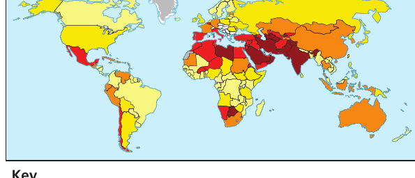
The map above illustrates how water stress varies dramatically across the world. Areas shown in dark red experience extremely high stress (over 80% withdrawal ratio), particularly concentrated in:
- North Africa
- The Middle East
- Central Asia
- Parts of South Asia
Regions in yellow show low stress levels (under 10%), including much of North America, northern South America, and sub-Saharan Africa.
Water stress leads to a deterioration of freshwater supplies in two main ways:
- Quantity issues: Over-extraction from rivers, reservoirs or aquifers reduces available water volumes
- Quality issues: Organic pollution, eutrophication of surface water, or saltwater intrusion into aquifers contaminates water sources
Physical factors affecting water availability
Reliable sources of surface water and aquifers depend on several physical geographic factors. The essential requirements include:
- Dependable annual rainfall: Seasonal variations can occur, but storage facilities help manage temporal differences
- Large surface freshwater bodies: Rivers and lakes provide the most accessible sources for abstraction
- Low evaporation rates: This reduces surface water losses and maintains supply levels
- Suitable geological structures: These formations enable groundwater aquifer development
These four factors work together to determine whether a region can maintain a reliable water supply. Areas lacking even one of these factors may experience water stress, even if other conditions are favorable.
Rivers and lakes as water sources
When deciding whether to abstract water from rivers for human use, several factors about the river's regime must be carefully considered:
- River discharge: The annual flow volume must be sufficient to meet abstraction needs
- Flow variations: Seasonal or temporal changes in flow must be evaluated when determining safe abstraction rates
- Water quality: The level of contamination and turbidity affects treatment requirements before use
- Competing uses: Other river uses such as transport, wildlife conservation, and recreation must be protected
Impacts of over-abstraction
Excessive abstraction from rivers and lakes creates numerous negative environmental consequences:
- Pollutant concentration: Reduced water volume following abstraction concentrates existing pollutants, worsening water quality
- Increased sedimentation: Decreased velocity and discharge increase sedimentation downstream, affecting river channels
- Soil quality degradation: Reduced downstream flooding adversely impacts soil quality in floodplains
- Ecosystem damage: Reduced flow downstream impacts ecosystems and habitats, potentially killing aquatic life
Over-abstraction creates a cascading series of environmental problems. As water volume decreases, pollutants become more concentrated, sedimentation increases, and ecosystems downstream suffer significant damage. The effects extend far beyond the immediate abstraction point.
Reservoirs for water storage
Reservoirs are constructed by flooding valley floors. A dam is built across the river valley, allowing water to accumulate and be stored behind it in a reservoir. Creating reservoirs for water storage and abstraction is controversial for two key reasons:
- Conflict with other valley uses, particularly settlement (requiring population displacement) and food production
- Disruption to the hydrological cycle with impacts on the entire river system
Site selection for reservoirs
Good reservoir sites possess specific physical characteristics that make them suitable for water storage. The table below outlines the preferred conditions:
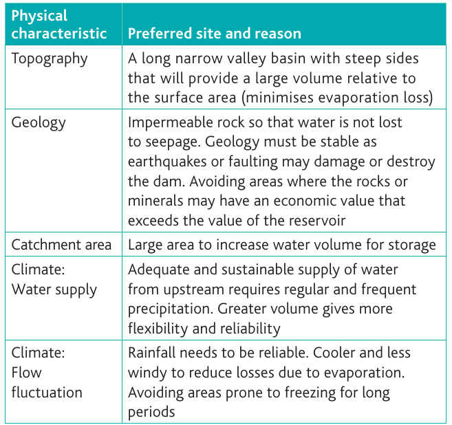
Topography: The ideal site is a long, narrow valley basin with steep sides. This shape provides a large volume of water storage relative to the surface area, which minimises evaporation losses.
Geology: Impermeable rock is essential to prevent water loss through seepage. The geology must also be stable enough to withstand earthquakes or faulting that could damage or destroy the dam. Sites where rocks or minerals have economic value may be avoided to prevent loss of the reservoir investment.
Catchment area: A large catchment area is needed to increase the volume of water that can be stored.
Climate - water supply: Adequate and sustainable precipitation in the upstream area is required. Regular and frequent rainfall provides greater volume, flexibility and reliability for water supply.
Climate - flow fluctuation: Reliable rainfall is essential, with cooler and less windy conditions preferred to reduce evaporation losses. Areas prone to freezing for extended periods should be avoided.
Despite good sites for reservoirs often having the highest value for scenery and wildlife, this creates difficult decisions about where they should be located. The conflict between water supply needs and environmental conservation makes reservoir planning controversial.
Benefits and impacts of reservoirs
Reservoirs provide multiple benefits but also create significant environmental effects:
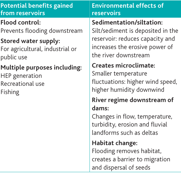
Potential benefits include:
- Flood control: Reservoirs prevent flooding downstream by regulating water release
- Stored water supply: Water can be used for agricultural irrigation, industrial processes, or public consumption
- Multiple purposes: This includes hydroelectric power (HEP) generation, recreational activities such as boating and water sports, and commercial fishing opportunities
Environmental effects include:
- Sedimentation and siltation: Sediment deposited in the reservoir reduces its storage capacity and increases the erosive power of the river downstream
- Microclimate creation: Smaller temperature fluctuations occur near the reservoir, with higher wind speeds and increased humidity
- River regime changes downstream: Flow rates, water temperature, turbidity levels, erosion patterns, and delta formation are all altered
- Habitat changes: Flooding removes existing habitats and creates barriers to fish migration and seed dispersal, fundamentally changing local ecosystems
Aquifers as groundwater sources
Aquifer - A layer of rock that holds groundwater underground.
Aquifers typically form in sedimentary basins where different layers of permeable and impermeable rock create confined and unconfined aquifer systems. For an aquifer to function effectively, the host rock must be impermeable to prevent water escape.
Key aquifer properties
Porosity refers to the proportion of rock which is 'space' and can hold fluids. Porous or permeable rocks such as chalk, limestone, sandstone or gravel are needed to hold a 'reservoir' of underground water.
Permeability describes the rate at which fluids flow through rock because of connected pores or fissures. Permeable rocks enable aquifers to 'recharge' from natural sources where water percolates down through surface layers.
These two properties work together to determine an aquifer's effectiveness. A rock can have high porosity (lots of space to hold water) but low permeability (water can't flow easily), or vice versa. The best aquifers have both high porosity and high permeability.
Aquifer types and structure
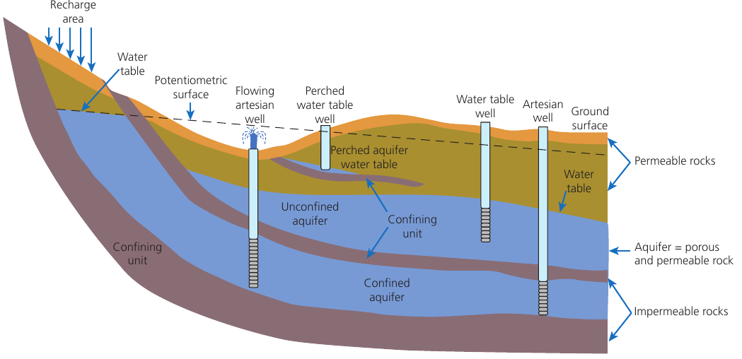
The diagram illustrates two main aquifer types:
Confined aquifers have impermeable layers of rock both above and below them. They are called artesian aquifers and can be recharged where permeable layers meet the surface. If the head of a well is below the natural water table level, water will flow naturally under atmospheric pressure (flowing artesian well). Otherwise, water must be pumped to the surface.
Unconfined aquifers are recharged directly from the surface where permeable layers are exposed. Water from these aquifers is brought to the land surface by wells or springs.
Over-abstraction from aquifers
Groundwater is vulnerable to overuse and improper disposal of chemicals at the land surface. Falling groundwater levels may indicate climate change or prolonged over-abstraction.
Over-abstraction occurs when the rate of water extraction from the aquifer exceeds the recharge rate.
This leads to several serious environmental impacts:
- Subsidence: Ground level sinking as water is removed from underground spaces
- Loss of wetlands: Vegetation changes as wetland areas dry out
- Osmotic dehydration: Drying of soils leading to crop root damage
- Lower water table: Declining groundwater levels
- Rivers drying up: Loss of habitat and recreational opportunities
- Saltwater incursion: Seawater entering groundwater supplies in coastal areas
Aquifers are naturally recharged by rainfall, but this process can take many years as water slowly percolates down to replenish aquifers. The slow recharge rate means that over-abstraction can have long-lasting consequences that persist for decades.
Therefore, aquifers may also be recharged artificially to maintain supply levels.
Strategies to increase water supply
Water supply and demand experience spatial and temporal mismatches. In the UK, for instance, the greatest demand exists in south-east England due to higher population density and greater agricultural needs in arable farming. However, the south-east receives less rainfall and has less surface water than other regions, making it more reliant on groundwater sources. This area has the highest potential water stress of any part of the UK.
Catchment management
Freshwater resources are limited in certain areas and at certain times. Measures can be taken to protect both the quantity and quality of water supplies through integrated management approaches.
The supply of water must be carefully managed. It is used to assess the amount of water available for abstraction licensing, taking into account both human needs and environmental requirements. Environmental Flow Indicators (EFIs) are employed to assess whether river flows are sufficient to support healthy ecology.
Surface water management can best be achieved through storage to even out temporal differences in supply, or by diversion and inter-basin transfers to address spatial inequalities.
UK Approach: Catchment Abstraction Management Strategy (CAMS)
In the UK, the Catchment Abstraction Management Strategy (CAMS) provides an integrated approach to manage the supply of water. This involves:
- Increasing the total amount of water available for use, for example by increasing abstraction levels
- Using water more efficiently, such as by reducing waste in distribution systems
- Making better use of existing supplies by:
- Reducing pollution of existing sources to improve water quality
- Distributing water more effectively to match supply with demand
Storage by reservoir
Reservoirs provide a method of increasing and managing water supply on regional or national scales:
- Dams are built to trap and store surplus winter rainfall or regulate river flow, maintaining habitats and preventing flooding downstream
- Direct supply reservoirs such as Lake Vyrnwy store water for release via pipeline to municipal supplies nearby or further afield
- Reservoirs may fill from rainfall, from natural river flow, or via pumping from nearby rivers
- Large-scale multi-purpose reservoirs such as those created by the Three Gorges Dam on the Yangtze River and Aswan Dam on the River Nile also provide additional benefits including flood control, hydroelectric power generation as well as fishing and tourism opportunities. However, they are not without environmental problems, as shown in the earlier table.
Diversion and inter-basin transfer
River diversion is used to transfer water from one river catchment to another when there is a surplus of water in one area and insufficient supply in another. Water is drawn from rivers, reservoirs and aquifers, then pumped across regions via pipelines and aqueducts. This enables localised droughts to be tackled quickly. Transfer can also occur through river diversion or canal networks.
UK Regional Transfer: Wales to West Midlands
In the UK there is substantial variation in average rainfall between different regions. Snowdonia receives over 400 cm per year, whereas parts of East Anglia receive only 55 cm per year. Demand also varies due to population distribution.
For example, heavy rainfall in sparsely populated mid-Wales is stored in reservoirs and then transported via rivers and pipelines to the densely populated West Midlands conurbation. This demonstrates how inter-basin transfer can address spatial mismatches between water supply and demand.
Remember!
Key Points to Remember:
-
Water stress occurs when availability is less than 1,700 m³ per person per year, creating constraints on human activity, particularly in North Africa, the Middle East and Central Asia.
-
Physical factors affecting water supply include reliable rainfall, large surface water bodies, low evaporation rates, and suitable geological structures for aquifer formation.
-
Reservoirs provide multiple benefits (flood control, water supply, HEP, recreation) but cause environmental impacts including sedimentation, microclimate changes, altered river regimes and habitat loss.
-
Aquifers are underground water stores in permeable rocks; confined aquifers are sandwiched between impermeable layers, while unconfined aquifers recharge directly from the surface.
-
Over-abstraction from aquifers and rivers causes serious environmental problems including subsidence, wetland loss, ecosystem damage, and saltwater incursion in coastal areas.