Changing cities (Edexcel GCSE Geography A): Revision Notes
Mexico City: Context and structure
Introduction to Mexico City as a case study
Mexico City serves as an excellent example for understanding how cities in developing countries are structured and organised. As one of the world's largest urban areas, it demonstrates many characteristics typical of rapidly growing cities in emerging economies. Understanding Mexico City's development helps us learn about urbanisation patterns and challenges facing major cities in the developing world.
Mexico City is particularly valuable as a case study because it combines historical significance with modern urban challenges, making it representative of many developing world cities that have experienced rapid growth and transformation.
Mexico City's geographical context
Site characteristics
Mexico City's site refers to the specific physical location where the settlement was built. The city began as a settlement constructed on an island within Lake Texcoco during the Aztec period, spanning from the 14th to 16th centuries. This original island location provided natural defence and access to water resources, making it an ideal spot for early urban development.
Situation and regional position
The situation of Mexico City describes its broader geographical position and the surrounding features that influence its development. The city is strategically located on the Central Plateau, a flat highland area that is encircled by mountains and volcanic peaks. This elevated position gives Mexico City significant advantages in terms of climate and regional accessibility.
Understanding Site vs Situation:
- Site: The specific type of land used to build a settlement (Mexico City's original island location)
- Situation: The position of a settlement in relation to surrounding physical and human features (Central Plateau surrounded by mountains)
These geographical concepts are essential for understanding why cities develop where they do.
Connectivity and transport links
Mexico City's location makes it a crucial transport hub connecting North and South America. Major highways pass through the city, establishing it as the primary link between the northern and southern parts of the continent. This connectivity has been essential for the city's growth as a commercial and cultural centre. Additionally, Mexico City serves as the national headquarters for theatre, television, and radio broadcasting, reinforcing its role as a communications hub.
Cultural significance
The city holds immense cultural importance as the largest Spanish-speaking urban area in the world. This linguistic and cultural prominence has contributed to its influence across Latin America and has attracted people from across the region seeking opportunities in business, entertainment, and education.
Urban structure of Mexico City
Mexico City's urban structure follows a typical pattern found in many large cities in developing countries, with distinct zones radiating outward from the centre. Each zone has different characteristics in terms of housing quality, economic activities, and social conditions.
Central Business District (CBD)
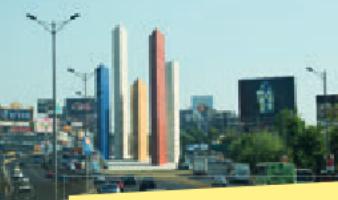
The Central Business District forms the financial and commercial heart of Mexico City. This area is characterised by tall office buildings, including important institutions such as the Mexican Stock Exchange and various government buildings. The CBD has evolved from its historical roots to become a modern business centre that now attracts high-value retail outlets and luxury services. This transformation reflects the city's economic development and its growing importance in international business.
CBD Characteristics in Mexico City:
The Central Business District demonstrates typical features of a major financial hub:
- Financial institutions: Mexican Stock Exchange as the main trading centre
- Government presence: Major government buildings and administrative offices
- Commercial activity: High-value retail outlets and luxury services
- Modern infrastructure: Tall office blocks and contemporary business facilities
This shows how CBDs serve as the main financial hub of major cities.
Inner city areas
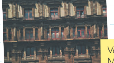
The inner city zones surrounding the CBD are characterised by older, often inadequate housing that was primarily constructed during the 19th century. A distinctive feature of these areas is the presence of 'vecindades' - these are former colonial mansions that have been abandoned by wealthy families and converted into low-cost rental accommodation. Multiple families now occupy these buildings, which were originally designed for single wealthy households. This represents a common pattern in developing cities where historic buildings are repurposed to meet the housing needs of lower-income residents.
Vecindades Explained: Vecindades are abandoned multi-storey colonial mansions that have been converted into cheap tenements and rented out to families. This adaptive reuse of historic buildings is a key feature of inner city areas in many developing world cities, where housing demand far exceeds supply.
Suburban developments
The suburban areas, exemplified by developments like Ciudad Satélite, represent middle-class housing zones. These areas are characterised by planned residential developments with better-quality housing, primarily built to meet the needs of property owners rather than renters. These suburbs often feature improved security measures, including walled-off parking areas, security fencing, and electric barriers with armed guards, reflecting concerns about urban safety and the desire for protected living environments.
Urban-rural fringe
At the outer edges of Mexico City lies the urban-rural fringe, where land use becomes dominated by unregulated, informal settlements known as shanty towns. These areas often lack proper infrastructure and services, representing the challenges faced by rapidly growing cities in accommodating large numbers of migrants seeking urban opportunities.
Common Mistake to Avoid: Don't confuse the urban-rural fringe with suburban areas. The fringe consists of informal settlements with poor infrastructure, while suburbs are planned developments with better facilities. Understanding this distinction is critical for analysis of urban structure.
Housing and development patterns
Mexico City's housing patterns reflect the economic inequalities common in developing world cities. The contrast between the modern CBD, deteriorating inner city housing, planned suburban developments, and informal settlements on the periphery illustrates how different social and economic groups occupy different parts of the urban area. This spatial segregation is a key characteristic of cities experiencing rapid urbanisation without adequate planning or resources to accommodate all residents equally.
Key Points to Remember:
-
Site vs situation: Mexico City's site was originally an island in Lake Texcoco, while its situation on the Central Plateau surrounded by mountains gives it strategic regional importance
-
Connectivity matters: The city's position makes it a vital transport link between North and South America, contributing to its economic and cultural significance
-
Urban structure follows patterns: Like many developing world cities, Mexico City has distinct zones - from the modern CBD through deteriorating inner areas to informal settlements on the fringe
-
Housing reflects inequality: The contrast between vecindades in the inner city, planned suburbs, and informal settlements shows how different income groups occupy different urban spaces
-
Cultural significance: As the world's largest Spanish-speaking city, Mexico City serves as a major cultural and media centre for Latin America