Variety and distribution (Edexcel GCSE Geography A): Revision Notes
Variety and distribution of natural resources
Understanding global resource distribution
Natural resources are spread unevenly across the Earth's surface. This unequal distribution creates significant geographical patterns that you need to understand for your exam. The location of different resources depends on various physical factors, particularly geological processes and climate conditions.
Understanding resource distribution patterns is essential for explaining global economic inequalities, international trade relationships, and geopolitical tensions. Countries with abundant natural resources often have different economic opportunities compared to resource-poor nations.
Global patterns of minerals and fossil fuels
The world's natural resources show clear distribution patterns that relate to the Earth's geological history and structure.
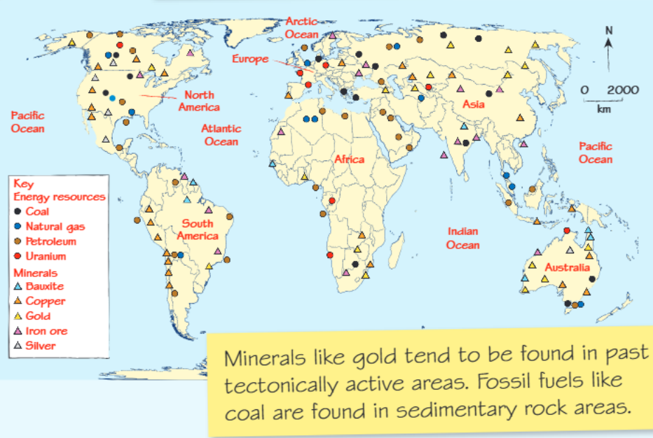
Mineral distribution patterns
Valuable minerals such as gold, silver, copper and iron ore are typically concentrated in specific geological regions. These minerals are predominantly found in areas that experienced significant tectonic activity in the past. When tectonic plates collided or moved apart, the intense heat and pressure created conditions that formed these valuable mineral deposits.
Regional Example: South American Copper
Copper resources are heavily concentrated in South America, particularly along the western coastline where past tectonic activity was intense. South America contains some of the world's largest copper reserves, with significant deposits also found in parts of Africa, North America and Oceania.
Fossil fuel locations
Fossil fuels including coal, natural gas and petroleum follow different distribution patterns compared to minerals. These energy resources are primarily located in sedimentary rock areas, where organic matter was buried and compressed over millions of years.
Key Geological Rule: Minerals like gold tend to be found in past tectonically active areas, while fossil fuels like coal are found in sedimentary rock areas. This fundamental difference in formation processes explains their contrasting global distribution patterns.
Coal deposits are widespread across many continents, particularly in regions with extensive sedimentary rock formations. Oil and natural gas reserves are often found in similar geological settings, frequently occurring together in the same regions.
How latitude affects agriculture and forestry
The distance from the equator significantly influences agricultural productivity and the types of farming that can be practised in different regions.
Latitude Rule: Agricultural productivity generally decreases as you move away from the equator due to changes in temperature, precipitation patterns, and solar radiation intensity.
Equatorial regions
Near the equator, high precipitation levels and intense solar radiation create very productive conditions. These areas support tropical rainforest (TRF) ecosystems and plantation agriculture. The soils, known as latosols, are generally fertile and support diverse agricultural activities.
Polar regions
At higher latitudes towards the poles, conditions become much colder and drier. Productivity levels are low, supporting mainly tundra vegetation and coniferous forests. The soil type changes to podsols, which are often leached and less fertile. These harsh conditions limit agricultural possibilities.
Arid regions
Around 30° North and South of the equator, solar radiation remains high but precipitation becomes very low. These areas typically have little or no vegetation and support nomadic herding practices with irrigated crops in suitable locations. The soils tend to be sandy and desert-like.
The 30° latitude belt is particularly important as it marks the location of many of the world's major deserts, including the Sahara, Arabian, and Australian deserts. This is due to global atmospheric circulation patterns that create high-pressure systems and dry conditions at these latitudes.
The UK's natural resources
Britain has several important natural resource characteristics that shape its economy and land use patterns.
Water resources and precipitation
Precipitation levels are significantly higher in the northern and western parts of the UK compared to the south and east. This creates a contrast between areas with low population density (wet upland areas) and high population density (drier lowland areas in the southeast).
This precipitation pattern is caused by prevailing westerly winds bringing moist air from the Atlantic Ocean, which is forced upward by highland areas in the north and west, causing orographic rainfall.
Agricultural diversity
The types of farming practised across the UK depend on three main factors: soil quality, climate conditions and relief (landscape). East Anglia exemplifies how these factors combine - its flat terrain, fertile soils and warm summer temperatures make it ideal for arable farming, particularly wheat production. In contrast, sheep farming predominates in upland areas like Scotland, where the terrain and climate are less suitable for crop cultivation.
Energy resources
The UK extracts substantial quantities of oil and natural gas from beneath the North Sea. This offshore energy production generates billions of barrels annually, making it a crucial component of the nation's energy security and economy.
UK agricultural distribution patterns
Different regions of the UK specialise in particular types of farming based on their physical geography.
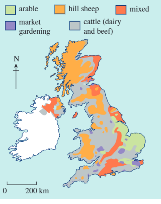
UK Regional Farming Patterns
The agricultural map of the British Isles reveals distinct regional patterns:
- Scotland: Dominated by hill sheep farming, reflecting mountainous terrain and cooler climate
- Central and southern England: More diversity with arable farming in flatter, fertile regions
- Mixed farming zones: Found in transitional areas between upland and lowland regions
- Cattle farming: Concentrated in areas with suitable grasslands for dairy and beef production
- Market gardening: Intensive fruit and vegetable cultivation in areas with optimal growing conditions and good transport links to urban markets
Key Points to Remember:
- Natural resources are distributed unevenly across the globe due to geological and climatic factors
- Minerals like gold are typically found in areas of past tectonic activity, while fossil fuels occur in sedimentary rock regions
- Agricultural productivity and types vary significantly with latitude - equatorial regions are most productive while polar areas have very low productivity
- The UK's resource distribution reflects its physical geography, with higher precipitation in the north and west, and varied agriculture depending on local soil, climate and relief conditions
- Understanding these distribution patterns helps explain global economic inequalities and trade relationships