Physical and human patterns (Edexcel GCSE Geography A): Revision Notes
Physical and human patterns
Understanding physical and human patterns is a crucial geographical skill that you'll use throughout your GCSE studies. This involves learning to describe and explain how natural and man-made features are distributed across different areas using various geographical sources.
What are physical and human patterns?
Physical and human patterns refer to the way geographical features are arranged and distributed across the landscape. Physical patterns involve natural features such as rivers, coastlines, mountains, and valleys. Human patterns focus on man-made features including settlements, roads, buildings, and infrastructure.
Being able to identify and describe these patterns helps geographers understand how environments work and how people interact with their surroundings. This skill appears in all assessment components of your GCSE geography course.
Describing patterns using different sources
You can use three main types of geographical sources to describe and explain patterns: maps, photographs, and sketches. Each source provides different types of information that can help you build a complete picture of an area.
Using maps effectively
Maps are particularly useful for describing the location and distribution of features across an area. When working with maps, you should focus on describing both the physical landscape (such as rivers and coastlines) and human features (like settlements and transport routes).
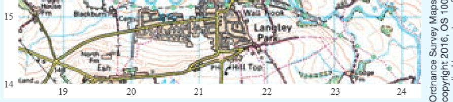
Ordnance Survey maps provide detailed information about both physical and human features. You can use grid references to pinpoint exact locations and describe the relationships between different features. For example, you might notice how settlements are positioned relative to rivers or how roads follow valley floors.
Using photographs and sketches
Photos and sketches can provide additional detail about the function and appearance of settlements and landscapes that maps cannot show. They help you understand what places actually look like and how people use different areas.
Working with map evidence
When describing patterns from maps, you should always use specific map evidence to support your descriptions. This means referring to grid references, place names, and specific features shown on the map.
The technique for describing patterns is similar regardless of what type of pattern you're analysing. You should identify the overall pattern, describe the distribution of features, and use specific evidence from your source to support your observations.
Settlement growth analysis
Understanding how settlements change over time is an important part of studying human patterns. By comparing maps from different time periods, you can identify areas of growth and suggest reasons for these changes.
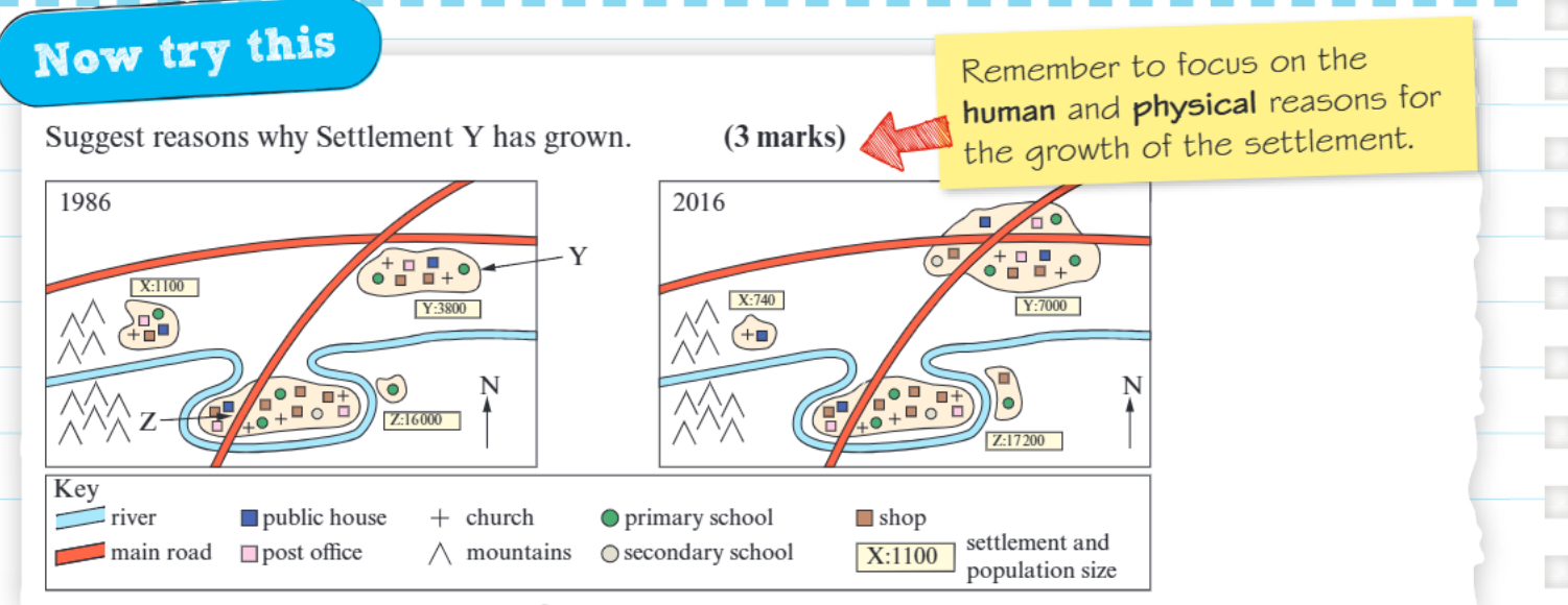
When analysing settlement growth, you need to consider both human and physical factors that influence where people choose to live and work. Human factors might include job opportunities, transport links, and government planning policies. Physical factors could include flat land for building, access to water sources, and protection from flooding.
Settlement patterns often show significant changes over relatively short time periods. Population growth, economic development, and changing transport networks all contribute to the expansion of urban areas into surrounding countryside.
Key techniques for pattern description
Step-by-Step Guide: Describing Geographical Patterns
Step 1: Start with the overall pattern - describe the general arrangement or distribution of features across the area.
Step 2: Use specific evidence - always refer to particular locations, grid references, or named places to support your description.
Step 3: Include measurements where possible - describe distances, elevations, or sizes using specific figures from the map or other sources.
Step 4: Consider relationships - explain how different features relate to each other, such as how settlements are positioned relative to rivers or transport routes.
Step 5: Use appropriate geographical vocabulary - employ terms like "distribution," "clustered," "linear," or "dispersed" to describe patterns accurately.
Key Points to Remember:
- Physical patterns involve natural features like rivers and valleys, while human patterns focus on man-made features such as settlements and roads
- Always use specific map evidence including grid references and place names to support your descriptions
- Maps, photographs, and sketches each provide different types of information for understanding geographical patterns
- When analysing settlement growth, consider both human factors (jobs, transport) and physical factors (flat land, water access)
- Use precise geographical vocabulary and measurements to make your pattern descriptions as accurate as possible