Using and interpreting images (Edexcel GCSE Geography A): Revision Notes
Using and interpreting images
When studying geography, you'll frequently encounter different types of visual evidence that help tell the story of places and processes. Learning to analyse ground-level photographs, aerial images, and satellite imagery is a crucial skill that allows you to gather information about landscapes, human activities, and environmental changes.
Types of geographical images
Understanding the different types of images and their unique characteristics will help you choose the right analytical approach for each one.
Ground-level photographs
Ground-level photographs provide detailed views from a human perspective, showing lots of foreground detail that you can examine closely. When describing these images, focus on using terms like "foreground" and "background" to explain the spatial relationships between different features.
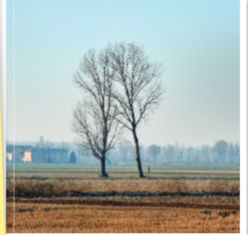
These photographs are excellent for showing local details, textures, and the immediate environment, but they have limited scope in terms of showing the broader landscape context.
Ground-level photographs are particularly valuable for capturing textures, materials, and human-scale details that might be missed in aerial or satellite imagery. However, their narrow field of view means you'll often need to combine them with other image types for complete landscape analysis.
Oblique aerial photographs
Oblique aerial photographs offer a compromise between ground-level detail and broader landscape coverage. They show significantly more area than ground-level photos, making it easier to identify features and understand their relationships to each other.
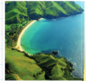
However, judging scale becomes challenging in these images, particularly for features in the background. The perspective can make distant objects appear smaller than they actually are relative to foreground features.
Scale distortion is a critical limitation of oblique aerial photographs. Features in the background may appear much smaller than they actually are, which can lead to incorrect size comparisons and distance estimates. Always be cautious when making measurements or size judgments from these images.
Satellite images
Satellite imagery works by measuring differences in energy radiated by various surfaces on Earth. This technology produces two main types of images. False colour images convert energy data into colours that our eyes can easily recognise and interpret. True colour images show what the satellite actually "sees" - for example, healthy vegetation often appears red in these images.
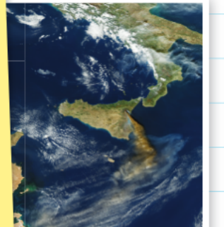
Satellite technology can detect wavelengths of light beyond what human eyes can see, including infrared radiation. This allows scientists to study vegetation health, water quality, soil moisture, and other environmental conditions that wouldn't be visible in regular photographs.
Satellite images are invaluable for studying large-scale patterns, environmental changes over time, and features that might not be visible from ground level or aircraft.
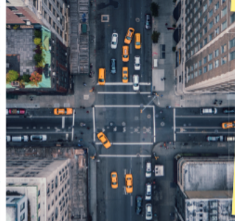
Vertical aerial photographs
Vertical aerial photographs provide a bird's-eye view similar to looking at a map, offering a plan view of the landscape below. While this perspective makes it easy to see spatial relationships and measure distances accurately, fine details can be difficult to identify due to the overhead angle.
The Five Ws approach
When analysing any photograph or image, use the Five Ws framework to ensure you gather comprehensive information:
What does the photo show? Identify the main features, activities, and elements visible in the image.
Why was it taken? Consider the purpose - was it for documentation, research, monitoring, or educational purposes?
Who are the people in it? If people are visible, consider their roles, activities, or relationship to the location.
Where was it taken? Try to identify the location, whether specific or general regional characteristics.
When was it taken? Look for clues about timing - season, time of day, historical period, or stage of development.
Analysing images systematically
When examining any geographical image, take time to study it carefully before jumping to conclusions. The image has been selected for a specific reason, so consider what story it's trying to tell or what evidence it provides.
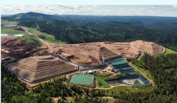
Worked Example: Surface Mining Analysis
When examining this aerial view of surface mining operations, you can systematically identify multiple landscape impacts:
Step 1: Identify major features
- Terraced excavation levels showing the mining process
- Water retention ponds for managing runoff
Step 2: Assess environmental changes
- Complete removal of original forest cover
- Creation of new access roads and infrastructure
Step 3: Consider broader implications
- Scale of landscape modification
- Relationship between mining areas and surrounding environment
Practical application
Different types of aerial photographs serve different analytical purposes. Oblique aerial photographs often provide better context for understanding landscape features compared to vertical shots, as they show both the horizontal and vertical dimensions of terrain and human activities. This makes them particularly useful for studying topics like coastal processes, urban development, or industrial operations.
However, vertical aerial photographs excel when you need to measure distances accurately or compare the spatial relationships between multiple features across a landscape.
Remember!
Key Points to Remember:
-
Master the four image types: Ground-level photos show detail, oblique aerials show context, satellites show large-scale patterns, and vertical aerials show spatial relationships like maps
-
Always use the Five Ws: What, Why, Who, Where, and When provide a systematic framework for thorough image analysis
-
Study images carefully first: Take time to examine all parts of an image before writing - it contains information for a specific purpose
-
Consider scale and perspective: Different image types require different approaches to judging distances, sizes, and spatial relationships
-
Look for evidence of processes: Images often show the results of geographical processes, so think about what might have caused the features you can see