Disaster Preparedness - USA (OCR GCSE Geography B (Geography for Enquiring Minds)): Revision Notes
Be Prepared
Understanding hazard risk mapping
Geographers develop hazard risk maps to identify which areas of a country face the greatest threat from natural disasters. These maps are essential tools for planning and preparing effective disaster response strategies. In the USA, hazard risk maps help authorities understand where resources and preparation efforts should be concentrated.
Why Hazard Risk Mapping Matters
Hazard risk maps allow governments and communities to allocate resources efficiently, ensuring that the areas facing the greatest threats receive appropriate attention and preparation. This targeted approach can save both lives and money when disasters strike.
How hazard risk maps are created
Hazard risk maps are developed by analyzing multiple factors that contribute to the overall level of threat in different regions. Geographers consider three main factors when creating these maps:
- Number of hazard types: How many different types of natural hazard threaten each area. Some regions may face multiple hazards (such as both earthquakes and wildfires), increasing their overall risk level.
- Frequency of occurrence: How often each type of hazard happens in that location. Areas where hazards occur regularly face higher risk than places where they are rare events.
- Potential impact: The likely consequences in terms of deaths and financial damage. This considers both the human cost (lives lost and injuries) and the economic cost (damage to property, infrastructure and businesses).
By combining these three factors, geographers can assign each area a risk level and create a color-coded map showing the overall pattern of risk across the country.
Understanding Risk
Risk is not just about whether a hazard exists in an area. True risk is determined by combining:
- The range of different hazard types present
- How frequently these hazards occur
- The potential impact in lives and economic damage
An area might have only one type of hazard, but if it occurs frequently and causes major damage, the risk level is still very high.
Patterns of hazard risk across the USA
The USA experiences a wide variety of natural hazards, but the pattern of risk is not uniform across the country. Different regions face different types of threats based on their geographical location and environmental characteristics.
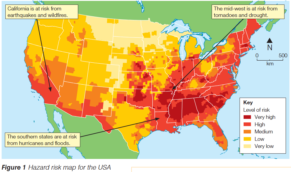
The hazard risk map reveals several important patterns:
California and the West Coast face very high risk levels due to the threat of earthquakes and wildfires. California sits on major fault lines and experiences regular seismic activity. The region's hot, dry climate also creates ideal conditions for destructive wildfires.
The Midwest experiences high to very high risk from tornadoes and drought. This central region of the USA, sometimes called "Tornado Alley," sees frequent severe storms that produce dangerous tornadoes. The area is also vulnerable to periods of extended drought that can devastate agriculture.
The Southern states face very high risk from hurricanes and floods. States along the Gulf Coast and Atlantic seaboard are regularly affected by powerful hurricanes that bring destructive winds, storm surges and torrential rain leading to widespread flooding.
Reading the Risk Map
The map uses a color-coded system to show risk levels, ranging from very low (pale yellow) through low, medium and high, to very high (dark red). The most hazardous parts of the USA are clearly the southern states and the Midwest, which show the darkest red coloring indicating very high risk levels.
Preparing for natural hazards
While we cannot stop natural hazards from happening, we can significantly reduce their impact through effective preparation. Understanding that prevention is impossible but preparation is essential represents a crucial shift in how we approach disaster management.
A Critical Distinction
Natural hazards cannot be prevented from occurring, but their impacts can be significantly reduced through proper preparation. This fundamental principle shapes all disaster management strategies.
There are three main strategies for preparing for natural hazards, often called "the three P's": Prediction, Protection, and Planning.
Prediction
Prediction involves using scientific knowledge and data from previous events to forecast when and where future hazards are likely to occur. By understanding patterns and monitoring warning signs, authorities can issue alerts that give people time to prepare or evacuate.
Prediction in Action: Real-World Examples
Earthquake monitoring: Scientists use networks of seismometers to detect small tremors that might indicate an earthquake is building. While earthquakes cannot be predicted precisely, monitoring helps identify high-risk periods.
Hurricane tracking: Meteorologists use satellite imagery and computer models to track developing storms and predict their path and strength, often providing several days' warning before a hurricane makes landfall.
Drought monitoring: Climate scientists analyze rainfall patterns, temperature data and soil moisture levels to predict drought conditions months in advance.
Protection
Protection strategies involve constructing structures and infrastructure specifically designed to reduce the likelihood of injuries, deaths and damage when a hazard strikes. These physical measures act as barriers between people and the hazard.
Protection Measures in Practice
Flood barriers: Constructing levees, floodwalls and flood gates along rivers and coastlines to prevent water from inundating populated areas during floods or storm surges.
Earthquake-resistant buildings: Designing and constructing buildings with reinforced foundations and flexible frames that can withstand ground shaking without collapsing.
Storm shelters: Building reinforced underground shelters where people can take refuge during tornadoes or severe storms.
Planning
Planning involves developing detailed procedures for how to respond when a hazard occurs, and when possible, how to keep people away from dangerous areas. Effective planning ensures that everyone knows what to do when disaster strikes, reducing chaos and saving lives.
Planning Strategies for Disaster Response
Evacuation plans: Creating clear routes and procedures for evacuating people from threatened areas, including designated assembly points and transportation arrangements.
Emergency response procedures: Training emergency services in disaster response and establishing clear command structures for coordinating rescue and relief efforts.
Land use planning: Restricting development in high-risk areas, such as floodplains or coastal zones vulnerable to storm surges, to keep people out of danger in the first place.
Exam tips
Maximizing Your Exam Performance
When answering questions about disaster preparedness:
-
Always explain that natural hazards cannot be prevented but their impacts can be reduced through preparation.
-
Use the three P's framework (prediction, protection, planning) to structure your answer when asked to explain preparation strategies.
-
Include specific examples to support your points. General statements like "build better buildings" are weak; specific examples like "construct earthquake-resistant buildings with reinforced foundations" are much stronger.
-
When describing hazard patterns, always refer to specific regions rather than vague descriptions. For example, "the southern states face hurricane risk" is better than "some places have storms."
-
Remember that risk depends on three factors: the range (number of different types) of hazards, their frequency, and their potential impacts.
Remember!
Key Points to Remember
-
Hazard risk maps are created using three factors: the number of different hazard types, how frequently they occur, and their potential impact in terms of lives lost and economic cost.
-
Different regions of the USA face different hazards: California experiences earthquakes and wildfires, the Midwest faces tornadoes and drought, and the southern states are threatened by hurricanes and floods.
-
The most hazardous parts of the USA are the southern states and the Midwest, which show very high risk levels on hazard maps.
-
Natural hazards cannot be prevented, but we can prepare for them using the three P's: Prediction (forecasting when and where hazards will occur), Protection (building structures to reduce damage), and Planning (creating procedures for response and evacuation).
-
Effective disaster preparedness requires combining all three strategies to minimize the loss of life and reduce economic damage when natural hazards strike.