Battered Coastline (OCR GCSE Geography B (Geography for Enquiring Minds)): Revision Notes
Battered Coastline
Introduction
The UK coastline faces constant threats from powerful storms and coastal erosion. These natural processes are being intensified by climate change, making certain parts of our coast particularly vulnerable. Understanding these processes and their impacts helps us prepare for and manage coastal hazards.
Coastal hazards are becoming increasingly severe as climate change amplifies natural processes. The combination of rising sea levels, more intense storms, and increased rainfall creates a perfect storm of conditions that threaten both natural landscapes and human communities along our coasts.
The 2014 storm: A case study of the Jurassic Coast
On 5 February 2014, an extremely powerful storm battered the Jurassic Coast of Devon and Dorset. This storm caused widespread and severe damage along multiple sections of the coastline, demonstrating the destructive power of extreme weather events.
Case Study: The 2014 Jurassic Coast Storm
This storm provides a clear example of how extreme weather events can devastate coastal areas:
Infrastructure damage:
- The main railway line at Dawlish was undermined and destroyed by powerful waves
- The critical Exeter to Plymouth transport link closed for two months
- Severe disruption affected travel and local communities
Coastal flooding:
- Portland Bill experienced severe flooding at the end of Chesil Beach
- Floodwater overwhelmed the area and damaged several buildings
- Coastal settlements proved vulnerable to extreme weather
Natural landform changes:
- West Bay coastal cliffs collapsed from intense wave battering and rainfall
- The coastline retreated by several metres as large cliff sections fell
- Rock falls demonstrated the dynamic nature of coastal processes
Defence testing:
- Lyme Regis coastal defences withstood powerful wave assault
- Defences protected the town from major damage despite significant force
- The storm tested the resilience of coastal protection infrastructure
How climate change intensifies coastal impacts
Climate change acts as a threat multiplier for coastal areas, making storm impacts more severe and increasing the frequency of damaging events. Several interconnected processes explain this worsening situation.
Climate Change as a Coastal Threat Multiplier
Climate change doesn't create entirely new coastal hazards, but it significantly amplifies existing ones. Think of it as turning up the volume on natural processes that have always affected our coasts. This means areas that experienced occasional problems may now face frequent crises, while previously safe areas may become vulnerable.
Rising sea levels
Warming global temperatures directly contribute to higher sea levels through two main mechanisms. As temperatures rise, ice sheets and glaciers melt, adding more water to the oceans. At the same time, seawater expands as it warms, taking up more space. These higher sea levels mean that storm waves can reach further inland and attack coastal areas that were previously safe.
More intense storms
A warmer atmosphere holds more moisture and energy, which leads to the formation of more intense and powerful storms. These extreme weather events generate larger, more destructive waves that can cause significantly more damage to both natural coastlines and human structures. The increased wave energy accelerates coastal erosion and makes storm impacts more severe.
The relationship between atmospheric temperature and storm intensity is exponential. Even small increases in global temperature can result in disproportionately larger and more frequent extreme weather events. This is why a seemingly modest 1-2°C rise in global temperatures can have such dramatic coastal impacts.
Increased weathering
Climate change brings more intense rainfall to many regions, including the UK. This additional rainfall leads to greater weathering of coastal cliffs, as water penetrates cracks in the rock and breaks it down more rapidly. The saturated cliffs become unstable, causing rock falls and landslides to occur more frequently. This process weakens cliff faces and makes them more vulnerable to wave attack.
Vulnerability of the UK coastline
Climate change impacts the entire UK coastline, but the severity of effects varies considerably depending on local geology and geography. Understanding these variations helps identify which areas need the most protection.
Coastal Vulnerability Factors
Not all UK coastlines are equally vulnerable to erosion and flooding. Two key factors determine risk levels:
- Soft rock coasts: Areas with cliffs made of clay, sandstone, or other easily eroded materials experience rapid retreat
- Low-lying land: Flat coastal areas face severe flooding risks even from modest sea level rises
These vulnerable areas require urgent attention in coastal management planning.
Areas at greatest risk
The impact of climate change and coastal erosion is greatest along two types of coastline. Areas where cliffs consist of softer rocks experience faster erosion because the rock is more easily worn away by wave action. Low-lying coastal land faces severe flooding risks because even modest rises in sea level can inundate large areas.
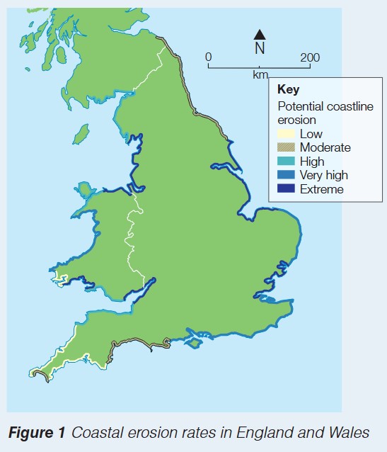
The map above shows the variation in coastal erosion potential around England and Wales. The color coding reveals that certain stretches of coastline face extreme erosion risk (shown in dark blue), while other areas experience only low to moderate risk. The east coast and parts of the south coast show particularly high vulnerability due to their geology and low-lying nature.
Why vulnerability varies
Coastal geology plays a crucial role in determining erosion rates. Hard rock coastlines, such as those made of granite or limestone, resist erosion more effectively than soft rock coasts composed of clay or sandstone. The shape of the coastline also matters, with headlands experiencing more concentrated wave attack than sheltered bays.
The concept of differential erosion explains why the UK coastline has such varied shapes and features. Hard rocks form bold headlands and cliffs that project into the sea, while soft rocks are worn back to form bays and beaches. This natural variation in erosion rates creates the distinctive coastal landscapes we see today.
Climate change will continue to affect these vulnerable areas, potentially making the differences between high-risk and low-risk coasts even more pronounced as sea levels rise and storms intensify.
Key Points to Remember:
-
The 5 February 2014 storm caused severe damage along the Jurassic Coast, including railway destruction at Dawlish, flooding at Portland Bill, cliff collapse at West Bay, and wave attack at Lyme Regis
-
Climate change intensifies coastal impacts through three main processes: rising sea levels from warming temperatures and melting ice, more powerful storms creating larger waves, and increased rainfall causing greater weathering and landslides
-
The UK coastline experiences varying levels of erosion risk, with soft rock coasts and low-lying areas facing the greatest threats from climate change and storm impacts
-
Understanding coastal vulnerability patterns helps planners identify which areas need protection and manage coastal development appropriately
-
Remember the pattern: "Soft and Low = High Risk" - soft rocks and low-lying land experience the most severe erosion and flooding