Coastal Landforms (OCR GCSE Geography B (Geography for Enquiring Minds)): Revision Notes
Coastal landforms
Introduction
The UK's coastline is continuously shaped by the powerful action of waves. The type of coastal landforms that develop in any location depends largely on the underlying geology – specifically, the type and hardness of rock present. Understanding how geology interacts with wave processes is essential for explaining the diverse coastal landscapes found around the UK.
The influence of geology on coastal shape
Geology plays a fundamental role in determining which landforms develop along a coastline. Different rock types have varying levels of resistance to erosion, which directly affects how quickly they wear away under the constant action of waves.
Headlands develop in areas where hard, resistant rock types (such as granite) are present. These rocks withstand wave erosion much more effectively, meaning they erode very slowly over time. As a result, these areas protrude out into the sea, forming prominent coastal features.
Bays occur in sections where softer, less resistant rock (such as clay) is exposed to wave action. These rock types are much more vulnerable to erosion and wear away relatively quickly. The faster erosion of these areas creates curved indentations in the coastline between the more resistant headlands.
This variation in rock resistance creates the characteristic irregular coastline pattern of alternating headlands and bays that is common around the UK coast. This pattern demonstrates the direct relationship between rock type and coastal shape.
Erosional coastal landforms
Headlands do not remain unchanged – they undergo progressive erosion over time. As waves continuously attack a headland, they create a sequence of distinctive landforms. Each stage in this erosional sequence produces a recognizable feature.
The Erosional Sequence: CAS
Remember the order: Cave → Arch → Stack
Each feature develops from the previous one in this specific sequence, representing progressive stages of headland erosion.
Caves
The erosion process begins at the base of the cliff face. Waves concentrate their energy on any weak points in the rock, such as cracks or joints. Through repeated hydraulic action and abrasion, these weak areas are gradually worn away. Eventually, this erosion creates a hollow opening in the cliff base – a cave. Caves typically form where there are zones of weakness in the rock that waves can exploit more easily.
Arches
As erosion continues, caves on opposite sides of a narrow headland may gradually extend deeper into the rock. When two caves meet, or when a single cave erodes completely through the headland from one side to the other, an arch forms. This creates a distinctive natural bridge of rock spanning a gap, with the sea flowing through the opening beneath. Arches represent an intermediate stage in the erosional sequence and are often spectacular coastal features.
Stacks
The arch structure is inherently unstable. Wave action continues to erode the base of the arch, while weathering attacks the top. Eventually, the roof of the arch becomes too weak to support its own weight and collapses. When this happens, the section of rock that was previously connected to the headland becomes isolated. This leaves behind a stack – a tall pillar of rock standing alone in the sea, separated from the mainland. Stacks will themselves continue to erode until they are eventually worn down to small stumps.
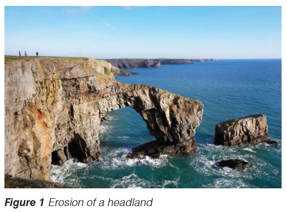
The image above shows these erosional features in action, with a natural arch formation carved through a headland, demonstrating the power of marine erosion on coastal geology.
Coastal transport processes
Wave action does not only erode material – it also moves and deposits sediment along the coast. Understanding these transport processes is crucial for explaining depositional landforms.
Swash and backwash
When a wave breaks on a beach, the water rushes up the slope of the beach, carrying sediment with it. This upward movement is called swash. The water then flows back down the beach under gravity, again transporting material. This downward movement is called backwash. Together, swash and backwash create a continual cycle of sediment movement on the beach.
"Swash up, back down"
An easy way to remember: swash carries material up the beach, while backwash carries it back down. This continuous cycle moves sediment on and off the beach with each wave.
Longshore drift
Longshore drift is a crucial transport process that moves material along the coast. It occurs because waves rarely approach the shore at a perfect right angle. Instead, they usually approach at an angle determined by the prevailing wind direction.
When waves break at an angle, the swash carries sediment up the beach at that same angle. However, the backwash flows straight back down the beach under gravity, at a right angle to the shore. This creates a zigzag movement pattern for sediment particles. Over time, with repeated wave action, sediment is gradually transported along the beach in the direction of the prevailing wind and waves. This process can move material considerable distances along the coastline.
Depositional coastal landforms
As waves transport eroded material, they eventually deposit it in other locations, creating distinctive coastal features.
Beaches
A beach is formed where waves deposit material. Beaches consist of sediment of various sizes, from fine sand to larger pebbles and shingle. The material that forms beaches originally comes from the erosion of cliffs and headlands.
Waves transport this sediment and deposit it in areas where their energy decreases. Beaches typically form in bays and other sheltered areas where wave energy is lower, allowing deposition to occur rather than continued erosion.
Spits
A spit is an elongated beach feature that extends across a bay or river mouth. Spits form through longshore drift. As sediment is transported along the coast by this process, it continues to be deposited even where the coastline changes direction, such as at a bay or estuary.
The sediment builds up progressively, creating a long, narrow beach that projects out from the coast. Spits often have a curved end where wave refraction and secondary winds cause the deposited material to bend back toward the land. Behind spits, sheltered areas of calm water often develop, which may fill with mud and silt to form salt marshes.
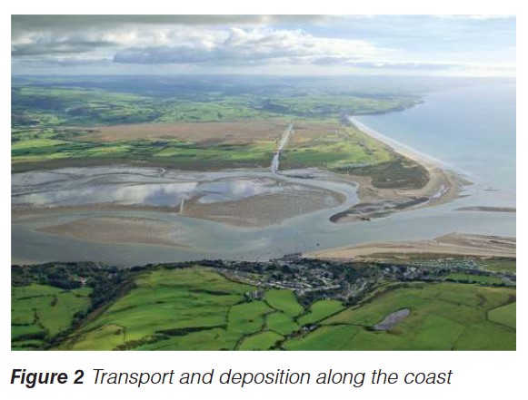
Spits demonstrate the power of longshore drift to transport and deposit material over long distances. The characteristic curved end of a spit is a key identifying feature that results from wave refraction in deeper water.
Key Points to Remember:
-
Geology controls coastal landforms – resistant rocks form headlands while softer rocks erode to create bays
-
Erosional sequence – waves erode headlands progressively to form caves, then arches, then stacks as each feature develops from the previous one
-
Wave transport – swash moves material up the beach while backwash carries it back down
-
Longshore drift – sediment moves along the coast in a zigzag pattern due to waves approaching at an angle, transporting material considerable distances
-
Deposition creates beaches and spits – sediment is deposited where wave energy decreases, building up beaches in bays and extending spits across bay mouths