Flooding on the Thames (OCR GCSE Geography B (Geography for Enquiring Minds)): Revision Notes
Flooding on the Thames
Introduction to the 2014 floods
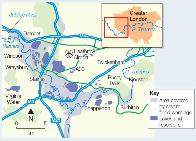
In February 2014, the River Thames experienced its most severe flooding in 40 years. The worst-affected areas were located west of London, particularly the villages of Wraysbury and Staines. This flooding event provides an important case study for understanding flood risk in the UK and the measures taken to manage such disasters.
The floods occurred following an exceptionally wet winter period in 2013/14. By 9 February, water levels in the Thames had risen dangerously high, prompting the Environment Agency (EA) to issue flood warnings. Communities along the river faced significant disruption as properties and infrastructure were damaged by floodwater.
This case study is particularly valuable for understanding how both natural and human factors combine to create flood risk, and how effective emergency management can prevent loss of life even during severe flooding events.

Causes of the 2014 Thames floods
Understanding why flooding occurred requires examining both physical and human factors that contributed to the event.
Physical causes
The primary physical cause was excessive rainfall during the winter of 2013/14. The region received more than double the normal winter rainfall, which overwhelmed the river system's capacity. This prolonged period of heavy precipitation meant that soils became completely saturated, unable to absorb any additional water.
When ground becomes saturated, rainfall cannot infiltrate into the soil. Instead, water runs off the surface directly into rivers and streams, causing water levels to rise rapidly. This saturation effect was a critical factor in the 2014 floods.
The combination of prolonged rainfall and saturated ground created conditions where any additional precipitation immediately contributed to surface runoff and river flow, rather than being absorbed into the soil.
Human causes
Human activities also played a significant role in increasing flood risk in the Thames catchment area.
Urban development has altered natural drainage patterns in the Thames catchment. Buildings, roads, and other impermeable surfaces prevent rainwater from soaking into the ground. Instead, water flows quickly across these surfaces into drainage systems and rivers, causing faster and higher peak flows.
The Jubilee River, an artificial flood relief channel, was designed to divert water around Maidenhead and reduce flood risk in some areas. However, this channel also speeds up the flow of water downstream, which can increase flood risk in other locations such as Wraysbury and Staines.
This demonstrates how flood management in one area can have unintended consequences elsewhere. Engineers must carefully consider the entire river system when designing flood defences, as solutions in one location may simply transfer the problem to communities downstream.
Exam tip: When explaining causes of flooding, always distinguish between physical factors (weather and natural processes) and human factors (land use changes and engineering). Use specific evidence from the case study to support your points.
Impacts of the floods
The 2014 Thames floods had substantial effects on communities and the economy, though effective emergency planning helped prevent loss of life.
Social impacts
Over 5,000 homes and businesses were flooded in Wraysbury and Staines, forcing residents to evacuate their properties. Many people were unable to return to their homes for several months while repairs were carried out. The flooding caused not only property damage but also significant emotional distress and disruption to daily life for affected residents.
Positively, no lives were lost during the floods, demonstrating the effectiveness of the warning systems and emergency response procedures in place.
Economic impacts
The economic consequences were severe. Homes suffered water damage requiring extensive repairs and replacements of furnishings and fittings. Businesses faced closure during the flood period, resulting in lost income and economic disruption.
The total cost of cleaning up after the floods exceeded \£50 million. This figure includes repairs to damaged properties, compensation payments, and the costs of emergency services and recovery operations.
The economic impact of flooding extends beyond immediate damage costs. Businesses lose revenue during closures, property values may decline in flood-affected areas, and insurance premiums typically increase for residents. The \£50 million cleanup cost represents just the direct costs and does not include these wider economic effects.
Exam tip: When describing impacts, organize them into categories (social, economic, environmental) and include specific figures to demonstrate the scale of the disaster. The fact that no lives were lost is also an important impact to mention as it shows successful management.
Responses to the floods
Authorities and communities implemented both immediate and longer-term responses to manage the crisis and reduce future flood risk.
Short-term responses
The Environment Agency took swift action by issuing 14 flood alerts along the Thames. These warnings gave residents advance notice of the flood risk, allowing them time to prepare and protect their properties.
Emergency services evacuated people from their homes when flooding became severe. This rapid response helped ensure public safety and contributed to the zero fatality rate.
Early warning systems are crucial for protecting lives during floods. The success of the 2014 response shows that timely flood alerts, combined with effective evacuation procedures, can prevent deaths even during severe flooding events.
Long-term responses
Learning from the 2014 event, authorities developed plans for a new flood relief channel on the Thames. This infrastructure project aims to reduce flood risk west of London by providing additional capacity to manage high water flows.
Flood relief channels work by diverting excess water away from populated areas during periods of high flow. However, planners must carefully consider how such channels affect flood risk both upstream and downstream to avoid simply transferring the problem to other communities.
Exam tip: For full marks on questions about responses, explain both immediate actions (warnings, evacuations) and longer-term strategies (infrastructure, planning). Show understanding that managing flood risk in one location can affect other areas.
Summary of causes, impacts and responses
| Causes | Impacts | Responses |
|---|---|---|
| Winter rainfall exceeded normal levels by more than double during 2013/14 | Over 5,000 homes and businesses were flooded in Wraysbury and Staines | The Environment Agency issued 14 flood alerts along the Thames |
| Soil had absorbed the maximum amount of water it could hold | Some homes sustained damage and residents could not return for several months | Emergency services evacuated people from their homes |
| Urban surfaces such as buildings and roads increase the speed of water flow to rivers | The cleanup operation cost more than \£50 million | Plans were developed for a new flood relief channel on the Thames to reduce flood risk west of London |
| A new artificial channel on the Thames (the Jubilee River) accelerates water flow, increasing flood risk in Wraysbury and Staines | No deaths occurred |
Remember!
Key points to remember:
- The February 2014 floods were the worst Thames flooding in 40 years, severely affecting Wraysbury and Staines west of London
- Physical causes included excessive rainfall (over twice normal winter levels) and saturated ground, while human causes included urban development and the Jubilee River artificial channel
- Over 5,000 properties flooded with cleanup costs exceeding \£50 million, but effective warnings and evacuations meant no lives were lost
- The Environment Agency issued 14 flood alerts and emergency evacuations took place, with plans developed for new flood relief infrastructure
- Flood management strategies like relief channels can reduce risk in some areas but potentially increase it elsewhere
Key terms:
- Flood risk: The likelihood and potential consequences of flooding in a particular area
- Saturated ground: Soil that has absorbed the maximum amount of water and cannot absorb any more
- Flood relief channel: An artificial waterway designed to divert excess water away from flood-prone areas
- Environment Agency (EA): The UK government organization responsible for flood warnings and environmental protection
Critical frameworks:
- CIR Framework for flood events: Always structure flood case studies using Causes (physical and human), Impacts (social, economic, environmental), and Responses (short-term and long-term)
- Use specific evidence and figures to support points in exam answers
- Consider how flood management in one location affects flood risk elsewhere in the river system