Human Activity and Landscape (OCR GCSE Geography B (Geography for Enquiring Minds)): Revision Notes
Human Activity and Landscape
How human activities shape the landscape
The UK's landscapes have been significantly modified by human activity over thousands of years. While many people live in urban areas such as towns and cities, even rural landscapes that appear completely natural have been shaped by human intervention.
The transformation of Britain's woodland cover represents one of the most dramatic landscape changes in our history. This process occurred over centuries and has fundamentally altered the character of the British landscape.
The most dramatic historical change involved woodland. Centuries ago, natural woodland covered large parts of the UK. However, most of this original deciduous forest was cleared hundreds of years ago for agriculture, settlement and timber. In the last century, replanting programmes have restored some woodland cover, though much of this consists of coniferous plantations rather than natural deciduous forest.
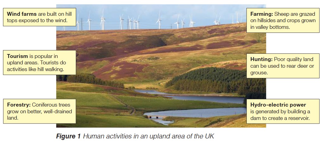
Human activities in upland areas
Upland regions demonstrate a crucial geographical principle: physical geography directly influences human land use patterns. The altitude, terrain, climate and soil conditions of upland areas determine which activities are viable and sustainable.
Upland regions of the UK support several distinctive activities:
Wind farms are strategically located on hilltops and exposed ridges. These elevated positions provide consistent strong winds needed for efficient electricity generation. The turbines have become a distinctive feature of upland skylines.
Farming in upland areas differs from lowland agriculture. Sheep grazing dominates hillsides because these animals can survive on rough grassland in harsh conditions. Valley bottoms, where soils are deeper and more fertile, are used for growing crops.
Tourism thrives in upland regions due to their scenic beauty and recreational opportunities. Visitors participate in activities such as hill walking, enjoying the dramatic landscapes and relative remoteness these areas offer.
Forestry in upland areas takes advantage of natural drainage patterns. Sloping terrain prevents waterlogging, creating better growing conditions for trees than flat, poorly-drained lowland sites.
Forestry takes advantage of upland terrain where soil drainage is better on sloping land. Coniferous trees, particularly species like spruce and pine, grow well in these conditions and provide commercial timber.
Hunting utilizes poor-quality upland areas unsuitable for intensive farming. Moorland and rough grassland support game birds such as grouse and deer, which are managed for sporting purposes.
Hydro-electric power generation exploits upland geography by constructing dams across valleys. These create reservoirs that store water at high altitude. When released, the water flows downhill through turbines, converting gravitational potential energy into electricity.
Land use patterns in upland and lowland areas
England and Scotland show contrasting land use patterns because their physical geography differs significantly. England is predominantly lowland, while Scotland is mainly upland. This fundamental difference creates distinctive landscapes in each country.
The distribution of land use types reflects these geographical differences:
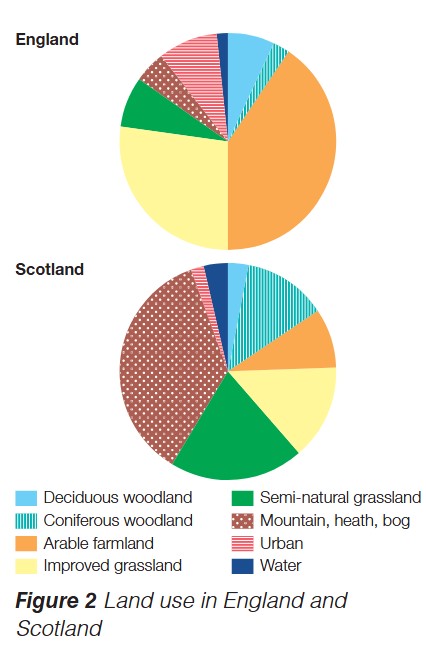
Deciduous woodland coverage illustrates these contrasts, with England retaining 7% coverage compared to Scotland's 3%.
Arable farmland (crop growing) is concentrated in England's lowland areas where flat terrain, deeper soils and milder climate create ideal conditions. This land use forms a much smaller proportion of Scotland's landscape.
Improved grassland for intensive livestock farming is more extensive in English lowlands, whereas Scotland's upland terrain limits this type of agriculture.
The distinction between different woodland types reflects both climate preferences and land management decisions. Coniferous species are more tolerant of upland conditions and grow faster, making them economically attractive for commercial forestry operations.
Coniferous woodland plantations are more common in Scottish uplands, where commercial forestry takes advantage of areas unsuitable for farming.
Semi-natural grassland, mountain, heath and bog habitats are predominantly found in Scotland's upland regions. These ecosystems occur where altitude, exposure and poor drainage make other land uses impractical.
Urban land use is present in both countries but represents a relatively small percentage of total land area in each case.
Key Points to Remember:
- Human activity has modified virtually all UK landscapes, even those appearing natural.
- Historical deforestation removed most original woodland; replanting in recent centuries has partially restored tree cover.
- Upland areas support distinctive activities including wind farms, sheep farming, tourism, forestry, hunting and hydro-electric power generation.
- England (mainly lowland) and Scotland (mainly upland) show different land use patterns reflecting their contrasting physical geography.
- Land use choices depend on physical factors such as altitude, slope, soil quality, drainage and climate.