Landforms Along the Thames (OCR GCSE Geography B (Geography for Enquiring Minds)): Revision Notes
Landforms Along the Thames
The River Thames provides excellent examples of landforms created by river processes. Understanding how the river's characteristics influence landform development is essential for examining distinctive landscapes in the UK.
The Thames serves as an ideal case study for examining lowland river processes and landforms. Its well-documented features and accessible location make it particularly valuable for understanding river geomorphology.
Characteristics of the Thames
The Thames is classified as a lowland river, meaning it flows through relatively flat terrain at low elevation. A key characteristic is its gentle gradient, which significantly influences the type of erosion that occurs.
With a low gradient, the river has less gravitational energy for cutting downwards. Instead, erosion occurs predominantly from side to side across the valley floor, known as lateral erosion.
Understanding the gradient-erosion relationship:
The Thames' gentle gradient is crucial to understanding its landforms. Low gradient = less energy for downward erosion = dominance of lateral (sideways) erosion. This fundamental relationship explains why the Thames develops meanders rather than cutting a deep, narrow valley.
This sideways erosion is the primary process responsible for creating the distinctive meander pattern seen along much of the Thames' course.
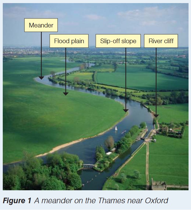
Meanders on the Thames
As the Thames flows across its valley, lateral erosion causes the river to develop pronounced bends called meanders. These meanders are not uniform; they create different landforms depending on the water's speed and behaviour around each bend.
Features of meanders
Outside of the bend:
The water flows fastest on the outer edge of a meander bend. This faster-flowing water has greater erosive power and attacks the riverbank, undercutting it through hydraulic action and abrasion. Over time, this creates a steep bank called a river cliff.
Inside of the bend:
On the inner edge of the bend, water flows more slowly due to increased friction with the riverbed and banks. This slower water lacks the energy to carry its load (the sediment it's transporting). Consequently, material is deposited on the inside of the bend, gradually building up to form a gently sloping feature called a slip-off slope.
Meander Memory Aid: "CLIFF Outside, SLIP Inside"
- Cliff on the Outside = Fast water erodes
- Slip-off slope on the Inside = Slow water deposits
This simple rule helps you remember which feature forms where and why!
These contrasting features—steep river cliffs and gentle slip-off slopes—are characteristic of meandering rivers and can be clearly observed along the Thames, particularly near Oxford.
Common mistake to avoid:
Don't confuse which feature forms where! River cliffs form on the outside of bends (where water is fast), while slip-off slopes form on the inside of bends (where water is slow). The speed of water determines whether erosion or deposition occurs.
Rejuvenation on the Thames
The Thames has not always flowed at its current level. Throughout geological time, particularly during and between ice ages, significant changes in sea level have profoundly affected the river's behaviour. This process is called rejuvenation, where a river gains renewed energy to erode.
Impact of sea level changes
Sea level has fluctuated dramatically over thousands of years, particularly during the Quaternary ice ages. These changes altered the Thames' gradient and, consequently, its erosive power.
When sea level fell (during ice ages):
As sea level dropped, the Thames' gradient became steeper. This increased slope gave the river more energy and erosive power. Rather than flowing from side to side, the rejuvenated river began cutting vertically downwards into its existing floodplain. This downward erosion left the old floodplain elevated above the new river level.
Memory aid: "Fall → Fast → Down" - Sea level falls → steeper gradient → downward erosion
When sea level rose (inter-glacial periods):
As ice melted and sea levels rose again, the river's gradient decreased. The Thames lost energy and could no longer maintain its downward erosion. Instead, it began depositing the material it was carrying, creating a new, lower floodplain.
Memory aid: "Rise → Relaxed → Deposit" - Sea level rises → gentler gradient → deposition
Formation of river terraces
The elevated remnants of old floodplains, left high above the current river level, are called river terraces. These stepped features can be seen at various heights along the Thames valley and provide evidence of past changes in river behaviour.
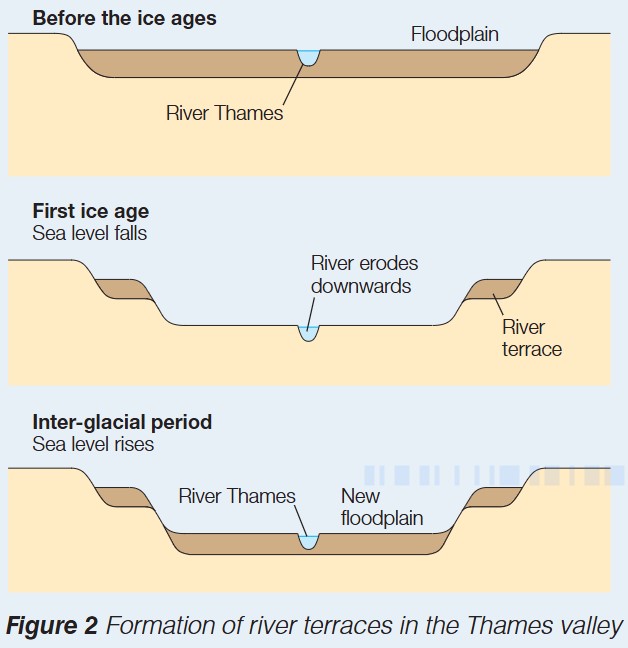
Formation Process: Three-Stage Development of River Terraces
The diagram above shows three stages in the formation of river terraces:
Stage 1 - Before the ice ages: The Thames flowed across a floodplain in a relatively shallow valley
Stage 2 - First ice age (sea level falls): With a steeper gradient, the river eroded downwards, abandoning its original floodplain which became elevated as a river terrace
Stage 3 - Inter-glacial period (sea level rises): The gradient reduced, downward erosion ceased, and the river deposited material to create a new, lower floodplain
Multiple ice ages have created several terraces at different heights, each representing a former river level.
These terraces are important landscape features in the Thames valley and provide valuable evidence for understanding past environmental changes.
Exam Guidance
Exam Success Strategies:
When describing landforms along the Thames:
- Describe: State what features look like (e.g., "River cliffs are steep banks on the outside of meander bends")
- Explain: Link processes to features (e.g., "Fast-flowing water on the outside of bends erodes the bank, creating river cliffs")
- Link to gradient: Always connect landform development to the Thames' gentle gradient and resulting lateral erosion
When discussing rejuvenation:
- Be specific about the direction of sea level change and its effects
- Link sea level change → gradient change → erosion/deposition → landform creation
- Remember that river terraces are evidence of past river levels
Remember!
Key Points to Remember:
-
The Thames is a lowland river with a gentle gradient, resulting in more lateral erosion than downward erosion, which creates distinctive meanders
-
Meander features include river cliffs (steep banks on the outside of bends formed by fast-flowing water) and slip-off slopes (gentle deposits on the inside of bends formed by slow-flowing water)
-
Past sea level changes have rejuvenated the Thames, particularly during ice ages when falling sea levels increased the river's gradient and erosive power
-
River terraces are elevated former floodplains created when falling sea levels caused the Thames to erode downwards, abandoning its old floodplain
-
When sea levels rose again during inter-glacial periods, the river's gradient decreased, causing deposition and the formation of a new, lower floodplain