Landscape Fieldwork (OCR GCSE Geography B (Geography for Enquiring Minds)): Revision Notes
Landscape Fieldwork
Introduction
Fieldwork is a crucial component of geographical investigation that allows you to collect primary data in real environments. This topic covers how to plan and conduct fieldwork investigations in both coastal and river landscapes. You will learn about the stages of planning, the methods available for data collection, and the safety considerations that must be taken into account before any fieldwork takes place.
Fieldwork provides direct, hands-on experience of geographical processes and landscapes, making abstract concepts tangible and enhancing understanding through real-world observation and data collection.
Planning a coastal fieldwork investigation
Stages of fieldwork investigations
All fieldwork investigations, whether conducted at coastal or inland locations, should follow a structured approach consisting of six key stages:
Stage 1: Develop a question or hypothesis Begin by formulating a clear enquiry question or developing a testable hypothesis. This provides focus and direction for your investigation. Your question should be specific, measurable, and answerable through fieldwork data collection.
Stage 2: Select appropriate fieldwork methods Choose the most suitable data collection techniques that will help you answer your question effectively. The methods you select should be practical, safe, and appropriate for your location and resources.
Stage 3: Process and present data Once data has been collected, it needs to be organized and displayed clearly. This typically involves creating maps, graphs, diagrams, and other visual representations that make patterns and relationships easier to identify.
Stage 4: Analyse and explain data Examine the data you have collected carefully, looking for patterns, trends, and anomalies. Use your geographical knowledge to explain what the data shows and why these patterns might exist.
Stage 5: Draw conclusions Use evidence from your data analysis to answer your original question. Your conclusions should be directly linked to the evidence you have gathered and should address your initial hypothesis or question clearly.
Stage 6: Reflect and evaluate Consider the entire investigation process critically. Evaluate the strengths and limitations of your methods, identify sources of error or bias, and suggest how the investigation could be improved if repeated.
Remember the Six-Stage Process:
- Question/Hypothesis → 2. Method Selection → 3. Data Processing → 4. Analysis → 5. Conclusions → 6. Evaluation
This structured approach ensures systematic, rigorous fieldwork investigations that produce reliable, meaningful results.
Coastal fieldwork methods
Coastal environments offer excellent opportunities for fieldwork because they are dynamic landscapes where processes can be observed directly. Several specialized methods have been developed for coastal investigations:
Beach profile survey This method involves measuring changes in beach slope at various locations along the coastline. By taking measurements at regular intervals from the back of the beach to the waterline, you can create a cross-sectional profile showing how the beach gradient varies. This data reveals information about beach morphology and can indicate how wave action and sediment movement shape the coast.
Beach material survey This technique focuses on measuring the shapes and sizes of beach material (sediment) at different points along the beach. By examining pebble or sand characteristics such as size, roundness, and sorting, you can identify patterns that reflect sediment transport processes. Typically, larger and more angular material is found toward the back of the beach, while smaller, rounder pebbles are found nearer the water.
Wave survey This method measures the movement of pebbles or other sediment along the beach over time. By marking stones and tracking their position after a period of time, you can determine the direction and rate of longshore drift. This provides evidence of sediment transport processes and dominant wave directions.
Worked Example: Beach Material Survey
Step 1: Select five systematic sample points along a transect from the back of the beach to the waterline.
Step 2: At each point, collect 10 pebbles and measure their longest axis (a-axis) in millimeters.
Step 3: Calculate the mean pebble size at each point:
- Back of beach: 85 mm average
- Mid-beach: 62 mm average
- Near waterline: 38 mm average
Step 4: Record roundness using Powers' scale (1 = very angular, 6 = well rounded).
Conclusion: Data shows pebbles decrease in size and increase in roundness toward the waterline, indicating attrition through wave action and sediment transport.
Coastal management survey This involves mapping and recording the different management strategies employed along a stretch of coastline. You document the types of coastal defenses present (such as groynes, sea walls, or rock armour) and their locations, creating a comprehensive picture of how the coast is managed.
Cost/benefit analysis This evaluative method involves scoring or assessing the costs and benefits of different coastal management strategies. Costs might include financial expense, environmental damage, or visual impact, while benefits could include property protection, beach preservation, or enhanced recreational value.
Fieldwork equipment
Various pieces of equipment are essential for conducting coastal fieldwork effectively:
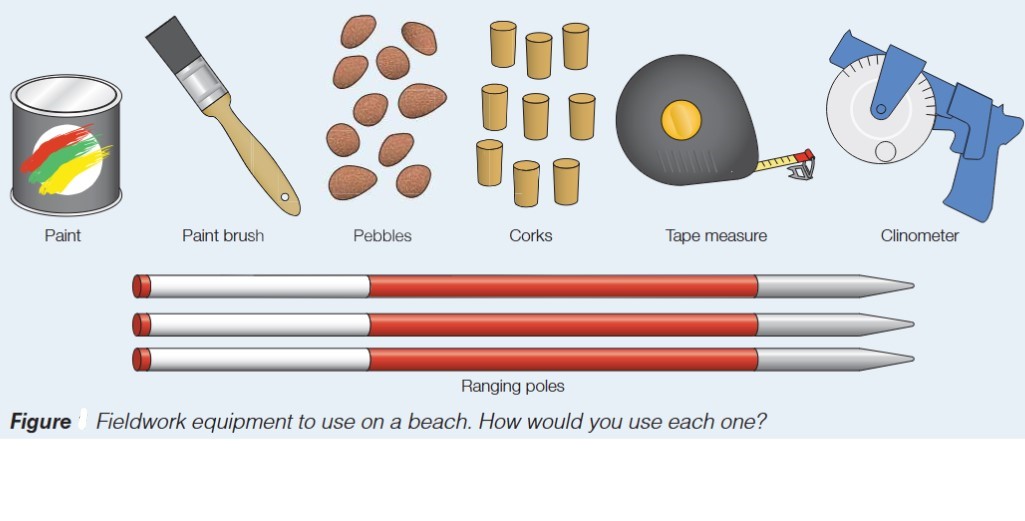
- Paint and paintbrushes: Used to mark stones or pebbles for wave surveys and sediment tracking studies
- Pebbles: Sample materials that can be marked and tracked to study sediment movement
- Corks: Lightweight floating objects that can be used to measure water movement and current direction
- Tape measure: Essential for measuring distances, beach widths, and spacing between features
- Clinometer: A specialized device for measuring angles of slope, crucial for creating accurate beach profiles
- Ranging poles: Vertical markers used to establish straight survey lines and measure heights or depths
Safety considerations
The most critical aspect of any fieldwork is ensuring the safety of all participants. Before conducting coastal fieldwork, you must complete a thorough risk assessment.
Risk Assessment is Mandatory
Never begin fieldwork without completing a comprehensive risk assessment. This isn't optional – it's an essential safeguard that protects everyone involved and ensures fieldwork can be conducted responsibly and safely.
This involves:
- Identifying potential hazards (such as incoming tides, slippery rocks, unstable cliffs, or deep water)
- Assessing the likelihood and severity of risks
- Implementing control measures to minimize dangers
- Ensuring appropriate supervision and emergency procedures are in place
- Checking weather forecasts and tide times
- Ensuring appropriate clothing and equipment are worn
Planning a river fieldwork investigation
Reasons for conducting river fieldwork
Rivers and coastal areas both offer valuable opportunities for geographical fieldwork, though each presents different advantages:
Rivers provide excellent locations for observing geomorphic processes in action. You can witness how flowing water shapes the landscape through erosion, transportation, and deposition. The river channel, its load, and surrounding valley features provide tangible evidence of these processes.
River systems demonstrate the full cycle of fluvial processes within relatively small areas, making them ideal outdoor laboratories for understanding landscape formation and change over time.
River environments offer practical opportunities for data collection through measurement, counting, and surveying techniques. The linear nature of rivers makes them ideal for systematic sampling along the channel's length, allowing you to investigate how river characteristics change downstream.
Like coastal fieldwork, river investigations can be enjoyable and engaging, but safety must always be the primary consideration. Never enter water that is too deep, fast-flowing, or cold, and always work under proper supervision with appropriate safety measures in place.
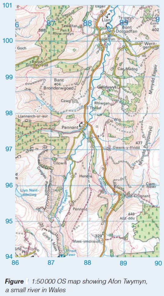
Site selection factors
Not all rivers are suitable for fieldwork purposes. When selecting a river location or specific sites along a river for investigation, several important factors must be considered:
Size of the river The river's width and depth are crucial considerations. Sites should be accessible and safe, meaning the water should be shallow enough to wade in safely (typically no more than knee-deep) and narrow enough to measure across effectively. Very large or deep rivers pose significant safety risks and practical difficulties.
River flow Water should be flowing at a moderate pace – fast enough to be measurable but not so rapid that it creates hazards. Completely dry channels offer no opportunity to measure flow, while very fast currents are dangerous and make accurate measurements difficult.
Land ownership and access You must be able to legally and safely access the river location. This means obtaining permission from landowners when necessary and ensuring there is safe access to and from the site without trespassing on private land or crossing hazardous terrain.
Site Selection Priorities
Safety must be the primary factor in site selection. A theoretically perfect site that poses safety risks is not suitable for fieldwork. Always prioritize accessible, safe locations over ideal but hazardous ones, even if this means compromising on some investigation objectives.
River fieldwork methods
Several specialized methods have been developed for investigating river characteristics and processes:
Channel survey This fundamental method involves measuring the width and depth of the river at points along its length. By taking regular measurements across the channel (typically at equal intervals), you create a cross-sectional profile showing the channel's shape. This data reveals information about channel morphology and can be compared between different sites to identify downstream changes.
Flow survey This technique measures the speed of water flowing along the river channel. Common methods include timing floating objects over a set distance or using a flow meter. By measuring flow velocity at different points across and along the channel, you can identify patterns in water movement and calculate discharge (volume of water flowing past a point per second).
Worked Example: Calculating River Discharge
Step 1: Measure channel width: 4.2 m
Step 2: Divide the channel into sections and measure depth at each point to calculate cross-sectional area:
Step 3: Measure flow velocity using a flow meter at multiple points:
Step 4: Calculate discharge using the formula:
Interpretation: This moderate discharge value suggests the river is flowing at a typical rate for a small river system.
River load survey This method focuses on measuring the shapes and sizes of sediment (the river's load) along the channel. By examining sediment characteristics such as particle size, roundness, and sorting at different sites, you can identify patterns that reflect transport processes. Generally, sediment becomes smaller and more rounded in a downstream direction due to attrition.
Valley slope survey This technique involves measuring the gradient of the valley sides along the river. Using clinometers and ranging poles, you can measure slope angles at different heights up the valley side. This data provides information about valley morphology and can indicate different stages of river development.
Water quality survey This method assesses the ecological health of the river by counting living organisms in the water. Different organisms have different tolerances to pollution, so the species present indicate water quality. Sites with many pollution-sensitive species have good water quality, while sites dominated by pollution-tolerant species indicate poorer conditions.
Water quality surveys using biotic indices provide a cost-effective, practical method for assessing river health. The presence or absence of indicator species like mayfly nymphs (clean water) or tubifex worms (polluted water) reveals environmental conditions without expensive chemical testing equipment.
Key Points to Remember:
-
Fieldwork investigations must follow a structured six-stage process: formulating a question, selecting methods, processing data, analysing findings, drawing conclusions, and evaluating the investigation.
-
Coastal fieldwork methods include beach profile surveys, beach material surveys, wave surveys, coastal management surveys, and cost/benefit analysis – each providing different insights into coastal processes and management.
-
River fieldwork methods include channel surveys, flow surveys, river load surveys, valley slope surveys, and water quality surveys – enabling investigation of river characteristics and downstream changes.
-
Risk assessment is an essential preparation for all fieldwork, identifying hazards and implementing safety measures to protect participants.
-
Site selection for river fieldwork must consider the river's size, flow rate, and accessibility, ensuring locations are both suitable for investigation and safe for participants.