River Landforms (OCR GCSE Geography B (Geography for Enquiring Minds)): Revision Notes
River Landforms
Introduction
Rivers are powerful forces that continuously shape the landscape as they flow from their source (starting point) to their mouth (where they meet the sea). Throughout this journey, rivers create distinctive landforms through two main processes: erosion (wearing away rock and soil) and deposition (dropping transported material). Understanding how rivers change along their course is essential for explaining the varied landscapes found across the UK.
As rivers flow from source to mouth, they pass through three distinct stages - the upper course, middle course, and lower course. Each stage has unique characteristics that determine which landforms develop and which processes dominate.
The three stages of a river
As a river flows from source to mouth, it passes through three distinct stages. Each stage has different characteristics that influence which landforms develop.
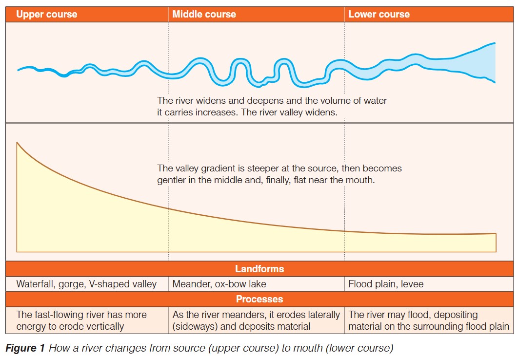
Upper course
The upper course is found closest to the river's source, typically in upland areas.
River characteristics:
- The channel is narrow and shallow
- Water flows rapidly due to the steep gradient
- The river carries relatively little water (low volume)
Valley characteristics:
- V-shaped valley with steep sides
- Very steep gradient (the river bed drops sharply in height)
- Narrow valley floor
Why these features occur:
In the upper course, the river has significant energy due to its steep gradient. This energy is directed downwards, causing vertical erosion - the river cuts down into the landscape like a knife, creating the characteristic V-shaped valley. The steep valley sides are also shaped by weathering and mass movement, as loosened material falls into the river channel.
Middle course
The middle course lies between the upland source and the lowland mouth.
River characteristics:
- The channel becomes wider and deeper than in the upper course
- Water flow is moderate in speed
- The volume of water increases as tributaries join the main river
Valley characteristics:
- The valley widens considerably
- The gradient becomes gentler (less steep)
- A wider valley floor begins to develop
Why these features occur:
As the gradient decreases, the river's energy shifts from cutting down to cutting sideways. Lateral erosion (sideways erosion) becomes the dominant process, causing the river to develop large bends called meanders. The river erodes material from the outer banks of bends (where flow is fastest) and deposits material on the inner banks (where flow is slower). This combination of erosion and deposition creates the distinctive winding pattern of the middle course.
Lower course
The lower course is found in lowland areas approaching the river's mouth.
River characteristics:
- The channel is at its widest and deepest
- Water flows slowly due to the very gentle gradient
- The river carries a large volume of water
Valley characteristics:
- Very wide valley with gentle slopes
- Almost flat gradient
- Extensive flat valley floor
Why these features occur:
In the lower course, the river has minimal energy for erosion due to the flat land. Instead, deposition becomes the main process. The river deposits the material it has been carrying, building up the valley floor. When the river floods, it spreads across the surrounding land, depositing layers of sediment (alluvium) to create extensive flat areas.
River landforms explained
Upper course landforms
Waterfall
Waterfalls form where the river flows over bands of hard and soft rock. The soft rock erodes more quickly than the hard rock, creating a step. As water plunges over the step, it erodes the soft rock beneath, undercutting the hard rock above. Eventually, the overhanging hard rock collapses, and the waterfall retreats upstream.
The process of waterfall formation involves a continuous cycle of undercutting (erosion of soft rock beneath hard rock), collapse (falling of overhanging hard rock), and retreat (waterfall moving upstream). This is why waterfalls are not permanent features - they gradually move back towards the river's source over thousands of years.
Gorge
A gorge is a steep-sided valley formed as a waterfall retreats upstream over time. The collapsed rocks are swept away by the river, leaving behind vertical or near-vertical valley sides.
V-shaped valley
These distinctive valleys are carved by vertical erosion in the upper course. The river cuts down into the landscape, while weathering and mass movement of material down the steep valley sides create the V-shape profile.
Middle course landforms
Meander
Meanders are large bends in the river channel. They form through a combination of erosion and deposition. The river flows fastest on the outside of bends (where the channel is deeper), causing erosion and creating river cliffs. On the inside of bends (where flow is slower and the channel is shallower), deposition occurs, forming slip-off slopes or point bars.
The formation of meanders demonstrates the relationship between water velocity and river processes. Fast-flowing water on the outer bend has more energy for erosion, while slow-flowing water on the inner bend has less energy and deposits its load instead.
Ox-bow lake
An ox-bow lake is a curved lake formed when a meander becomes cut off from the main river channel. This happens when erosion on the outer bends of a meander causes the neck of the meander to become narrower. During a flood, the river may cut through the neck, taking the shorter route. Deposition seals off the old meander bend, leaving a horseshoe-shaped lake.
Lower course landforms
Flood plain
A flood plain is the wide, flat area of land on either side of a river in its lower course. It forms through repeated flooding. When the river overflows its banks, it deposits layers of fertile sediment (alluvium) across the surrounding land. Over time, these deposits build up to create an extensive flat area.
Flood plains are some of the most fertile agricultural land because the alluvium deposited by rivers is rich in nutrients. This is why many ancient civilizations developed along river valleys.
Levee
Levees are natural embankments (raised banks) that run alongside the river channel. They form during floods when the river deposits its heaviest material (coarse sediment) first, immediately next to the channel. With each flood, the levees grow higher. Some levees are built up artificially to prevent flooding.
Summary of river changes from source to mouth
Key changes from source to mouth:
The table below summarizes how river and valley characteristics change systematically as the river flows from its source in upland areas to its mouth in lowland areas.
| Feature | Upper course | Middle course | Lower course |
|---|---|---|---|
| River width | Narrow | Wider | Widest |
| River depth | Shallow | Deeper | Deepest |
| Water velocity | Fast | Moderate | Slow |
| Volume of water | Low | Increasing | High |
| Valley width | Narrow | Wider | Very wide |
| Valley gradient | Steep | Gentler | Almost flat |
| Main landforms | Waterfall, gorge, V-shaped valley | Meander, ox-bow lake | Flood plain, levee |
| Main processes | Vertical erosion | Lateral erosion and deposition | Deposition |
Key terms
- Source: The starting point of a river, usually in upland areas.
- Mouth: The point where a river flows into the sea or a lake.
- Erosion: The wearing away and removal of rock, soil and sediment by the river.
- Deposition: The dropping or laying down of material that the river has been transporting.
- Vertical erosion: Downward erosion where the river cuts down into its bed, deepening the valley.
- Lateral erosion: Sideways erosion where the river erodes its banks, widening the valley.
- Gradient: The steepness of the river bed or valley slope, measured as the change in height over a distance.
- Channel: The route along which the river flows, contained within its banks.
- Alluvium: Fine, fertile sediment deposited by a river, particularly on flood plains.
Exam guidance
Essential exam tips:
Describe questions: State the characteristics clearly. For example, "The river is narrow and shallow in the upper course" or "A V-shaped valley has steep sides and a narrow valley floor."
Explain questions: Link processes to landforms. For example, "A waterfall forms because vertical erosion occurs where the river flows over hard and soft rock. The soft rock erodes faster, creating a step that grows into a waterfall as undercutting and collapse continue."
Compare questions: Use comparative language. For example, "The upper course has a steep gradient whereas the lower course has an almost flat gradient" or "Vertical erosion dominates in the upper course but deposition is the main process in the lower course."
Common errors to avoid:
- Don't confuse erosion with weathering (weathering breaks down rock in place without removing it)
- Remember that deposition occurs when the river loses energy and can no longer carry its load
- Don't forget that all three processes (vertical erosion, lateral erosion, and deposition) can occur to some extent at all stages - but one dominates at each stage
Remember!
Key Points to Remember:
-
Rivers pass through three distinct stages from source to mouth: upper course (steep, narrow, fast-flowing), middle course (moderate gradient, wider, meandering), and lower course (flat, widest, slow-flowing).
-
The dominant process changes along the river's course: vertical erosion in the upper course creates waterfalls, gorges and V-shaped valleys; lateral erosion and deposition in the middle course form meanders and ox-bow lakes; deposition in the lower course creates flood plains and levees.
-
River characteristics change systematically from source to mouth: the channel becomes wider and deeper, velocity decreases, water volume increases, and the valley widens while the gradient becomes gentler.
-
Understanding the relationship between processes (erosion and deposition) and landforms is crucial for explaining how rivers shape distinctive landscapes across the UK.
-
Always link the river's energy level to the processes and landforms found at each stage - high energy means more erosion, low energy means more deposition.