The Jurassic Coast (OCR GCSE Geography B (Geography for Enquiring Minds)): Revision Notes
The Jurassic Coast
Introduction
The Jurassic Coast is a remarkable stretch of coastline that extends for 155 kilometres along the southern coast of England. It runs from Exmouth in Devon in the west to Poole in Dorset in the east. This coastline is geologically significant because it is composed of layers of sedimentary rock that were formed over millions of years, providing a unique window into Earth's ancient past.
The coast is designated as a UNESCO World Heritage Site due to its outstanding geological features. The rocks here tell the story of approximately 185 million years of Earth's history, making it an exceptional location for understanding how geological processes shape landscapes.
Geological periods and rock formation
The rocks along the Jurassic Coast were formed during different geological time periods, each with distinctive environmental conditions that influenced the type of rock created.
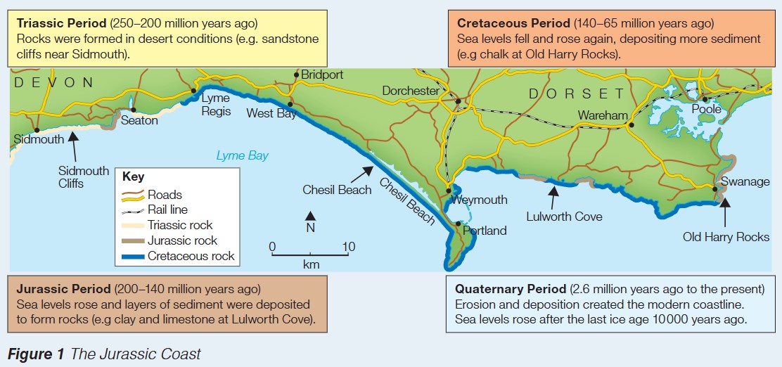
Triassic period (250-200 million years ago)
During the Triassic period, the area that is now the Jurassic Coast experienced desert conditions. These hot, dry environments led to the formation of distinctive red sandstone rocks. You can see excellent examples of Triassic rocks in the red sandstone cliffs near Sidmouth in Devon. The red colour comes from iron oxide, which formed as minerals were deposited in the desert environment.
Key term: Triassic period - The geological time period from 250 to 200 million years ago, characterised by desert conditions that created red sandstone formations.
Jurassic period (200-140 million years ago)
The Jurassic period saw significant environmental changes. Sea levels rose, covering much of the land with warm, shallow seas. As organisms died and sediment was transported by rivers, layers of material were deposited on the sea floor. Over time, these deposits were compressed and cemented together to form sedimentary rocks, particularly clay and limestone.
Example Location: Lulworth Cove
Lulworth Cove provides an excellent example of Jurassic rocks, where you can observe both clay and limestone layers. These rocks contain fossils of marine creatures that lived in the ancient seas.
Key term: Sedimentary rock - Rock formed from compressed layers of sediment (particles of rock, minerals, and organic material) that have been deposited over time.
Cretaceous period (140-65 million years ago)
During the Cretaceous period, sea levels fluctuated, falling and then rising again. When sea levels were high, vast quantities of sediment were deposited on the sea floor. The most distinctive rock type formed during this period is chalk, which is made from the compressed remains of countless microscopic marine organisms.
Example Location: Old Harry Rocks
Old Harry Rocks near Swanage provide a spectacular example of Cretaceous chalk formations. These white cliffs are composed almost entirely of chalk and stand out dramatically against the sea.
Key term: Chalk - A soft, white, porous sedimentary rock made from the skeletal remains of tiny marine organisms called coccolithophores.
Quaternary period (2.6 million years ago to present)
The Quaternary period is the most recent geological time, continuing to the present day. During this period, processes of erosion and deposition have shaped the modern coastline we see today. The last ice age ended approximately 10,000 years ago, and as the ice melted, sea levels rose significantly. This rising sea level, combined with wave action and weathering, has created the distinctive landforms we observe along the Jurassic Coast today.
Key term: Erosion - The wearing away and removal of rock and sediment by natural processes such as waves, wind, and ice.
Key term: Deposition - The process by which sediment and particles are deposited in a new location, often creating new landforms.
Case study: Lulworth Cove
Lulworth Cove is one of the most famous landforms along the Jurassic Coast and provides an excellent example of how different rock types interact with coastal processes.
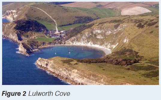
Formation and structure
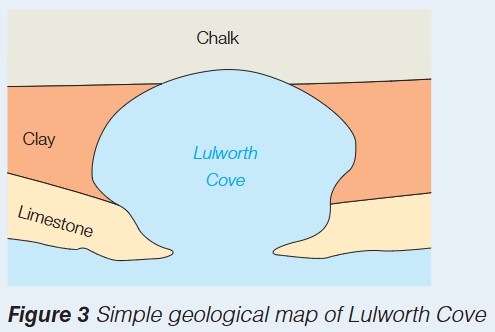
Lulworth Cove is a circular bay that has been formed through differential erosion. The coastline here consists of three distinct rock layers:
- Chalk - forming the outer cliffs on either side of the cove
- Clay - a softer rock layer that has been easily eroded
- Limestone - a resistant rock that initially protected the softer rocks behind it
How Lulworth Cove formed
Worked Example: Formation of Lulworth Cove through Differential Erosion
The formation of Lulworth Cove demonstrates the principle of differential erosion:
Step 1: Initially, a band of resistant Portland limestone protected the coastline from wave attack
Step 2: Over time, waves exploited a weakness in the limestone, creating a small gap
Step 3: Once the waves breached the limestone barrier, they reached the softer clay behind
Step 4: The clay eroded much more rapidly than the harder rocks, creating a wide bay
Step 5: The erosion slowed when waves reached the more resistant chalk at the back of the bay
Step 6: The result is the distinctive horseshoe-shaped cove we see today
Geological significance
Lulworth Cove clearly shows how geology influences coastal landforms. The different rock layers - limestone, clay, and chalk - each respond differently to erosional processes. This creates a landscape where resistant rocks form headlands and cliffs, while softer rocks are eroded to form bays.
Exam tip: When describing Lulworth Cove in an exam, always mention the three rock types (limestone, clay, chalk) and explain how their different resistances to erosion led to the cove's formation. Use the term "differential erosion" to show your understanding of the process.
Distinctive landforms along the coast
The Jurassic Coast features numerous distinctive landforms created by the interaction between geology and coastal processes:
- Old Harry Rocks - chalk stacks formed by erosion of a headland
- Lulworth Cove - a circular bay carved from layers of limestone, clay and chalk
- Chesil Beach - a large shingle beach formed by deposition
- Durdle Door - a natural limestone arch created by wave erosion
Each of these landforms has been shaped by the underlying geology and the erosional or depositional processes acting upon it over thousands of years.
Exam tip: You may be asked to name and describe distinctive landforms along the Jurassic Coast. Make sure you can:
- Identify whether each feature was formed primarily by erosion or deposition
- State the geological period it dates from
- Name the rock type(s) involved
Remember!
Key Points to Remember:
- The Jurassic Coast extends for 155km from Exmouth in Devon to Poole in Dorset
- The coastline displays rocks from four geological periods: Triassic (250-200 mya), Jurassic (200-140 mya), Cretaceous (140-65 mya), and Quaternary (2.6 mya-present)
- Different rock types formed under different environmental conditions: red sandstone in deserts (Triassic), limestone and clay in warm seas (Jurassic), and chalk from marine organisms (Cretaceous)
- Lulworth Cove demonstrates differential erosion, where resistant limestone was breached, allowing softer clay to erode rapidly, creating a circular bay backed by harder chalk
Key Terms to Remember:
- Sedimentary rock, chalk, clay, limestone
- Erosion and deposition
- Differential erosion
- Geological periods (Triassic, Jurassic, Cretaceous, Quaternary)
Key Processes:
- Rock formation through deposition and compression of sediments over millions of years
- Differential erosion creating distinctive coastal landforms based on rock resistance
- Rising sea levels after ice ages shaping the modern coastline