Upland and Lowland Landscapes (OCR GCSE Geography B (Geography for Enquiring Minds)): Revision Notes
Upland and Lowland Landscapes
Distribution of uplands and lowlands in the UK
Britain can be divided into two main landscape types based on relief (height of the land): uplands and lowlands.
Uplands are areas of higher ground located predominantly in the north and west of the UK. These include:
- Scotland
- Wales
- Northern England
Lowlands are areas of lower ground found mainly in the south and east of the UK. This includes most of central and southern England.
A clear boundary separates these two landscape zones. An imaginary dividing line runs from the Bristol Channel in the southwest to Flamborough Head in Yorkshire. This line effectively splits the UK into upland areas to the northwest and lowland areas to the southeast.
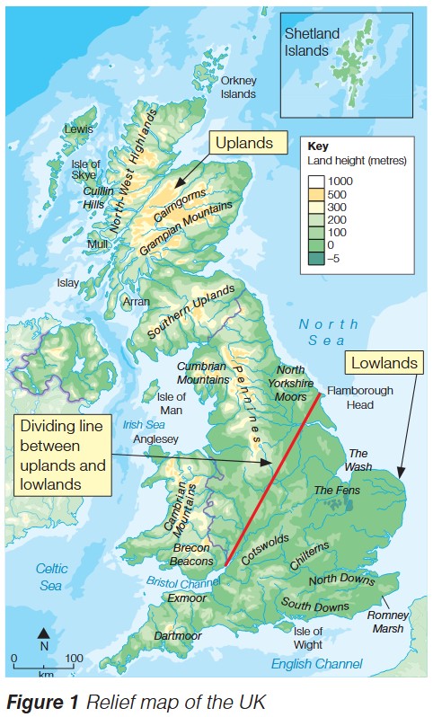
The relief map shows the stark contrast in elevation between these regions. Upland areas are characterized by higher elevations (shown in yellow and orange on the map), reaching over 1000 metres in places like the Scottish Highlands and Grampian Mountains. Lowland areas appear in green, indicating lower elevations typically below 200 metres, such as The Fens and the areas around The Wash.
How glaciation shaped UK landscapes
What is glaciation?
During the past 2.6 million years (known as the Quaternary Period), the UK has experienced multiple episodes of extreme cold. These periods are called ice ages or glaciation, when large parts of the country were covered by thick ice sheets. Between these ice ages were warmer phases called interglacial periods.
Glaciation has been one of the most powerful forces shaping Britain's distinctive landscapes, affecting both upland and lowland areas in different ways.
Impact on upland landscapes
Glaciation transformed upland areas through several key processes:
Formation of mountain peaks and ridges – Moving ice eroded the landscape, creating sharp mountain peaks and prominent ridges. The Scottish Highlands and Welsh mountains show clear evidence of glacial erosion in their rugged, angular profiles.
Worked Example: U-shaped Valley Formation
Carving of U-shaped valleys – Glaciers acted like enormous bulldozers, carving out deep, wide valleys with characteristic U-shaped cross-sections.
Key characteristics:
- Steep, straight sides
- Flat valley floors
- Very different from V-shaped valleys created by rivers
Where to find them: Examples can be found throughout upland Britain, particularly in the Lake District and Scottish Highlands.
Impact on lowland landscapes
Lowland areas were also significantly affected by glaciation, though in different ways:
Freezing of the ground – In areas beyond the ice sheets, the ground was permanently frozen (periglacial conditions). This freezing and thawing created distinctive landscape features and river valleys.
Formation of dry valleys – When the ice eventually melted, it left behind dry valleys – valley-shaped landforms that no longer contain rivers. These valleys were created when meltwater flowed over frozen ground, but once conditions warmed and the ground became permeable again, the water soaked away, leaving the valleys dry. The South Downs in southern England contain many examples of dry valleys.
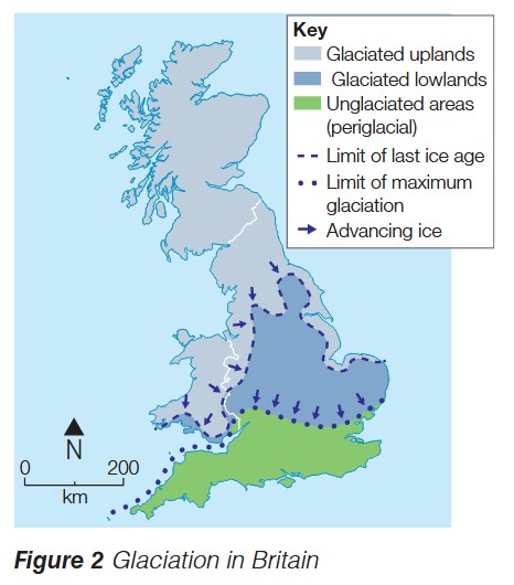
The glaciation map reveals the extent of ice coverage during the ice ages. Glaciated uplands (light blue) cover most of Scotland and parts of northern England and Wales. Glaciated lowlands (darker blue) extend across central England. The unglaciated periglacial areas (green) cover southern England, which experienced freezing conditions but were not covered by ice sheets. The arrows show the direction of ice movement, generally flowing southward from Scotland.
Exam guidance
Essential Exam Skills
When answering questions about upland and lowland landscapes:
Describe questions require you to identify and provide details about patterns and features you can see. For example, describe the distribution of uplands (location: north and west, specific areas: Scotland, Wales, northern England).
Explain questions need you to give reasons and processes. For example, explain how glaciation created U-shaped valleys (reference to erosive power of ice, processes of plucking and abrasion).
Always use specific examples and accurate geographical terminology. Reference named locations from the UK where possible (e.g., Scottish Highlands, The Fens, South Downs).
Remember!
Key Points to Remember:
-
The UK is divided into uplands (north and west) and lowlands (south and east), separated by an imaginary line from the Bristol Channel to Flamborough Head
-
Glaciation occurred multiple times during the 2.6 million year Quaternary Period, when ice sheets covered much of Britain
-
Glaciation created distinctive upland features including mountain peaks, ridges, and deep U-shaped valleys
-
In lowland areas, glaciation caused ground freezing and created dry valleys when ice melted
-
Understanding the distribution of glaciated and unglaciated areas helps explain why different parts of the UK have such distinctive landscape characteristics