Drought, El Niño and La Niña (OCR GCSE Geography B (Geography for Enquiring Minds)): Revision Notes
Drought, El Niño and La Niña
Understanding weather extremes
Weather extremes such as droughts can have devastating impacts on people and environments around the world. Two major climate phenomena that drive these extremes are El Niño and La Niña. These events occur in the Pacific Ocean and influence global weather patterns, particularly rainfall distribution.
Weather extremes are becoming increasingly important to understand as they affect agriculture, water resources, and human societies worldwide. El Niño and La Niña are among the most significant drivers of these extremes.
What are El Niño and La Niña?
El Niño and La Niña are naturally occurring climate events that result from variations in ocean temperatures across a band of the Pacific Ocean. These phenomena are opposite phases of the same climate cycle and are driven by changes in trade wind strength.
Definition: El Niño and La Niña are events caused by changes in the sea surface temperature (SST) in a band across the Pacific Ocean. They represent opposite extremes of the same climate cycle.
The role of trade winds
Trade winds are persistent easterly winds that normally blow from east to west across the Pacific Ocean. The strength of these winds determines whether an El Niño or La Niña event develops. Understanding this relationship is crucial for predicting weather patterns and potential droughts.
The trade winds act like a giant conveyor belt, pushing warm surface water across the Pacific. When this "conveyor belt" speeds up or slows down, it triggers major changes in ocean temperatures and global weather patterns.
El Niño conditions
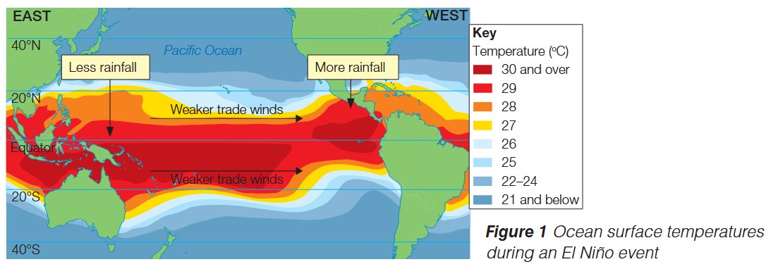
El Niño occurs when the trade winds weaken. This weakening allows warm water to accumulate in the central and eastern Pacific Ocean, raising sea surface temperatures. The warming of the ocean surface disrupts normal atmospheric circulation patterns, leading to significant changes in global weather.
During an El Niño event, ocean temperatures in the equatorial Pacific can rise by several degrees Celsius above normal. This temperature increase has far-reaching consequences for rainfall distribution across the globe.
Key Mechanism: When the trade winds that blow from east to west are weaker, the surface temperature increases and causes the El Niño effect.
Think of it as: Weak winds = Warm water
La Niña conditions
La Niña represents the opposite situation. When trade winds strengthen beyond their normal intensity, they push warm surface water more effectively towards the western Pacific. This causes sea surface temperatures in the central and eastern Pacific to decrease below average, creating cooler than normal conditions.
The stronger trade winds during La Niña intensify the normal circulation patterns, leading to weather effects that are essentially the reverse of those during El Niño.
Key Mechanism: When the trade winds are stronger, the temperature decreases, causing a La Niña effect.
Think of it as: Strong winds = Cool water
Remember: La Niña is the opposite of El Niño - stronger winds, cooler temperatures, and reversed rainfall patterns.
Global impacts on rainfall patterns
El Niño and La Niña events have profound effects on global rainfall distribution, causing some regions to experience significantly wetter conditions while others face drought.
El Niño rainfall patterns
During El Niño events, the Australian and Asian edges of the Pacific Ocean typically receive less rainfall than normal. This reduction in precipitation often leads to drought conditions across Southeast Asia, Indonesia, Australia, and parts of southern Africa. Meanwhile, the Pacific coasts of North and South America experience increased rainfall, which can sometimes lead to flooding.
El Niño Pattern: Think "Australia DRIES when Americas get WETTER"
- Western Pacific (Australia, Southeast Asia): Drier conditions and drought
- Eastern Pacific (Americas): Wetter conditions and potential flooding
La Niña rainfall patterns
La Niña events reverse this pattern completely. Regions along the Australian and Asian edge of the Pacific receive above-average rainfall, while areas along the American Pacific coast tend to be drier than usual. This reversal means that La Niña can bring drought to the Americas while providing relief from dry conditions in Australia and Southeast Asia.
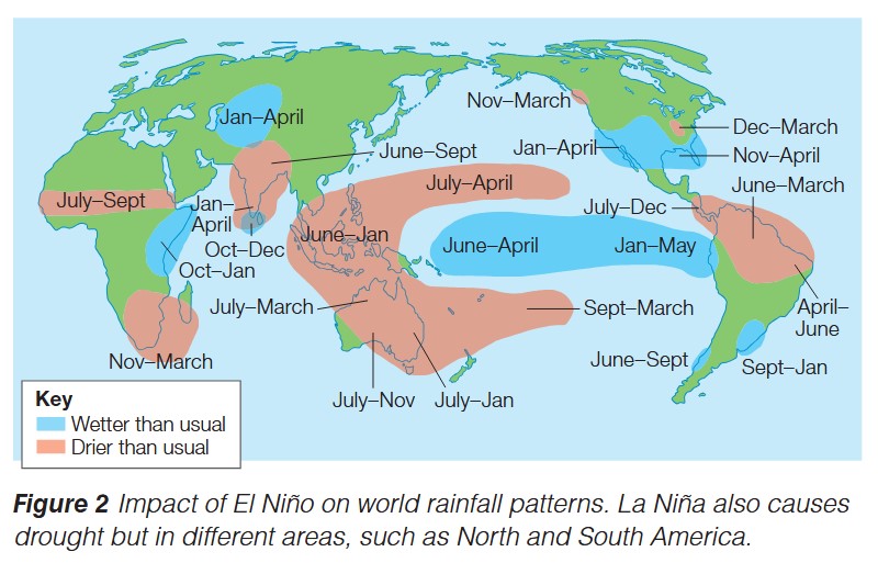
The world map above shows how different regions experience wetter or drier conditions during different times of the year as a result of El Niño and La Niña events. Notice how the impacts vary seasonally across different continents.
La Niña Pattern: The complete opposite of El Niño
- Western Pacific (Australia, Southeast Asia): Wetter conditions
- Eastern Pacific (Americas): Drier conditions and drought
The predictable nature of this reversal helps meteorologists forecast which regions are at risk during each event.
The link to droughts
The changes in rainfall patterns caused by El Niño and La Niña directly trigger droughts in affected regions. When an area that normally receives reliable rainfall suddenly experiences a significant reduction in precipitation, drought conditions develop rapidly.
Regional drought impacts
During El Niño years, countries around the western Pacific rim are particularly vulnerable to drought. This includes major agricultural regions in Australia, Indonesia, the Philippines, and Southeast Asia. These droughts can persist for months, severely impacting water supplies, crop production, and natural ecosystems.
Conversely, during La Niña years, drought risk shifts to different regions, particularly affecting parts of North and South America. The predictable nature of these shifts allows meteorologists to forecast drought risk and helps governments prepare response strategies.
Drought Vulnerability:
El Niño droughts typically affect:
- Australia
- Indonesia
- Philippines
- Southeast Asia
- Parts of southern Africa
La Niña droughts typically affect:
- Parts of North America
- Parts of South America
Understanding which phase is occurring allows for advance warning and preparation.
Case study: Thailand 2015 El Niño drought
The 2015 El Niño event provides a clear example of how these climate phenomena can create severe drought conditions with widespread consequences. Thailand experienced one of its worst droughts on record during this event, demonstrating the serious impacts El Niño can have on human activities and economies.
Case Study: Thailand 2015 El Niño Drought
Background: During the 2015 El Niño event, Thailand faced one of its most severe droughts in recent history, illustrating the real-world impacts of these climate phenomena.
Impacts on Agriculture:
- Crop failures across major rice-growing regions
- Livestock losses as water supplies dwindled
- Rice paddies particularly affected due to their high water requirements
- Farmers faced severe economic hardship
Economic Consequences:
- Food prices increased significantly across the country
- Economic hardship for both producers (farmers) and consumers
- Water shortages affected industrial production
- Hydroelectric power generation was reduced
- Government forced to implement emergency measures:
- Water rationing in major cities
- Financial support programs for affected farmers
Key Lesson: This case demonstrates how El Niño-driven droughts can cascade through entire economies, affecting multiple sectors and millions of people beyond just agriculture.
Exam guidance
When answering questions about El Niño and La Niña:
Exam Success Tips:
-
Describe questions: Focus on the pattern of trade winds, ocean temperature changes, and the spatial distribution of rainfall impacts
-
Explain questions: Link the weakening/strengthening of trade winds to temperature changes, then connect these to altered rainfall patterns and drought formation. Show the cause-and-effect chain
-
Case study questions: Use specific details from the Thailand 2015 example, including impacts on farmers, food prices, and the economy
-
Always use geographical terminology correctly (e.g., trade winds, sea surface temperature, precipitation patterns)
-
Be clear about the differences between El Niño and La Niña - they are opposite phenomena
Remember!
Key Points to Remember:
-
El Niño occurs when trade winds weaken, causing warmer sea surface temperatures in the Pacific Ocean
-
La Niña occurs when trade winds strengthen, causing cooler sea surface temperatures in the Pacific Ocean
-
El Niño brings drought to Australia and Southeast Asia but increased rainfall to the Americas
-
La Niña reverses this pattern, bringing drought to different regions
-
Memory aids:
- El Niño = "Warm baby" (warming effect)
- La Niña = "Cool girl" (cooling effect)
- Weak winds = Warm water (El Niño)
- Strong winds = Cool water (La Niña)
-
The 2015 Thailand El Niño drought severely impacted farmers, increased food prices, and damaged the economy, demonstrating the serious real-world consequences of these climate events