Rivers (Junior Cert Geography): Revision Notes
Rivers
River Stages
A river's long profile is divided into three main stages — the upper course, middle course, and lower course — each with distinct processes and landforms.
- Upper course (steep gradient): Characterised by vertical erosion, forming V-shaped valleys, interlocking spurs, waterfalls, rapids, and gorges.
- Middle course (gentle gradient): Lateral erosion and transportation dominate, creating meanders, river cliffs, and slip-off slopes.
- Lower course (very low gradient): Deposition is the main process, forming floodplains, oxbow lakes, levées, deltas, and estuaries.
| Stage | Main Activity | Main Features |
|---|---|---|
| Upper course (steep gradient) | Vertical (downward) erosion | Source, tributaries, V-shaped valley, interlocking spurs, waterfalls, rapids, gorges |
| Middle course (gentle gradient) | Lateral (sideways) erosion starts, transportation | River beaches (slip-off slopes), meanders, river cliffs |
| Lower course (very low gradient) | Deposition | Floodplains, oxbow lakes, levées, delta, estuary |
River Features
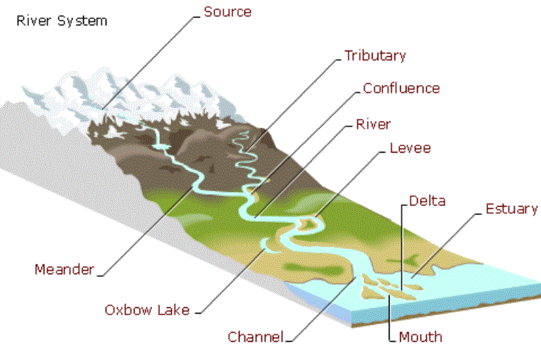
A river shapes the landscape as it flows from its source to the sea. Here are the key features of a river and its course:
- Source:
- The starting point of a river, usually found in high, mountainous areas.
- Tributaries:
- Smaller rivers or streams that flow into a larger river, meeting at a point called a confluence.
- Interlocking Spurs:
- Ridges of land that project into the river valley. They form as the river winds around harder rock while eroding the softer rock.
- Waterfalls:
- A steep drop in the river's course where water falls vertically. Waterfalls occur where there is a sudden change in the riverbed's elevation.
- Meanders:
- Broad curves or bends in the middle course of the river. Meanders form as the river erodes its outer banks and deposits material along the inner banks due to lateral erosion.
- Oxbow Lakes:
- U-shaped bodies of water formed when a meander is cut off from the main river, leaving behind a separate lake.
- Floodplain:
- The flat, wide area of land along a river, especially in its lower course. It is prone to flooding when the river overflows its banks.
- Mouth:
- The point where the river enters a larger body of water, such as a sea or ocean.
- Estuary:
- The tidal part of the river near its mouth, where fresh water mixes with saltwater from the sea. Sediment is often deposited here, creating deltas.
River Processes
Rivers shape the landscape through three main processes: erosion, transportation, and deposition. Each process plays a crucial role in how rivers change the land over time.
Erosion
Erosion occurs when a river wears away the land. There are four key types of river erosion:
- Hydraulic Action: The force of the moving water itself erodes the riverbank and bed, especially in faster-moving sections of the river. The pressure of the water can break rock apart.
- Abrasion: Rocks and sediment carried by the river grind against the bed and banks, wearing them down like sandpaper.
- Solution: Some rocks, like limestone, dissolve in the slightly acidic river water. This process occurs when the water contains carbonic acid, which gradually dissolves the minerals in the rock.
- Attrition: Rocks and stones carried by the river bump into each other, breaking into smaller, smoother pieces over time.
Transportation
Once eroded material is in the river, it gets transported downstream in several ways:
- Rolling: Large particles like boulders and pebbles are pushed along the riverbed by the force of the water. This is also known as traction.
- Bouncing: Smaller particles like sand and small stones are bounced along the riverbed in a process called saltation.
- Suspension: Fine materials, such as silt and clay, are lifted and carried within the water, giving the river a muddy appearance.
- Solution: Dissolved minerals are carried in the water, invisible to the naked eye. This material travels with the water itself.
Deposition
Deposition happens when a river loses energy and drops the material it has been carrying. This can occur for a few reasons:
- Decrease in Speed: When a river slows down, it doesn't have enough energy to carry large particles, so it drops them. This often happens where a river enters a lake or the sea.
- Decrease in Volume: If there is less water in the river, perhaps during a dry season, it can't carry as much material, so some of it is deposited along the riverbed.
- Increase in Load: After heavy rainfall or floods, a river may pick up more sediment than it can carry. As the river slows after the flood, it deposits this extra material along its course.
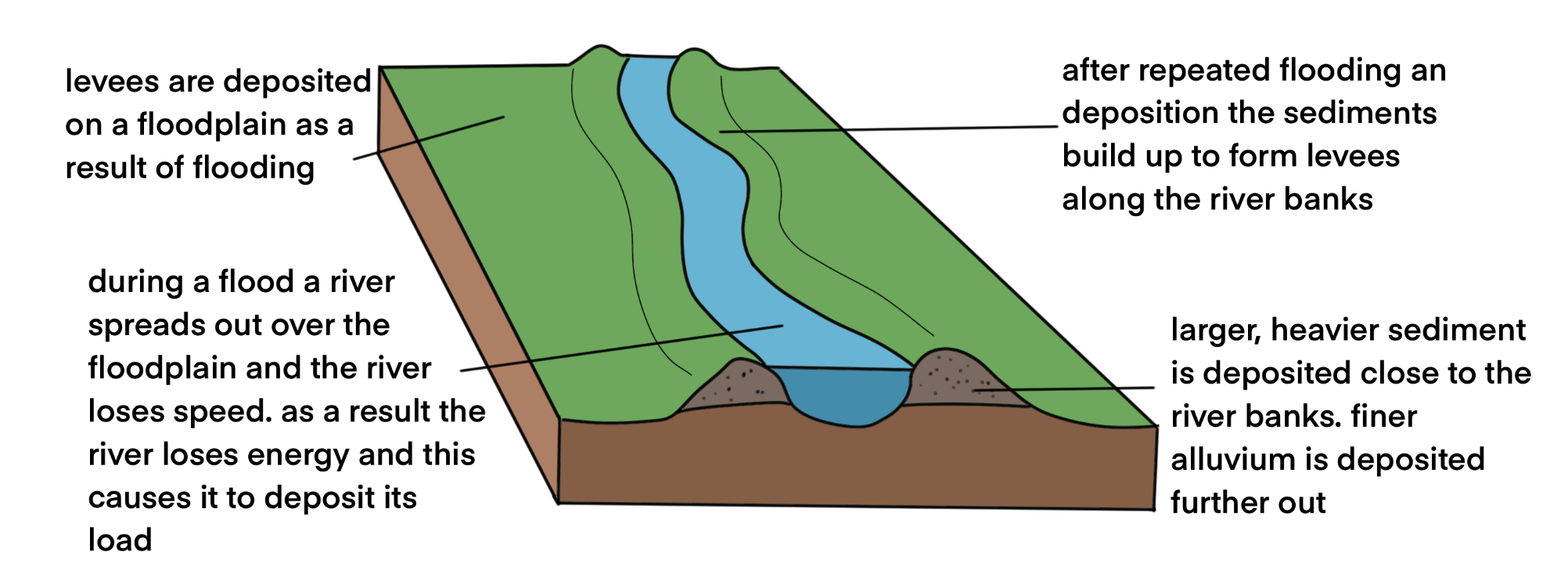
Feature of River Deposition: Levees
Levees are natural embankments made of alluvium (sediment) that form along the sides of a river in its lower course. They are created through the process of deposition during floods.
- Formation:
- Deposition on Floodplains: Levees form when a river overflows its banks during a flood, spreading out over the floodplain. As the water spreads, it slows down and loses energy, causing it to deposit the sediment it carries.
- Sediment Sorting: The heaviest sediment is dropped first, close to the riverbank, because it requires the most energy to be carried. Finer sediment is carried further away and deposited farther from the river.
- Build-Up Over Time: Repeated flooding causes layers of sediment to build up along the riverbanks. Over time, these deposits create raised ridges called levees.
- Location:
- Levees are typically found in the lower course of a river where the gradient is gentle and the river flows slowly. This makes deposition more likely during floods.
- Examples of levees can be found along rivers such as the River Moy in Co. Mayo. Levees help contain future floods by raising the height of the riverbanks, but if a flood is strong enough to breach the levees, the consequences can be severe.
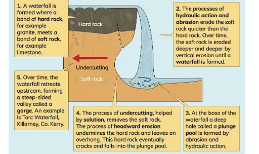
Feature of River Erosion: Waterfalls
A waterfall is a steep drop or vertical fall in the river channel, typically found in the upper course of a river. It forms through the process of erosion.
- Formation:
- Differential Erosion: Waterfalls develop where a river flows over layers of hard rock (e.g., granite) and soft rock (e.g., limestone). The soft rock erodes more quickly than the hard rock, creating a sudden drop.
- Erosion Processes: The force of the water (hydraulic action) and the grinding action of sediment (abrasion) wear away the softer rock, deepening the drop. The harder rock remains intact, forming the top of the waterfall.
- Undercutting and Plunge Pool Formation:
- Undercutting: The softer rock beneath the hard rock is eroded away by the river, a process called undercutting. This creates an overhang of hard rock, which eventually collapses due to lack of support.
- Plunge Pool: As the water falls, it erodes the riverbed at the base of the waterfall, forming a deep, circular plunge pool through continuous hydraulic action and abrasion.
- Retreat and Gorge Formation:
- Waterfall Retreat: Over time, the repeated collapse of the overhanging rock causes the waterfall to move upstream, creating a steep-sided valley or gorge.
- Example: A well-known example of a waterfall is Torc Waterfall in Killarney, Co. Kerry. Waterfalls are dramatic features of river erosion that continue to evolve as the river wears away the landscape.