Aerial Photographs (Junior Cert Geography): Revision Notes
Aerial Photographs
Aerial Photographs
Aerial photographs are images of the land surface taken from above, giving a unique perspective of landscapes, cities, and geographical features. They are useful for studying both physical and human features from the air.
Types of Aerial Photographs
There are two main types of aerial photographs:
- Vertical Photographs
- Taken with the camera pointing directly down at the area below.
- They show the land in a flat, "map-like" view, ideal for creating maps and measuring distances.
- Vertical photos provide a true scale image, allowing accurate mapping and analysis of the land.
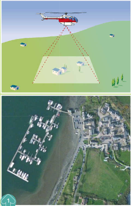
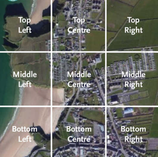
Vertical photos are taken from directly above and can be divided into a 3x3 grid with nine sections:
-
Top Left, Top Centre, Top Right
-
Middle Left, Middle Centre, Middle Right
-
Bottom Left, Bottom Centre, Bottom Right
-
This grid system helps identify the location of features by noting which section they primarily occupy.
-
Some vertical photos may include a north arrow. In these cases, use compass directions (e.g., North, North-East, South-West) to describe locations accurately.
- Oblique Photographs
- Taken with the camera looking down and across the area at an angle.
- These photos give a more three-dimensional view, showing the height and depth of features, making it easier to identify shapes and structures.
- Oblique photos are helpful for visualising the landscape in a way that shows the relative heights of buildings, hills, and other features.
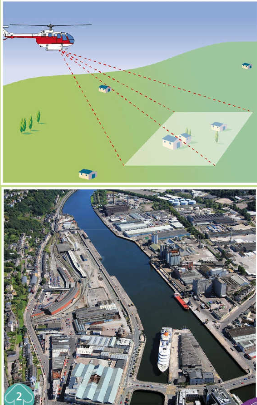
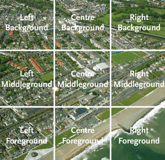
Oblique photos are taken at an angle, so they cover different areas based on distance from the camera. Divide the photo into three main horizontal sections:
-
Foreground (nearest to the camera)
-
Middleground (middle distance)
-
Background (farthest from the camera)
-
Each section can also be divided into Left, Centre, and Right:
- Left Foreground, Centre Foreground, Right Foreground
- Left Middleground, Centre Middleground, Right Middleground
- Left Background, Centre Background, Right Background
-
In oblique photos, features in the foreground appear larger than those in the background due to perspective, which helps in identifying objects closer to or farther from the camera.
Uses of Aerial Photographs
- Interpretation of Physical and Human Features: Helps in studying natural landscapes (like rivers, mountains, and forests) as well as human-made structures (like roads, buildings, and fields).
- Sketch Maps: Aerial photos can be used to draw sketch maps, highlighting key features in simplified form.
- Comparison with Maps: Comparing aerial photos with maps helps in understanding the layout, changes in land use, and development of areas over time.
How to Draw a Sketch Map of a Photograph
Drawing a sketch map of an aerial photograph is a valuable skill, often required in Junior Cert exams. A sketch map simplifies a photograph by highlighting key features, helping you focus on important elements without unnecessary details.
Steps for Drawing a Sketch Map
- Draw the Frame:
- Begin by drawing a rectangular frame for your sketch map. The shape should match the photograph, but typically scaled down (e.g., half the width and half the length).
- Divide into Segments:
- Lightly divide both the photograph and your sketch map frame into segments, in a grid. This grid will help you accurately place features.
- Draw the Coastline, Skyline, and Horizon:
- If visible in the photograph, start by sketching in the coastline, skyline, and horizon. These lines create the basic "shape" of the map.
- Add Required Features:
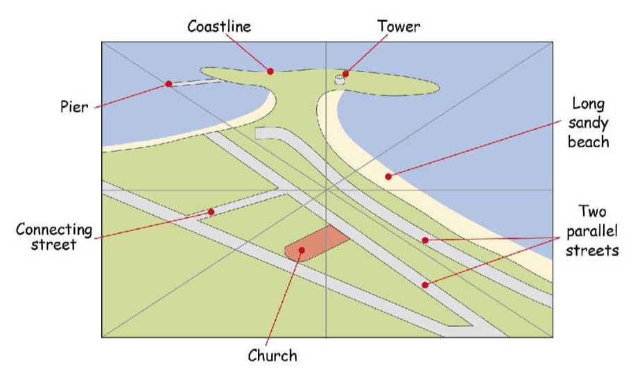
- Draw in and label the specific features required (e.g., roads, rivers, beaches, towers). Begin with rivers or roads, as they help to locate other features in relation to them.
- Label each feature clearly, leaving plenty of space for labels around the map.
- Add a Title and North Arrow:
- Give your sketch map a title.
- Include a north arrow to show direction, especially if it is indicated on the original photograph.
Useful Tips for Drawing Sketch Maps
- Always use a pencil to allow for corrections.
- Only draw the features specified in the question.
- Label all features requested.
- Use double lines for major roads, railways, or rivers.
- Avoid using colour, as it is usually unnecessary.
- Do not attempt to trace or copy exact details from the photograph—keep it simple and focus on the most important elements.
Understanding Aerial Photographs: Colour, Settlement, and Land Use
Aerial photographs reveal information about land use, settlement types, and even the season based on specific visual clues.
Colour and Identifying Features in Aerial Photographs
Colours in aerial photos help identify different land uses and features:
- Pastureland: Appears green; darker green indicates thicker grass or mature crops.
- Trees: Conifers (evergreens) are dark green year-round, while deciduous trees are green in summer and bare in winter.
- Crops: Ripe cereals or hay are yellowish or golden.
- Ploughed Land: Brown, indicating freshly tilled soil.
- Water Bodies: Rivers, lakes, and seas vary from dark blue to silver, depending on light reflexion.
- Roads: Often light grey.
- Factory Roofs: Sometimes visible in light colours.
- Stone Buildings (Old Castles, Ruins): Typically grey.
- Shadows: Areas in shadow are darker, helping identify the direction of sunlight.
Identifying the Time of Year
Clues in aerial photographs can help approximate the season:
- In Summer:
- Trees and bushes are fully covered in foliage.
- Ripe crops or hay bales are visible in fields.
- Farm animals are often seen grazing in pastures.
- In Winter:
- Deciduous trees appear bare.
- Freshly ploughed fields are more common.
- Farm animals are typically absent, and chimney smoke may indicate cold weather.
Rural Settlement and Land Use
Aerial photographs can also reveal types of rural settlement and land use.
- Former (Historic) Settlement:
- Look for signs of ancient structures, such as:
- Defensive Sites: Castles, round towers, forts.
- Burial Sites: Graveyards, dolmens, standing stones.
- Religious Sites: Monasteries, old churches.
- Domestic Sites: Ruined or abandoned houses.
- Present-Day Settlement:
- Shown by modern houses, villages, and infrastructure. Settlement patterns (dispersed, nucleated, or linear) may also be visible.
- Land Use Types:
- Pastoral Farming: Green fields used for grazing cattle or sheep.
- Arable (Tillage) Farming: Brown fields for ploughed land and tan-coloured fields for cereal crops.
- Woodland: Large areas of trees; coniferous forests (dark green) or deciduous trees (seasonal colour changes).
- Buildings: Dwellings, barns, or industrial structures.
- Transport: Roads, railways, and paths.
- Recreational Land: Parks, sports grounds, and golf courses.
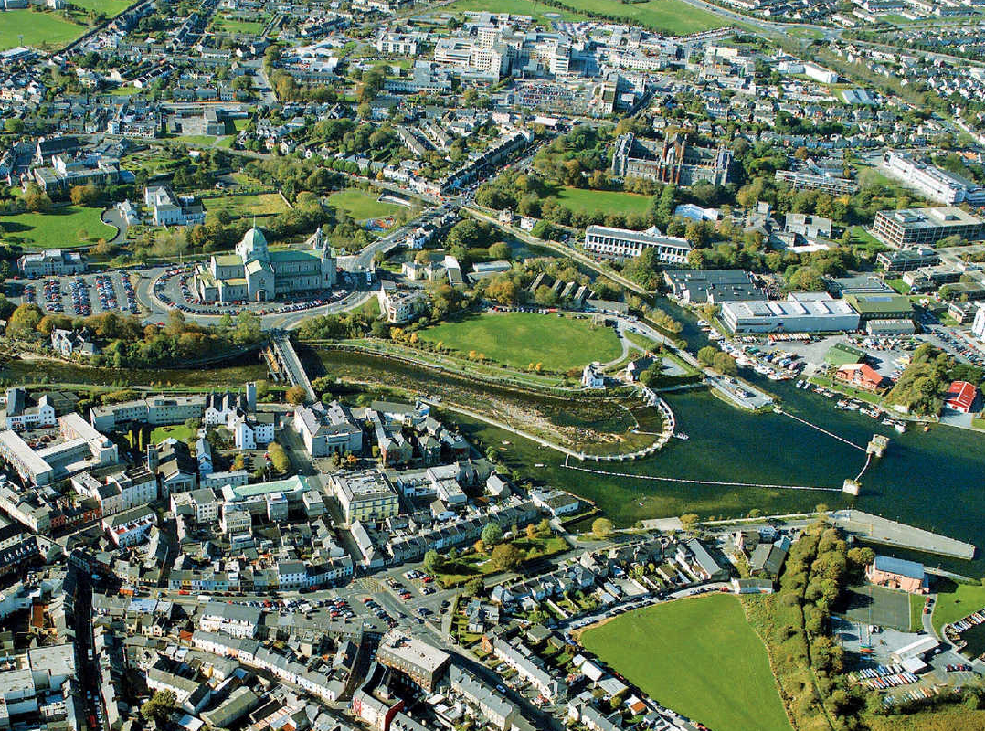
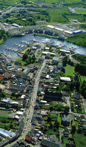
Urban Settlement – Towns and Cities
Urban areas, especially towns and cities, develop based on specific factors and serve various functions. When examining urban areas in aerial photographs or on maps, it's helpful to understand why towns are located where they are, the functions they serve, and the challenges they face, such as traffic congestion.
Factors Influencing the Location of Towns
- Flat or Gently Sloping Land: Easier to build on, so it encourages development.
- Transport Routes: Towns often develop at the meeting points of roads, railways, or waterways.
- Bridging Points: Towns may form where a river can be easily crossed.
- Coastal Locations: Access to the sea supports trade, fishing, and tourism.
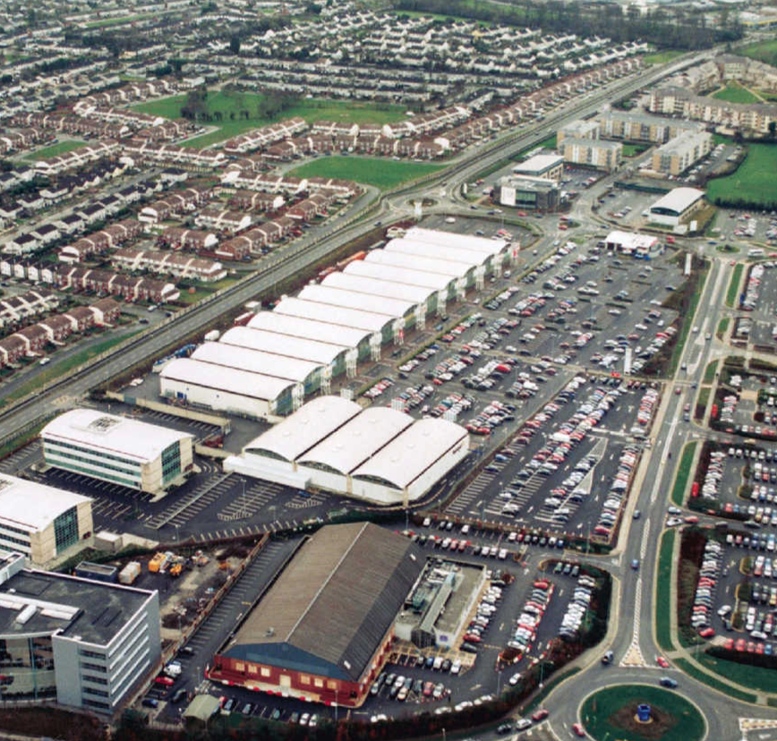
Urban Functions and Services Visible in Aerial Photographs
Towns serve multiple functions, often providing different services.
Functions:
-
Residential: Houses, apartments.
-
Industrial: Factories, industrial estates. Functions that are also services:
-
Retail and Commercial: Shops, shopping centres, office blocks.
-
Religious: Churches, abbeys.
-
Transport: Roads, railways, ports, canals.
-
Recreational: Sports fields, parks, playgrounds.
-
Tourism: Hotels, beaches, tourist attractions.
-
Medical: Hospitals.
-
Educational: Schools, colleges.
-
Ports: Cargo docks, cranes, and warehouses. Former (Historic) Functions:
-
Defensive: Castles, towers, town walls.
-
Commercial: Former warehouses and town squares that may have been used for markets.
The Central Business District (CBD)
- The Central Business District is the main commercial area in a town or city.
- It is usually located in the town centre and includes the principal street or main streets.
- Shops and commercial premises are concentrated in this area.
- Buildings in the CBD are often taller than buildings in other parts of the town.
Economic Activities and Photographs
Economic activities in urban areas can be divided into three categories:
- Primary Activities:
- Extract natural resources from land or sea, such as farming, fishing, or mining.
- Look for fields, farm buildings, boats, ports, and quarries.
- Secondary Activities:
- Involve manufacturing and industrial production.
- Indicated by factories and industrial estates.
- Tertiary Activities:
- Provide services like transportation, education, healthcare, and tourism.
- Include schools, hospitals, shops, and recreational facilities like golf courses or marinas.
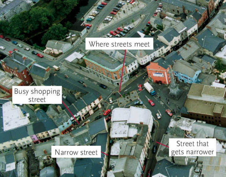
Traffic Problems and Solutions
Urban areas often face traffic congestion, especially in:
- Main shopping streets (like the Central Business District).
- Narrow streets where traffic can bottleneck.
- Street junctions where roads intersect or at bridges.
Traffic Solutions:
- Traffic lanes and traffic lights at busy junctions.
- Yellow box grids to regulate flow at intersections.
- Roundabouts to reduce traffic delays.
- Parking restrictions to keep streets clear.
- Car parks and multi-storey parking facilities for off-road parking.
- One-way streets to streamline traffic.
- Pedestrianised streets where vehicles aren't allowed.
- By-pass or ring roads to divert traffic around the town centre.
Urban Planning
Evidence of urban planning in aerial photos includes:
- Traffic management features like those listed above.
- Zoned areas for specific uses such as residential, industrial, or shopping.
- Grid street patterns that create rectangular blocks of buildings.
- Green areas like parks to provide recreational space.
- Town squares that serve as focal points for social activity.
- Trees along streets for greenery and shade.
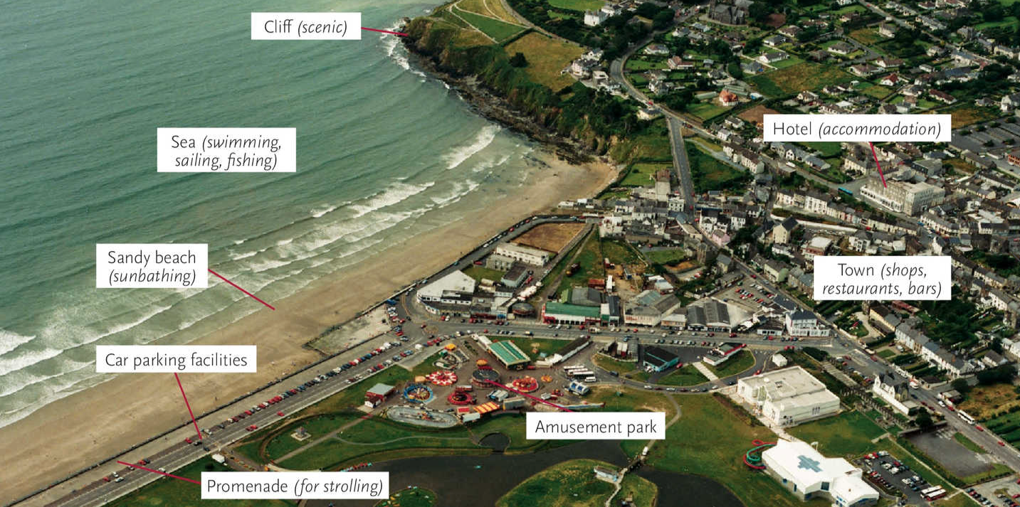
Recreation and Tourism in Photographs
Recreational and tourism services visible in aerial photographs include:
- Scenic areas like cliffs or viewpoints.
- Beaches for swimming or sunbathing.
- Promenades for walking or leisure.
- Car parks and hotels near tourist sites.
- Amusement parks and ornamental lakes for entertainment.
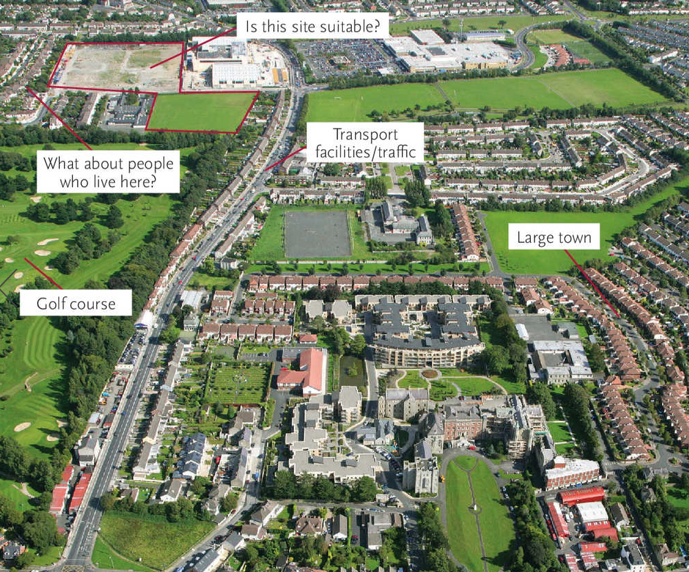
Locating Large Buildings
When using photographs to determine a suitable location for large buildings, consider:
- Site size and accessibility for buildings like schools, factories, or leisure centres.
- Transport facilities for ease of access.
- Nearby amenities such as residential areas for a school or customer base for a retail centre.
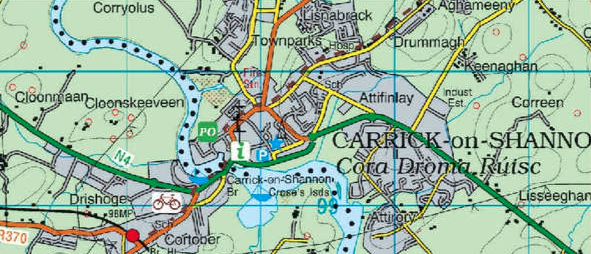
Comparing Maps with Aerial Photographs
Maps and aerial photographs each offer unique advantages:
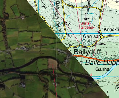
- Maps:
- Show features to scale, with distance calculations.
- Use contours and spot heights to show elevation.
- Name places and label road types.
- Photographs:
- Show features realistically and offer current views of growth, traffic, or crop conditions.
- May indicate day-to-day changes, like seasonal growth or weather effects.