Settlement in Ireland (Junior Cert Geography): Revision Notes
Settlement in Ireland
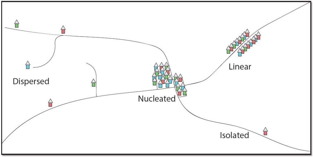
What are settlement patterns?
Settlement patterns show us how people arrange their homes and buildings across the landscape. Understanding these patterns helps geographers explain why communities develop in certain ways and locations.
Settlement patterns describe how houses and buildings are organised and distributed across an area.
There are three main types of settlement patterns found in Ireland:
Linear settlement
Buildings form a line, typically following natural or human-made features. You'll often see this pattern along:
- Major roads and transport routes
- River valleys and coastlines
- Railway lines
This arrangement develops because people want easy access to transport links or natural resources like water.
Linear settlements are particularly common in Ireland along the western coastline, where communities developed following the natural curves of bays and inlets.
Dispersed settlement
Buildings are spread out with large distances between them. This pattern is common in:
- Rural farming areas
- Mountainous regions
- Areas with poor transport links
Farms and isolated houses characterise this pattern, where each building sits on its own plot of land.
Nucleated settlement
Buildings cluster together to form villages, towns, or cities. People group around important features such as:
-
Churches and religious centres
-
Markets and shopping areas
-
Major road junctions and crossroads
-
Railway stations
Why do nucleated settlements develop?
Several physical factors encourage people to cluster their buildings together:
Altitude and relief
- Lowland areas attract settlement because they offer shelter from harsh weather
- Valley floors provide protection from strong winds and extreme temperatures
- Upland regions are often avoided due to difficult building conditions and harsh climate
Drainage patterns
- River locations provide essential water supplies for drinking, washing, and farming
- Good drainage near rivers offers fertile land for agriculture
- Bridging points where roads cross rivers become natural gathering places for trade and settlement
Ireland's numerous rivers, including the Shannon, Boyne, and Liffey, have been crucial in determining settlement locations throughout history.
Land quality
- Fertile soils in valleys and plains support successful farming communities
- Well-drained land allows for stable building foundations
- Rich agricultural areas can support larger populations, leading to village and town development
Ireland's settlement history
Prehistoric settlers
Ireland's earliest inhabitants chose settlement locations carefully:
- Mesolithic peoples (hunter-gatherers) preferred coastal areas and river valleys for fishing and hunting
- Neolithic farmers selected fertile, sheltered sites with good access to water sources
Viking influence (9th century onwards)
Vikings established Ireland's first true towns:
- Built coastal settlements like Dublin, Wexford, and Waterford
- Located at river mouths for easy access to both sea and inland trade routes
- These became major centres for commerce and defence

The Viking settlements fundamentally changed Irish society by introducing the concept of towns and urban trading centres, which had not existed before their arrival.
Norman period (after 1170)
The Anglo-Normans transformed Irish settlement patterns:
- Built castles and walled towns like Kilkenny and Trim
- Many of today's major towns began as Norman settlements
- Created planned, defensive communities with organised street layouts
Plantation towns (16th-17th centuries)
During the Plantation period, new planned settlements emerged:
- Towns like Portlaoise and Derry were deliberately designed and built
- Featured organised street patterns and central market squares
- Established to control territory and encourage English and Scottish settlement
Modern settlement trends
Today's settlement patterns reflect changing lifestyles and economic factors:
Rural patterns
- Western Ireland maintains dispersed settlement patterns
- Scattered farmhouses continue traditional rural living
- Many areas experience population decline as people move to cities
Urban growth
- Eastern regions, especially around Dublin, show strong nucleated patterns
- Towns and cities expand outwards creating suburban areas
- Modern transport links shape where people choose to live
Commuting and mobility
-
Improved roads and public transport allow people to live further from work
-
Suburban development creates new nucleated settlements around major cities
-
Traditional settlement patterns change as people commute longer distances
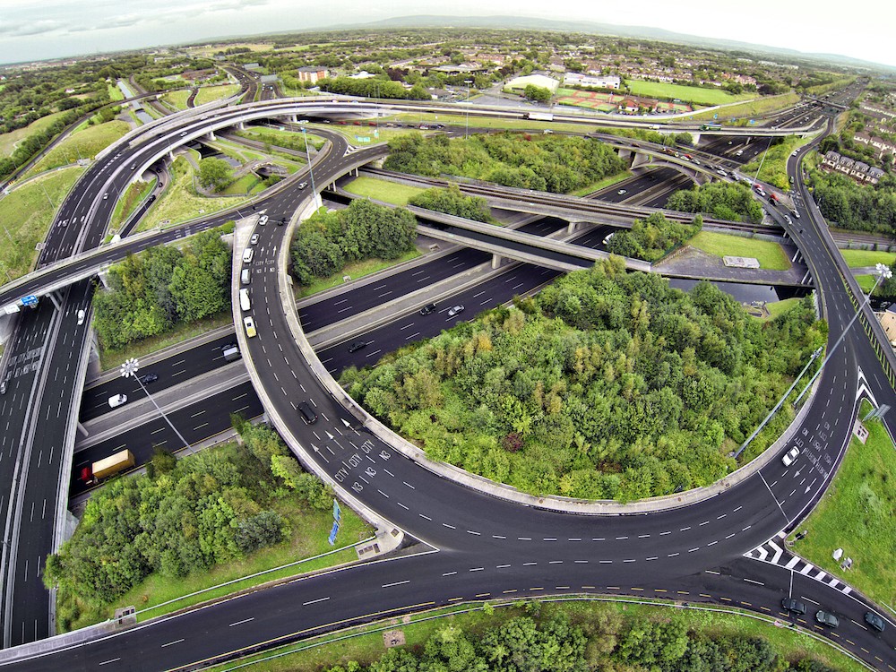
The development of the M50 motorway around Dublin has significantly influenced settlement patterns, creating new suburban communities and changing commuting behaviours.
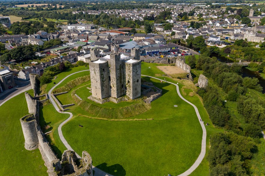
Case study: Trim, Co. Meath
Case Study Analysis: Trim, Co. Meath
Trim demonstrates how historical factors shape modern settlements:
Location advantages:
- Developed along the River Boyne in a fertile lowland valley
- Strategic position provided water supply and transport links
- Rich agricultural land supported growing population
Historical development:
- 12th century: Normans built Trim Castle as a defensive stronghold
- Castle location created a focal point for settlement growth
- Medieval period: Town developed around the castle with planned streets and market areas
Modern characteristics:
- Trim maintains its nucleated layout centred on the historic castle
- Functions as a heritage tourism centre attracting visitors
- Balanced mix of residential, commercial, and tourism services
- Traditional street pattern preserved while accommodating modern housing developments
The town shows how geographic advantages and historical events combine to create lasting settlement patterns.
Modern settlement trends
Today's settlement patterns reflect changing lifestyles and economic factors:
Rural patterns
- Western Ireland maintains dispersed settlement patterns
- Scattered farmhouses continue traditional rural living
- Many areas experience population decline as people move to cities
Urban growth
- Eastern regions, especially around Dublin, show strong nucleated patterns
- Towns and cities expand outwards creating suburban areas
- Modern transport links shape where people choose to live
Commuting and mobility
- Improved roads and public transport allow people to live further from work
- Suburban development creates new nucleated settlements around major cities
- Traditional settlement patterns change as people commute longer distances
The development of the M50 motorway around Dublin has significantly influenced settlement patterns, creating new suburban communities and changing commuting behaviours.
Key Points to Remember:
- Three settlement patterns: Linear (along lines), dispersed (spread out), and nucleated (clustered together)
- Physical factors matter: Altitude, drainage, and land quality influence where people build communities
- Ireland's settlement story: From prehistoric coastal sites to Viking towns, Norman castles, and Plantation settlements
- Modern trends: Urban growth in the east, rural dispersal in the west, and changing commuting patterns
- Historical influence continues: Places like Trim show how past decisions shape today's communities