Planning Policies (Leaving Cert Construction Studies): Revision Notes
📚 Revision Notes
Planning Policies
Planning policies control how land and settlements are developed so that growth is organised, sustainable, and meets community needs. In Ireland, planning happens at national, regional, and local levels.
National Level
1. National Planning Framework (NPF)
- The NPF is Ireland's primary planning policy, introduced under Project Ireland 2040.
- It is a long-term plan for how Ireland will develop by 2040.
- Its aims to:
- Grow towns and cities in a compact way (build within existing areas instead of spreading out into the countryside).
- Spread jobs and services more evenly across the country.
- Reduce the need for long car journeys by placing housing near schools, shops, and workplaces.
2. National Development Plan (NDP)
- Works alongside the NPF – it is the spending plan to make the NPF goals happen.
- Covers a 10-year period (currently 2021–2030).
- Funds infrastructure such as:
- Housing and regeneration
- Public transport, roads, and greenways
- Schools and healthcare facilities
- Ensures that growth happens in line with the NPF, not randomly.

Regional Level
3. Regional Spatial and Economic Strategies (RSES)
- Each of the three Regional Assemblies (Eastern & Midland, Northern & Western, Southern) prepares an RSES.
- Links national goals with local priorities.
- Identifies Key Growth Areas such as cities, towns, ports, and transport corridors.
- Encourages co-operation between counties in areas such as:
- Economic development
- Environmental protection
- Strategic transport links
Local Level
4. Local Planning – County and City Development Plans
- Local authorities produce Development Plans (every six years) that zone land for:
- Residential
- Commercial
- Industrial
- Agricultural uses.
- They also discuss:
- Building heights and densities
- Locations for public amenities (parks, sports facilities, schools)
- Conservation of protected structures and heritage sites
- All planning applications are assessed against the Development Plan.
5. Local Area Plans (LAPs)
- LAPs are more detailed plans applying to towns, villages, or specific neighbourhoods.
- They are more detailed than Development Plans.
- Include:
- Urban design rules
- Local infrastructure needs
- Precise building layouts and public space requirements
infoNote
What is Land Zoning?
Land zoning is the process of dividing land into different areas, or zones, to control how it can be used. Each zone has rules that set out what type of development is allowed, such as housing, shops, industry, farming, or open space. Zoning helps towns and cities grow in an organised way, prevents unsuitable land uses from being placed next to each other, and ensures that essential services and facilities are provided where people live and work.
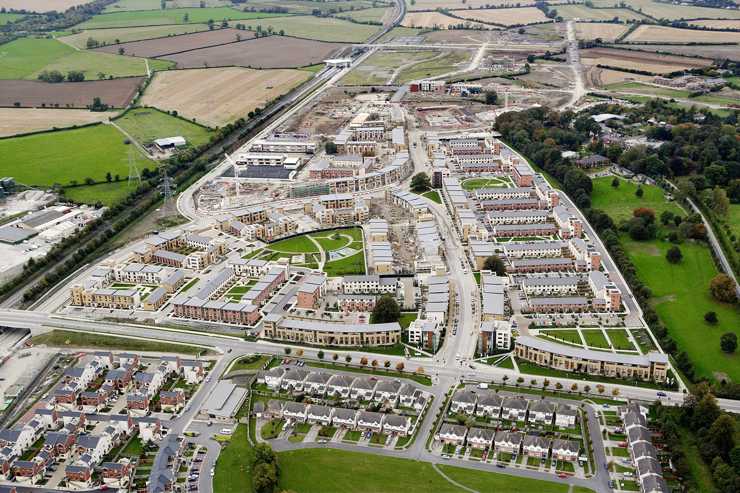
Case Study: Adamstown, Co. Dublin
- Location: Adamstown is a planned suburb about 16 km west of Dublin city centre, within South Dublin County.
- Start date: Construction began in 2006 as part of the Strategic Development Zone (SDZ) planning process – this allowed a master plan to be agreed in advance, speeding up individual planning applications.
- Purpose: To create a self-contained, sustainable community rather than a dormitory town that depends entirely on commuting.
- Design features:
- Housing: Mixture of apartments, duplexes, and houses, providing for different family sizes and incomes.
- Services and Amenities: Schools, childcare facilities, sports pitches, playgrounds, and healthcare services included in the original plan.
- Shops and Employment: A district shopping centre and smaller neighbourhood centres to provide daily needs within walking distance.
- Transport: Served by Adamstown railway station (Dublin–Kildare line) and connected to major bus routes; cycle lanes and pedestrian pathways throughout the area.
- Green Spaces: Parks, green corridors, and recreational areas integrated into housing layouts.
- Planning Principles in Action:
- Compact Growth: Development concentrated in one planned area instead of spreading across the countryside.
- Mixed-Use Zoning: Shops, schools, and leisure facilities close to homes.
- Public Transport-Oriented Development: Homes located within easy walking distance of train and bus services.
- Impact: Adamstown is seen as a model for sustainable suburban growth, although like many large projects, its development has been phased over many years in response to economic conditions.

infoNote
Sustainable Planning Principles
- Compact Growth – focus new housing in existing towns and cities.
- Active Travel – design layouts for walking and cycling.
- Public Transport-Oriented Development – locate new housing near bus and rail services.
- Green Infrastructure – integrate parks, greenways, and biodiversity corridors into developments.
- Climate Resilience – avoid building in flood-prone areas and use energy-efficient designs.
infoNote
Key Terms
- Urban Sprawl – Low-density, unplanned growth on the edges of urban areas.
- Ribbon Development – One-off houses built along roads, stretching out a town's boundaries.
- Zoning – Dividing land into areas for specific uses.
- Compact Growth – Building within existing built-up areas to make better use of space.