Where Earthquakes Occur (Leaving Cert Geography): Revision Notes
Where Earthquakes Occur
Global distribution of earthquakes
Earthquakes are not randomly scattered across the Earth's surface. Instead, they follow distinct patterns that closely match the boundaries between tectonic plates. When you examine a global map of earthquake activity, you'll notice that these seismic events form clear lines and clusters that outline the edges of major tectonic plates.
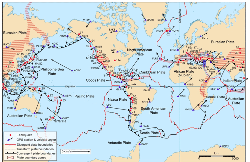
The most striking feature of global earthquake distribution is the Pacific Ring of Fire. This horseshoe-shaped zone around the Pacific Ocean contains approximately 80% of all earthquake activity worldwide. The ring extends from the western coasts of North and South America, across to Japan, the Philippines, and down to New Zealand.
The Pacific Ring of Fire's distinctive pattern isn't coincidental - it directly corresponds to the locations where oceanic plates meet continental plates or other oceanic plates, creating the perfect conditions for intense seismic activity.
Elastic rebound occurs when enormous forces stretch rock layers until they suddenly snap back into position. This rapid movement releases massive amounts of stored energy, triggering earthquakes. Think of it like stretching an elastic band until it breaks - the sudden release of tension creates the seismic waves we feel as earthquakes.
Destructive boundaries
The most powerful and frequent earthquakes occur along destructive plate boundaries, also known as convergent boundaries. These locations experience the most intense seismic activity because of the enormous forces involved when plates collide.
Oceanic-oceanic subduction zones
At oceanic-oceanic boundaries, the denser plate is forced downwards into the mantle beneath the less dense plate. This process creates subduction zones where tremendous friction develops between the colliding plates. As the descending plate slides beneath the overlying plate, it encounters resistance that causes pressure to build up over many years.
Eventually, this accumulated pressure becomes too great for the rock to withstand. When the rock finally breaks, it releases the stored energy in a sudden, violent movement that generates strong earthquakes. These earthquakes can occur at various depths:
- Shallow earthquakes (less than 70km deep) near the surface
- Intermediate earthquakes (70-300km deep) as the plate descends
- Deep earthquakes (over 300km deep) far below the surface
Real-World Example: Japan's Subduction Zone
The Pacific Plate subducts beneath the Eurasian Plate, creating frequent and often devastating earthquakes. In 2011, this subduction process generated a magnitude 9.0 earthquake that also triggered a massive tsunami, demonstrating the immense power released when accumulated pressure finally breaks free.
Continental-continental boundaries
When two continental plates collide, neither can subduct because they have similar densities. Instead, the collision forces rock layers to buckle upwards, forming mountain ranges like the Himalayas. This process generates shallow earthquakes that can be particularly destructive because their focus is close to the Earth's surface.
The collision between the Indo-Australian and Eurasian Plates creates regular earthquake activity along the boundary between India and China. Although these earthquakes may not be as powerful as those at subduction zones, their shallow depth means seismic waves have less distance to travel before reaching populated areas, often resulting in significant damage.
Passive boundaries
Transform faults or passive boundaries occur where plates slide horizontally past each other. The most famous example is the San Andreas Fault in California, where the Pacific Plate moves north-westerly relative to the North American Plate.
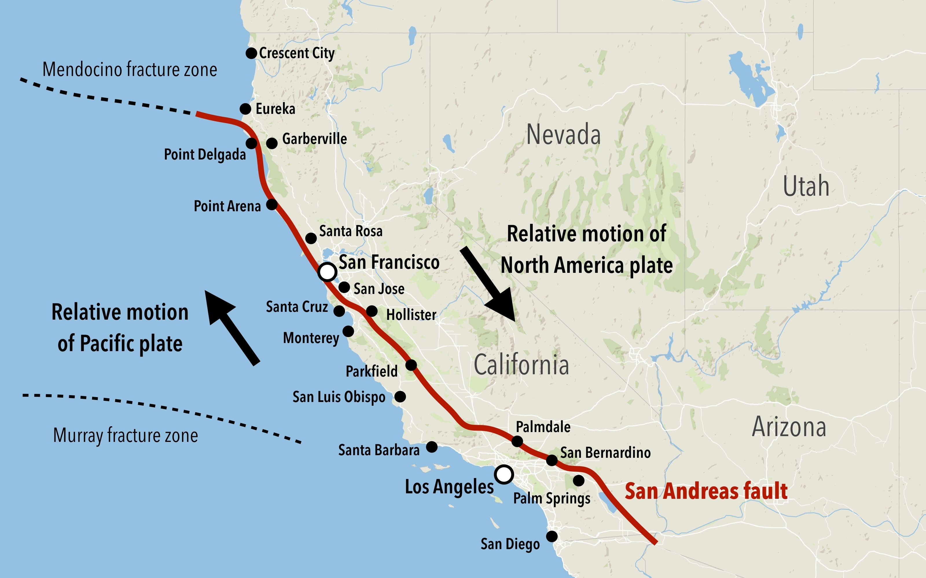
The San Andreas Fault system
This fault system extends over 800 kilometres along the western coast of the United States. The Pacific Plate moves at an average rate of 1 centimetre per year, but this movement isn't smooth. Instead, friction causes the plates to lock together for many years, building up enormous pressure along the fault line.
When this pressure finally overcomes the friction holding the plates together, it releases suddenly in a violent earthquake. The 1906 San Francisco earthquake (magnitude 8.3) and the 1989 Loma Prieta earthquake demonstrate the destructive potential of this fault system.
Historical Example: San Andreas Fault Earthquakes
- 1906 San Francisco: Magnitude 8.3 earthquake caused widespread destruction
- 1989 Loma Prieta: Demonstrated ongoing seismic activity along the fault system
- Both events show how accumulated pressure releases suddenly after years of gradual buildup
Scientists have identified a section of the San Andreas Fault where pressure levels are building rapidly. They predict that when this pressure releases, it will create a massive earthquake known as 'The Big One', potentially occurring by 2032. Recent increases in smaller earthquake activity suggest the fault may be entering a more active phase.
Divergent boundaries
Although much less frequent, earthquakes do occur at divergent boundaries where tectonic plates move apart from each other. These earthquakes are generally weaker and occur at shallow depths.
Mid-ocean ridges
Along mid-ocean ridges such as the Mid-Atlantic Ridge, new oceanic crust forms as magma rises from the mantle. The movement of magma through gaps in the crust can trigger low-magnitude earthquakes, similar to those that occur before volcanic eruptions.
Continental rift valleys
Divergent boundaries on land create rift valleys where the continental crust splits apart. The East African Rift Valley provides an excellent example of this process. As convection currents pull the continent apart, rock layers bend and break under the stress, leading to earthquakes through elastic rebound.
Case Study: East African Rift Valley
In 2006, Mozambique experienced a magnitude 7.0 earthquake along the southern section of the East African Rift, demonstrating that even divergent boundaries can generate significant seismic activity when continental crust splits apart.
Key factors affecting earthquake distribution
Several factors determine where earthquakes occur most frequently:
- Plate boundary type: Destructive boundaries generate the most frequent and powerful earthquakes
- Depth of focus: Shallow earthquakes cause more surface damage than deep ones
- Rate of plate movement: Faster-moving boundaries accumulate pressure more quickly
- Rock type and structure: Some rock formations are more prone to sudden failure than others
Understanding these factors helps scientists predict where future earthquake activity is most likely to occur and assess the relative risk levels for different regions around the world.
Key Points to Remember:
- Nearly all earthquakes occur at plate boundaries, with 80% concentrated around the Pacific Ocean's subduction zones
- Destructive boundaries produce the most frequent and powerful earthquakes due to the enormous forces involved in plate collision
- Transform faults like the San Andreas create periodic major earthquakes when accumulated pressure releases suddenly
- Divergent boundaries generate weaker, shallow earthquakes as plates separate and new crust forms
- The depth of an earthquake's focus significantly affects how much damage it causes at the surface