Drawing Skills: Sketch Maps and Cross-Sections (Leaving Cert Geography): Revision Notes
📚 Revision Notes
Drawing Skills: Sketch Maps and Cross-Sections
Sketch Maps
What is a Sketch Map?
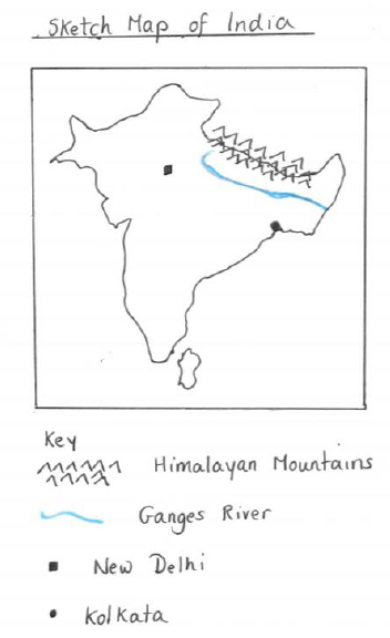
- A simplified, hand-drawn version of a detailed map.
- Highlights key features such as physical landmarks, settlements, or transport routes.
Steps for Drawing a Sketch Map
1. Frame the Area:
- Draw a rectangle to represent the map's boundary.
- Use the grid lines to guide proportions.
2. Simplify the Features:
- Include only the essential features relevant to the task (e.g., rivers, towns, roads).
- Use symbols or labels for clarity.
3. Add a Key:
- Provide a legend to explain symbols (e.g., triangles for mountains, dashed lines for trails).
4. Add Scale and Orientation:
- Include a scale bar and a north arrow.
Cross-Sections
What is a Cross-Section?
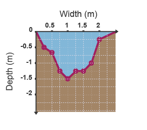
A side view that shows the elevation and shape of the land along a straight line, usually between two points on an OS map.
Steps for Drawing a Cross-Section
1. Select the Line:
- Identify the start (A) and end (B) points on the map.
2. Mark Contour Lines:
- Draw a horizontal baseline on graph paper and mark the distances along it corresponding to the map's scale.
- Plot the elevation at each contour line by marking the height above sea level.
3. Join the Points:
- Connect the plotted points with a smooth line to show the land's profile.
4. Label the Features:
- Mark key features such as peaks, valleys, or rivers.
Applications of Sketch Maps and Cross-Sections
Representing Landforms
- Use cross-sections to illustrate valleys, ridges, or mountains.
- Use sketch maps to identify features like rivers and settlements.
Analysing Spatial Relationships
- Visualise how physical features influence human activity, such as towns near rivers or roads crossing valleys.
Tips for Success
- Use pencils and rulers for neatness and accuracy.
- Always label key features clearly.
- Practice simplifying detailed maps into sketch maps and plotting accurate cross-sections.