Folding and Faulting Activity (Leaving Cert Geography): Revision Notes
Folding
What is folding?
Folding happens when layers of rock are pushed together and compressed due to the movement of tectonic plates. When plates collide, enormous pressure builds up, causing the rock layers to bend and buckle rather than break. This process creates fold mountains - elevated areas of land that rise high above the surrounding landscape.
The key to understanding folding lies in the behaviour of rock under different conditions. Rocks near the Earth's surface are hard and brittle, so they tend to crack under pressure. However, rocks buried deeper in the Earth's crust become heated and compressed over long periods. This makes them ductile, meaning they can bend and change shape without breaking.
Key Terms:
Ductile: Flexible rock that can change its shape without breaking
Buckle: When rocks change shape and bend under pressure without breaking
Parts of a fold mountain
Every fold mountain has three main structural components that you need to recognise:
- Anticline - This is the rock that has been folded upwards, creating the peaks and ridges of the mountain
- Syncline - This is the rock between the anticlines that has been folded downwards, forming valleys
- Limbs - These are the sloping sides that connect the anticlines and synclines
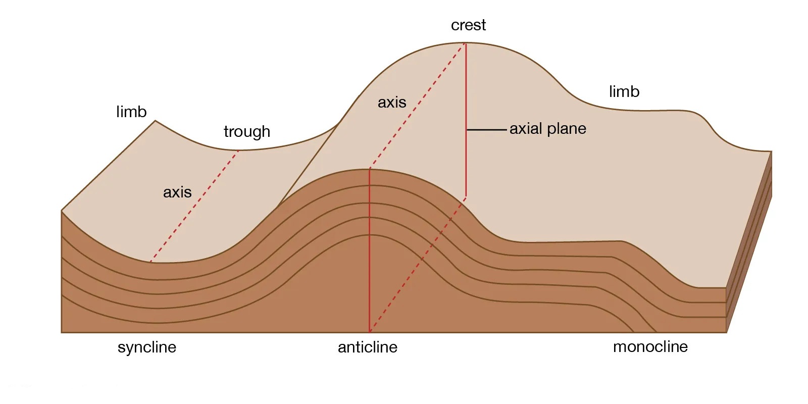
Think of it like a series of arches and troughs. The anticlines form the high points (like upside-down U shapes), while the synclines form the low points (like right-way-up U shapes). The limbs are simply the sloping connections between them.
Types of folds
The type of fold that forms depends on how much pressure each tectonic plate exerts during collision. There are three main types:
Symmetrical folds occur when both colliding plates apply equal pressure. This creates evenly balanced folds where both limbs slope at similar angles.
Asymmetrical folds form when one plate pushes slightly harder than the other. This results in uneven folds where one limb is steeper than the other - the fold becomes lopsided.
Overturned folds develop when one plate applies much more pressure than the other. The intense pressure causes the rock to fold so extremely that it actually folds over on itself.
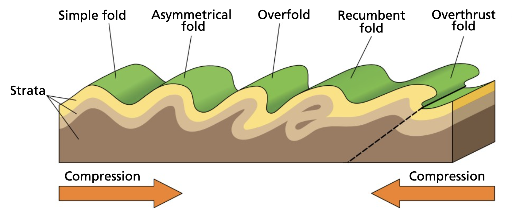
Fold Types:
Symmetrical: Evenly shaped folds where both sides match
Asymmetrical: Lopsided folds where one side has been pushed over more than the other
Overturned: Extreme folds where one plate has folded completely over on itself
Recumbent (overturned) fold: A recumbent fold happens when compression pushes the rocks so much that the fold tips over, and both limbs lie almost flat in the same direction.
Overthrust fold: An overthrust fold happens when pressure is so strong that the rocks fracture, and one limb of the fold is forced up and over the other, leaving the layers out of line.
Location of fold mountains
Fold mountains form at convergent plate boundaries where tectonic plates collide. There are two main types of convergent boundaries where folding occurs:
Continental-oceanic convergence happens along coastlines where a continental plate meets an oceanic plate. When they collide, the heavier oceanic plate slides beneath the continental plate (subduction). This process causes the edges of the continental plate to buckle upwards, creating coastal mountain ranges. The Andes Mountains in South America formed this way when the oceanic Nazca Plate subducted beneath the South American Plate.
Continental-continental convergence occurs when two continental plates of similar density collide. Since neither plate can easily subduct, both plates are pushed together with tremendous force. This compression causes layers of sedimentary rock to buckle upwards, forming extensive mountain ranges. The Himalayas formed through this process when the Indo-Australian Plate collided with the Eurasian Plate.
Periods of folding
Mountain building has occurred during specific time periods called orogenies. These represent major episodes of tectonic activity that created many of the world's mountain ranges. Three main orogenies have shaped the global landscape:
Caledonian folding period (450-400 million years ago)
The Caledonian orogeny created the oldest mountains in Ireland. This period began when the North American and Eurasian Plates collided, forming a continental-continental plate boundary. The collision continued for about 50 million years, during which enormous pressure caused layers of shale, mudstone and sandstone to buckle upwards.
As the folds developed, magma rose from beneath and cooled to form igneous rock underneath the anticlines. The heat from this rising magma transformed some of the overlying sedimentary rock into metamorphic rock. For example, sandstone layers changed into quartzite, which now forms caps on peaks like Croagh Patrick in County Mayo.
Formation Example: Croagh Patrick
- Original sedimentary layers of sandstone deposited
- Tectonic collision creates pressure and heat
- Sandstone transforms into quartzite through metamorphism
- Folding creates anticline structure
- Erosion exposes the resistant quartzite cap at the peak
Caledonian mountains in Ireland include the Wicklow Mountains, Maumturk Mountains and Derryveagh Mountains. These mountains run in a northeast to southwest direction and typically reach heights between 600-700 metres. Weathering and erosion have worn them down significantly over hundreds of millions of years.
Armorican folding period (270-250 million years ago)
The Armorican orogeny was the next major mountain-building episode to affect Ireland. This occurred when the African and Eurasian Plates collided, creating another continental-continental boundary. The pressure caused layers of sandstone and limestone to buckle into a series of anticlines and synclines running in an east-west direction.
This folding process created the Munster Ridge Valley, which shapes much of the landscape in Munster today. The ridges represent the sandstone anticlines that formed during folding. These sandstone ridges were originally covered by limestone layers, but limestone weathers much faster than sandstone. Over millions of years, the softer limestone eroded away, creating deep valleys between the resistant sandstone ridges.
Rivers like the Lee, Bandon and Blackwater now flow through these valleys, continuing the erosion process. The highest peak created during this period is Carrantouhill (1,037 metres), Ireland's tallest mountain, located in the Macgillycuddy's Reeks.
Formation Example: Munster Ridge Valley System
- Sedimentary layers of sandstone and limestone deposited
- African and Eurasian Plates collide (270-250 mya)
- Pressure creates east-west trending anticlines and synclines
- Limestone weathers faster than sandstone over time
- Valleys form where limestone eroded, ridges remain as resistant sandstone
- Modern rivers flow through these valleys, continuing erosion
The Armorican orogeny also uplifted the karst region of the Burren above sea level. The Burren's limestone had formed under the sea 100 million years before the mountain-building began.
Karst region: An area of limestone that has been exposed to the surface and shaped by chemical weathering
Alpine folding period (60 million years ago to present)
The Alpine orogeny represents the most recent period of major mountain building, and it's still active today. Unlike the previous two orogenies, the Alpine period has not directly affected the Irish landscape. However, it has created some of the world's most spectacular mountain ranges.
The Alpine folding period is still ongoing today, making it unique among the three major orogenies. This is why mountains like the Himalayas continue to grow taller each year.
The Alps formed when the Eurasian and African Plates collided. Sediment from the surface was uplifted and folded into weak mudstone folds initially. Over time, these mountains grew rapidly as sandstone layers buckled and folded into anticlines reaching over 4,000 metres in height. The synclines between peaks have been carved into steep valleys by glacial erosion over the past 2 million years. Mount Blanc in France reaches 4,807 metres and represents the highest Alpine peak.
The Himalayas developed when the Indo-Australian Plate collided with the Eurasian Plate 50 million years ago. The Indian subcontinent had been moving northwards at 15 centimetres per year for 20 million years before the collision. When the plates finally met, the force was so great that it shortened the Indian subcontinent by over 2,000 kilometres and created the world's tallest mountains. Mount Everest reaches 8,848 metres above sea level and continues rising slowly each year as the plates continue pushing together.
The Andes Mountains formed 50 million years ago when the oceanic Nazca Plate collided with the continental South American Plate. The heavier Nazca Plate subducted beneath the South American Plate, causing pressure that made the western edges of the South American Plate buckle upwards. This created the Andes mountain chain, which stretches over 7,200 kilometres. The Nazca Plate continues subducting, so the Andes are still growing. The highest peak is Aconcagua (6,959 metres) in Argentina.
Monoclines and doming structures
Not all folding involves the massive pressures of plate collisions. Smaller-scale earth movements can create other types of folded structures.
Monoclines
Monoclines are upland structures formed from smaller earth movements rather than major plate collisions. They develop when sedimentary rock layers are uplifted slightly and tilted in one direction due to compression. Generally, these rocks tilt only slightly, creating a stepped landscape appearance.
Over time, weathering and erosion break down these tilted rock layers. Since some rocks resist weathering better than others, this process can create plateaus with flat, tabletop appearances. Ben Bulben in County Sligo provides an excellent example of a monocline, where differential erosion has created its distinctive flat-topped profile.
Mass movement: The downslope movement of loose, weathered material under the influence of gravity
Doming
Doming creates round or oval anticline structures that resemble upturned bowls. These features have a high central peak with slopes extending down to their base. The most common cause of doming involves pressure from rising magma beneath the crust. As magma pushes upwards, it forces the overlying sedimentary rock layers to bulge upwards.
Doming can also result from ground deformation when rocks are compressed from multiple directions simultaneously. Weathering and erosion gradually break down the overlying material, exposing older rock layers in the centre of the dome.
The Slieve Bloom dome in Counties Laois and Offaly exemplifies this process. It formed during the creation of the Leinster Batholith 400 million years ago due to pressure from rising magma beneath the surface.
Key Points to Remember:
- Folding occurs when tectonic plates collide and compress rock layers, causing them to bend rather than break due to heat and pressure deep in the Earth's crust
- Fold mountains have three parts: anticlines (upward folds), synclines (downward folds), and limbs (the slopes connecting them)
- Three types of folds exist based on pressure differences: symmetrical (equal pressure), asymmetrical (unequal pressure), and overturned (extreme pressure)
- Ireland's mountains formed during two major orogenies: the Caledonian period (450-400 mya) created northeast-southwest trending mountains, while the Armorican period (270-250 mya) created east-west trending mountains
- The ongoing Alpine orogeny (60 mya-present) continues creating mountains globally, including the Himalayas, Alps, and Andes, though it hasn't directly affected Ireland