River Landforms – Mature Stage (Leaving Cert Geography): Revision Notes
River Landforms - Mature Stage
Understanding the middle course of rivers
During the middle course (mature stage) of a river, the landscape changes dramatically from the steep valleys of the upper course. Here, rivers have more space to move sideways, creating distinctive landforms through both erosion and deposition working together. The gradient becomes gentler, allowing the river to develop characteristic winding patterns and broad valley floors.
The middle course represents a transitional zone where rivers begin to show mature characteristics. Unlike the upper course with its steep gradients and vertical erosion, the middle course is characterised by a balance between erosional and depositional processes that create some of the most recognisable river features.
Meanders
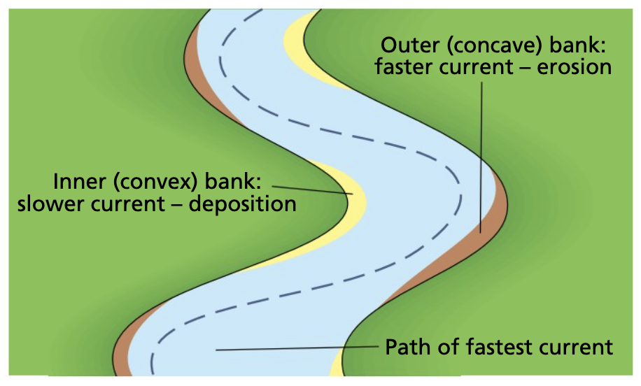
Meanders are distinctive S-shaped loops that form along the middle course of a river. They represent one of the most recognisable features of mature river systems and demonstrate the dynamic nature of flowing water.
How meanders develop
Meanders begin to form when rivers flow across relatively flat land with gentle gradients. The process starts with small irregularities in the riverbed that cause the water to flow in a slightly winding pattern. Once this process begins, it becomes self-reinforcing:
- Uneven water depth creates varying flow speeds - shallow areas (riffles) alternate with deeper sections (pools)
- Water naturally flows from side to side, moving towards the outer bank before returning to the inner bank
- This sideways movement creates the initial small bend that will eventually develop into a full meander
Erosion processes in meanders
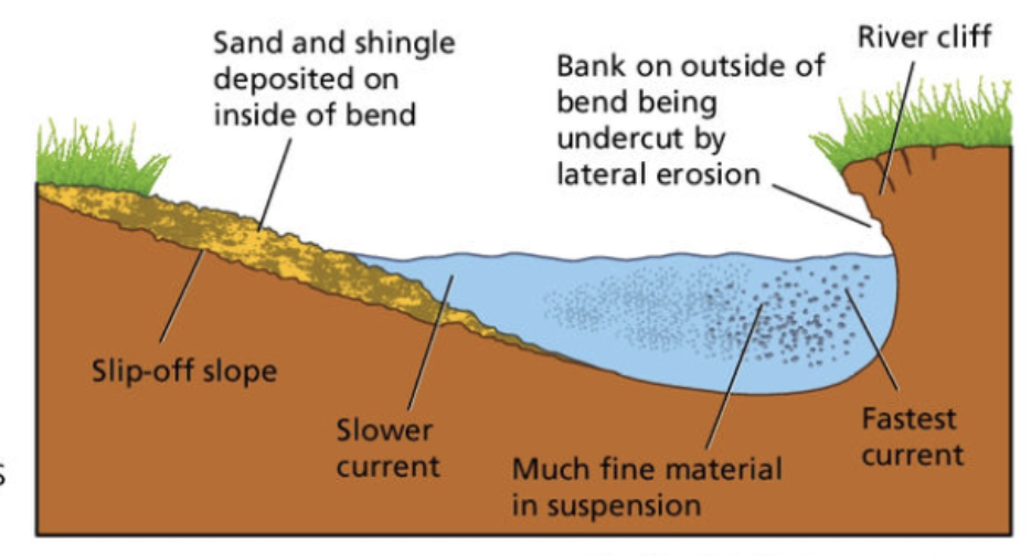
The outer bend of a meander experiences the fastest-flowing water, which leads to intense erosional activity:
- Lateral erosion occurs as the fastest current hits the outer bank
- Hydraulic action breaks down the bank as water crashes against it with force
- Abrasion happens when the river's load scrapes against the outer bank
- Cavitation contributes to erosion as air bubbles in the turbulent water burst and create shock waves
This constant attack on the outer bank causes undercutting, which eventually leads to bank collapse and the formation of a steep river cliff.
Worked Example: Meander Erosion Process
Consider a meander bend in the River Shannon:
Step 1: Fast-flowing water (velocity = 2.5 m/s) hits the outer bank Step 2: Hydraulic action creates pressure up to 30 kN/m² against the bank Step 3: Continuous undercutting weakens the bank structure Step 4: Bank collapse occurs, creating a 3-4 metre high river cliff Step 5: The meander migrates laterally at approximately 0.5 metres per year
Deposition in meanders
While the outer bank experiences erosion, the inner bank tells a different story:
- Water flows more slowly on the inner bend due to friction with the riverbank
- The slower current has less energy to carry sediment
- Sand and gravel are deposited on the inner bank, building up a gently sloping feature called a slip-off slope or point bar
Meander migration
Over time, meanders don't stay in the same position. The continuous erosion of the outer bank and deposition on the inner bank causes meanders to gradually move downstream. This process also widens the valley floor as the river cuts into interlocking spurs, eventually removing most of them. The remaining highest points of these spurs create a line called the bluff line, marking the furthest extent of meander migration.
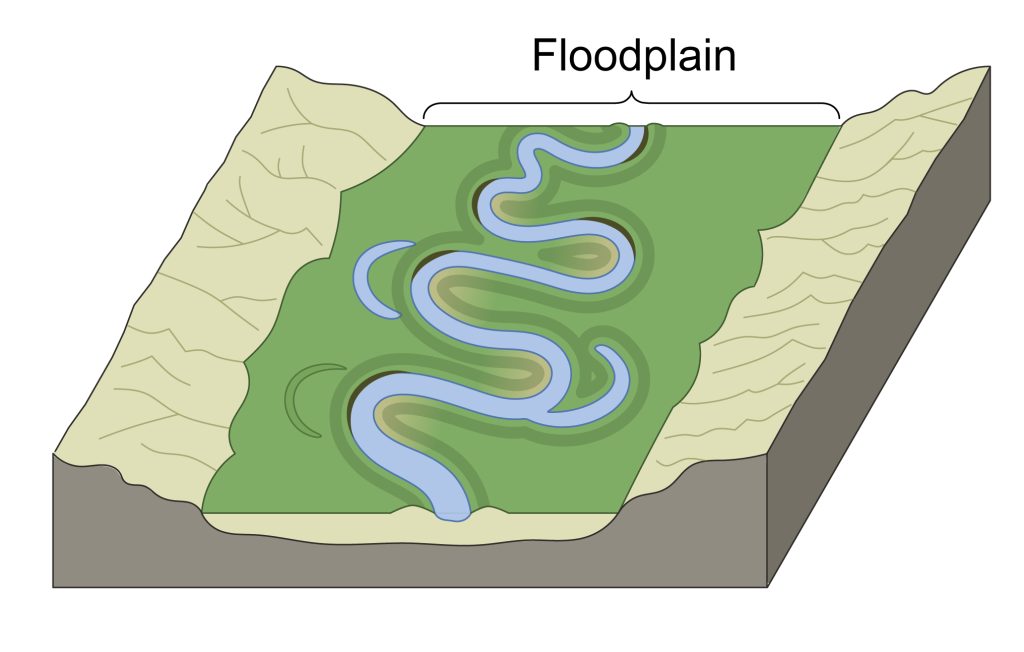
Floodplains
A floodplain is the wide, flat valley floor that becomes covered with water when a river floods during periods of heavy rainfall. Bluff lines mark the outer edges of the floodplain and represent the maximum extent of meander migration.
Formation of floodplains
Floodplains develop through the combined action of meander migration and periodic flooding:
- As meanders migrate downstream over thousands of years, they erode interlocking spurs and widen the valley floor
- The constant sideways movement creates a broad, relatively flat area on either side of the river
- During floods, the river spreads across this flat area, depositing fine sediment
Types of floodplains
There are two main types of floodplains you need to understand:
Erosional floodplains form when meanders migrate and erode the valley sides, creating flat land through the removal of interlocking spurs.
Depositional floodplains develop when rivers regularly flood and deposit layers of fine sediment called alluvium across the valley floor.
The flooding process
When heavy rainfall causes rivers to overflow their banks:
- Water spreads across the entire valley floor between the bluff lines
- As floodwater flows over the flat landscape, it loses energy and speed
- The river deposits its load of fine sediment (mainly sand and silt) in thin layers
- Each flood event adds another layer of alluvium to the floodplain
- Over time, these layers build up to create extremely fertile soil
Agricultural importance
Floodplains represent some of the most valuable agricultural land:
- The regular deposition of alluvium creates nutrient-rich soils
- The flat terrain makes farming easier with modern machinery
- Many of Ireland's most productive agricultural areas are located on river floodplains
- Rivers like the Shannon, Liffey, and Lee have extensive floodplains that support intensive agriculture
The economic value of floodplains extends beyond agriculture. These areas often support major settlements and transportation networks due to their flat terrain and fertile soils. However, this also creates challenges during flood events, requiring careful land-use planning and flood management strategies.
Key Points to Remember:
- Meanders are S-shaped river loops formed by faster flow eroding outer banks while slower flow deposits sediment on inner banks
- Lateral erosion and deposition work together in meanders - erosion creates river cliffs on outer bends whilst deposition builds slip-off slopes on inner bends
- Floodplains are wide, flat valley floors that flood during heavy rainfall and are found in the mature and old age stages of rivers
- Alluvium deposited during floods creates extremely fertile agricultural land, making floodplains economically important
- Meander migration gradually widens valleys by eroding interlocking spurs and creating bluff lines that mark the floodplain boundaries